Líbano, Tolima facts for kids
Quick facts for kids
Líbano, Tolima
|
|||
|---|---|---|---|

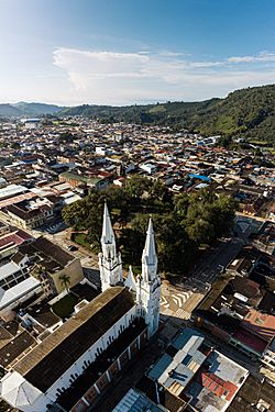
Panoramic photo of Líbano.
|
|||
|
|||

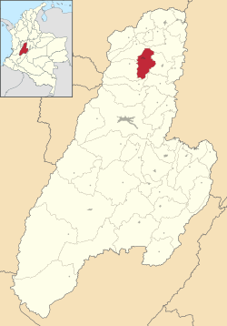
Location of the municipality and town of Líbano, Tolima in the Tolima Department of Colombia.
|
|||
| Country | |||
| Department | Tolima Department | ||
| Area | |||
| • Municipality | 282.4 km2 (109.0 sq mi) | ||
| • Urban | 3.64 km2 (1.41 sq mi) | ||
| Elevation | 1,565 m (5,135 ft) | ||
| Population
(2020 est.)
|
|||
| • Municipality | 36,231 | ||
| • Density | 128.297/km2 (332.29/sq mi) | ||
| • Urban | 23,290 | ||
| • Urban density | 6,398/km2 (16,572/sq mi) | ||
| Time zone | UTC-5 (Colombia Standard Time) | ||
| Website | http://www.libano-tolima.gov.co | ||
Líbano is a town and municipality in the Tolima department of Colombia. It's like a city and the area around it. In 2020, about 36,231 people lived there. Líbano is also an important religious center. It shares this role with the town of Honda.
Contents
History of Líbano
Early Inhabitants
Before Europeans arrived, different groups of people lived in the Líbano area. These included the Panches, Pantagoras, Bledos, and Marquetones. They were known as strong tribes. The Muisca often found them quite challenging. These groups had a society with leaders. A chief was at the very top.
Founding and Growth
In the mid-1800s, settlers from Antioquia moved south. They were looking for new land and mines. A group led by Isidro Parra found a valley. It was full of cedar and oak trees. They built some small homes there. They named their new settlement Líbano. This is the Spanish word for Lebanon.
The town of Líbano was officially planned in 1886. By 1900, Líbano started to grow quickly. Dirt roads were built in all directions. The town's economy first grew with mining. Later, coffee farming became very important. Coffee is now a big part of Líbano's economy and culture.
Religious Importance
Líbano is home to the Diocese of Líbano-Honda. This is a special religious area. Pope John Paul II created it on July 26, 1989. The diocese covers about 3,477 square kilometers. Around 240,000 people live in this area. Monsignor José Luis Serna Alzate was its first bishop. He started his work on October 7, 1989. On December 5, 2015, José Luis Henao Cadavid became the fourth bishop.
Geography of Líbano
Location and Surroundings
The municipality of Líbano is in the northern part of the Tolima department. It is about 56 kilometers (35 miles) north of Ibagué. Ibagué is the capital city of the department. Líbano shares its borders with several other towns. To the north are Armero and Villahermosa. Murillo is to the west. Lérida is to the east. Santa Isabel and Venadillo are to the south.
Landscape and Climate
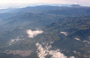
Líbano is located in the Central Mountain Range. This is east of the Nevado del Ruiz volcano. The town sits at an altitude of 1,565 meters (5,135 feet) above sea level. This means it is in the tierra templada, or temperate zone. The area has many hills. It is also heavily forested.
Agriculture and Economy
Where the land is not covered by forests, it is used for farming. Farmers in Líbano grow many crops. These include coffee, bananas, plantains, and beans. Coffee is especially important for the local economy.
Coffee Production in Líbano
Líbano has a long history of producing coffee. There are 77 villages in the municipality. About 3,980 families earn their living by growing coffee.
Líbano's coffee is known for its high quality. For example, in 2019, a farmer named Ómar Arango was recognized. His coffee won an award at the Master of Coffee Colombia competition.
Specialty coffees from Líbano are sent all over the world. They are exported to countries like China, Japan, Korea, the United States, Spain, and England.
Líbano is considered to have the longest coffee history in Tolima. In the 1900s, the town had "threshers." These were machines used to process coffee. They were headquarters for important European coffee companies.
Notable People
- Luís Guillermo Peréz (born 1951), a lawyer who works to protect human rights.
Climate
| Climate data for Líbano (Trinidad La), elevation 1,430 m (4,690 ft), (1971–2000) | |||||||||||||
|---|---|---|---|---|---|---|---|---|---|---|---|---|---|
| Month | Jan | Feb | Mar | Apr | May | Jun | Jul | Aug | Sep | Oct | Nov | Dec | Year |
| Mean daily maximum °C (°F) | 24.3 (75.7) |
24.4 (75.9) |
24.6 (76.3) |
23.9 (75.0) |
23.7 (74.7) |
24.0 (75.2) |
24.8 (76.6) |
25.3 (77.5) |
24.8 (76.6) |
23.6 (74.5) |
23.8 (74.8) |
23.9 (75.0) |
24.3 (75.7) |
| Daily mean °C (°F) | 19.8 (67.6) |
19.9 (67.8) |
20.2 (68.4) |
20.0 (68.0) |
20.0 (68.0) |
19.9 (67.8) |
20.1 (68.2) |
20.4 (68.7) |
20.1 (68.2) |
19.5 (67.1) |
19.6 (67.3) |
19.6 (67.3) |
19.9 (67.8) |
| Mean daily minimum °C (°F) | 16.0 (60.8) |
16.2 (61.2) |
16.5 (61.7) |
16.6 (61.9) |
16.5 (61.7) |
16.0 (60.8) |
15.4 (59.7) |
15.6 (60.1) |
15.9 (60.6) |
16.1 (61.0) |
16.2 (61.2) |
15.9 (60.6) |
16.1 (61.0) |
| Average precipitation mm (inches) | 120.4 (4.74) |
129.0 (5.08) |
180.1 (7.09) |
244.1 (9.61) |
260.9 (10.27) |
133.6 (5.26) |
82.6 (3.25) |
117.7 (4.63) |
227.1 (8.94) |
292.0 (11.50) |
205.0 (8.07) |
128.3 (5.05) |
2,120.8 (83.50) |
| Average precipitation days | 13 | 15 | 18 | 22 | 20 | 14 | 11 | 13 | 17 | 23 | 20 | 16 | 202 |
| Average relative humidity (%) | 83 | 82 | 82 | 86 | 87 | 82 | 75 | 73 | 79 | 86 | 87 | 85 | 82 |
| Mean monthly sunshine hours | 139.5 | 104.6 | 105.4 | 93.0 | 111.6 | 147.0 | 186.0 | 186.0 | 153.0 | 105.4 | 105.0 | 124.0 | 1,560.5 |
| Mean daily sunshine hours | 4.5 | 3.7 | 3.4 | 3.1 | 3.6 | 4.9 | 6.0 | 6.0 | 5.1 | 3.4 | 3.5 | 4.0 | 4.3 |
| Source: Instituto de Hidrologia Meteorologia y Estudios Ambientales | |||||||||||||
See also
 In Spanish: Líbano (Colombia) para niños
 | Roy Wilkins |
 | John Lewis |
 | Linda Carol Brown |


