López de Micay facts for kids
Quick facts for kids
López de Micay
|
|||
|---|---|---|---|
|
Municipality and town
|
|||

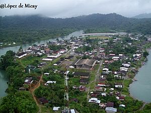
View of López de Micay
|
|||
|
|||

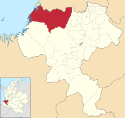
Location of the municipality and town of López de Micay in the Cauca Department of Colombia.
|
|||
| Country | |||
| Department | Cauca Department | ||
| Population
(Census 2018)
|
|||
| • Total | 15,154 | ||
| Time zone | UTC-5 (Colombia Standard Time) | ||
| Climate | Af | ||
López de Micay is a town and a local government area (called a municipality) in the Cauca Department of Colombia. It is located on the Pacific Coast, near the Naya River, at the base of the Colombian Western Mountains. It is about 84 kilometers (52 miles) from Popayán, the capital city of the department.
Contents
History of López de Micay
The first Spanish explorers arrived in this area around 1525. A Spanish explorer named Diego de Almagro found the San Juan de Micay River. It was very hard for them to build settlements here because the land was often flooded, covered in thick forests, and local tribes wanted to protect their homes.
In the years that followed, Spanish ships from Panama came to take gold and capture many local people from the San Juan de Micay River region. These captured people were forced to work in mines and on farms further inland. Sadly, many local people died because of this forced labor. By the late 1600s, there were very few indigenous people left, so people from Africa were brought to work as slaves.
The town of López de Micay was founded in 1888 by Pancracio Riascos, Facundo Riascos, and Luciano Alomía. Before it became a municipality, it had other names, like Arrieros del Micay. This name might have come from its closeness to the El Chambón mining area, which was connected to Popayán by a road called Los Arrieros (meaning "the mule drivers").
The town also had different main centers over time. In 1911, the area of Zaragoza was created as part of the Micay Province. Finally, in 1915, the main settlement of Zaragoza moved to where the town center is today. The name "López de Micay" combines the indigenous name for the river ("Micay") with a tribute to General José Hilario López. In 1851, General López ordered the freedom of all slaves in Colombia. Today, the municipality is called López de Micay, and its main town is called San Miguel de Micay.
Geography of López de Micay
López de Micay shares borders with other areas. To the north, it borders Buenaventura. To the south, it borders Timbiquí and El Tambo, Cauca. To the east, it borders Buenos Aires, Cauca, Suárez, Cauca, and Morales, Cauca. To the west, it meets the Pacific Ocean.
The municipality has two main types of land:
- The coastal zone: This is a wide area along the coastline, affected by ocean tides and river waters.
- The Western Cordillera: This area is on the western side of the Western Mountains. It has many broken and steep hills.
The land in López de Micay can sometimes experience floods, mudslides, and earthquakes.
Rivers in López de Micay
The main rivers in the area are:
- Micay River: Its smaller rivers and streams include Jolí, Chuare, Siguí, Gualala, Santa Barbara, Isla de Gallo, Iguana, Murciélago, Claudio, La Laguna, El Chachajo, El Trapiche, Arenal, Casa Vieja, Platanal, Hercilio, Tambor, Tambito, and Yarumal.
- Naya River: Its smaller rivers and streams include Agua Clara, Dos Quebrada, San Bartolo, Las Pavas, San Francisco, la Puerquera, La Sierpe, Tigre, Aurora, and Guaduatito.
Administrative Divisions
The municipality of López de Micay includes its main town and 34 smaller areas called corregimientos (hamlets). These corregimientos are located along the Micay and Naya rivers.
Corregimientos along the Micay river
- San Antonio de Gurumendy
- Joli
- Brazo Siguí
- Santa Cruz de Singuí
- San Antonio de Chuare
- Playa Grande
- Naicioná
- San Isidro
- Taparal
- Zaragoza
- Guayabal
- Santa Ana
- Nahanamito
- El Trapiche
- Boca Grande
- El Coco
- La Capilla
- Ghiguero
- Calle Larga Micay
Corregimientos along the Naya river
- San Bernando*
- Batanía
- San Pedro de Naya
- El Trueno
- El Cacao
- Las Cruces
- Sangrada Familia
- Dos Quebradas
- San Bartolo
- Las Pavas
- La Concepción
- San Francisco Adentro
- Golondro
- Calle Larga Naya
People of López de Micay
According to the 2018 census, most of the people in López de Micay identify as black, mulatto, or Afro-Colombian (79.1%). About 8% identify as indigenous, and the remaining 13% consider themselves mestizo (a mix of European and indigenous heritage).
The indigenous people living here belong to the Embera and Eperara Siapidara groups. They have their own social rules and ways of organizing their communities. They live in five special areas called "reservations" along the Micay, Naya, and Saija Rivers. These are: Belén De Iguana, Playa Bendita, Isla De Mono, Playita, and San Francisco La Vuelta, Rio Guangüi Indigenous Reservations.
There are also six "Community Councils" that are well-organized and active in the area. These councils manage large parts of the rural land. Even though both indigenous reservations and community councils have legal recognition, the exact borders between their lands are not always clear. This hasn't caused problems between them, but it's something that needs to be sorted out.
Because many people live in rural areas, it can be hard to travel and connect between different settlements, and with nearby towns or the department capital. This is a big challenge for the local government.
Economy of López de Micay
The main ways people make a living in López de Micay are farming, raising animals, fishing, small-scale mining, cutting down trees, and trading goods.
Farming and Livestock
Farmers grow crops like coconut, sugar cane, chontaduro, borojó, papachina, and banana, which they can sell. They also grow corn and bananas for their own families to eat, but these don't usually bring in much extra money. People also cut down trees, especially mangroves, but sometimes this is done without proper rules to protect the forests. Raising animals is also done, but not enough to provide all the meat and dairy products needed locally.
Fishing
Fishing is a very important activity. People fish using traditional methods for their own food and to sell in Buenaventura. However, they often don't make much profit because of the costs of middlemen and transportation. Fishing for river shrimp and a type of shellfish called piangua is common. But, catching shellfish has become harder because of gold mining in the Micay River and its smaller rivers. Some mining methods are not good for the environment. Also, some people use harmful ways to catch fish in the mangrove forests, which hurts the environment.
Mining and Resources
Some studies suggest that there might be oil, marble, and lime in this area, but no big exploration has happened yet. Small-scale mining for gold has been a historical activity in the Chuare, Siguí, and Micay rivers. However, with more large mining companies using big machines like backhoes, it has become harder for local small-scale miners.
Climate
López de Micay is known for being one of the wettest places on Earth! The Colombian weather service, IDEAM, reports that it gets an average of 12,892.4 millimeters (about 507 inches) of rain each year. Some other reports say it gets around 10,191 millimeters (about 401 inches), while others suggest it could be as much as 16,000 millimeters (about 630 inches) annually.
It rains almost every day in López de Micay, with frequent heavy downpours that can cause flash floods. The climate is a tropical rainforest climate (called Af in the Köppen system). The average temperature is about 26.9°C (80.4°F).
| Month | Jan | Feb | Mar | Apr | May | Jun | Jul | Aug | Sep | Oct | Nov | Dec | Year |
|---|---|---|---|---|---|---|---|---|---|---|---|---|---|
| Mean daily maximum °C (°F) | 31.3 (88.3) |
31.9 (89.4) |
32.1 (89.8) |
31.7 (89.1) |
31.6 (88.9) |
31.5 (88.7) |
32.0 (89.6) |
32.0 (89.6) |
31.7 (89.1) |
30.8 (87.4) |
30.6 (87.1) |
30.9 (87.6) |
31.5 (88.7) |
| Daily mean °C (°F) | 26.8 (80.2) |
27.1 (80.8) |
27.2 (81.0) |
27.1 (80.8) |
27.1 (80.8) |
26.8 (80.2) |
26.9 (80.4) |
27.0 (80.6) |
27.0 (80.6) |
26.7 (80.1) |
26.5 (79.7) |
26.5 (79.7) |
26.9 (80.4) |
| Mean daily minimum °C (°F) | 22.9 (73.2) |
22.3 (72.1) |
22.4 (72.3) |
22.6 (72.7) |
22.7 (72.9) |
22.2 (72.0) |
21.8 (71.2) |
22.0 (71.6) |
22.3 (72.1) |
22.6 (72.7) |
22.5 (72.5) |
22.2 (72.0) |
22.4 (72.3) |
| Average rainfall mm (inches) | 940.3 (37.02) |
804.4 (31.67) |
812.9 (32.00) |
1,399 (55.1) |
1,556.1 (61.26) |
1,301.6 (51.24) |
997.9 (39.29) |
935.5 (36.83) |
1,931 (76.0) |
1,641.9 (64.64) |
1,660.2 (65.36) |
2,011.3 (79.19) |
15,992.1 (629.6) |
| Average rainy days (≥ 1 mm) | 26 | 23 | 24 | 25 | 28 | 27 | 26 | 27 | 27 | 28 | 27 | 27 | 315 |
See also
 In Spanish: López de Micay para niños
 | Valerie Thomas |
 | Frederick McKinley Jones |
 | George Edward Alcorn Jr. |
 | Thomas Mensah |


