La Chapelle-Engerbold facts for kids
Quick facts for kids
La Chapelle-Engerbold
|
|
|---|---|
|
Part of Condé-en-Normandie
|
|

La Chapelle-Engerbold
|
|
| Country | France |
| Region | Normandy |
| Department | Calvados |
| Arrondissement | Vire |
| Canton | Condé-en-Normandie |
| Commune | Condé-en-Normandie |
| Area
1
|
4.07 km2 (1.57 sq mi) |
| Population
(2019)
|
100 |
| • Density | 25/km2 (60/sq mi) |
| Time zone | UTC+01:00 (CET) |
| • Summer (DST) | UTC+02:00 (CEST) |
| Postal code |
14770
|
| Elevation | 98–206 m (322–676 ft) (avg. 50 m or 160 ft) |
| 1 French Land Register data, which excludes lakes, ponds, glaciers > 1 km2 (0.386 sq mi or 247 acres) and river estuaries. | |
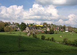
La Chapelle-Engerbold was a small village, also known as a commune, located in northwestern France. It was part of the Calvados department in the Normandy region. A commune is like a local town or parish. A department is a larger area, similar to a county. A region is a big administrative area, like a state.
On January 1, 2016, La Chapelle-Engerbold joined with other nearby villages. They formed a new, larger commune called Condé-en-Normandie. This means La Chapelle-Engerbold is no longer a separate commune on its own. The former commune is located in an area known as Suisse Normande. This area is famous for its beautiful, hilly landscapes.
Population History
This section shows how the number of people living in La Chapelle-Engerbold changed over the years.
| Historical population | ||
|---|---|---|
| Year | Pop. | ±% |
| 1962 | 125 | — |
| 1968 | 109 | −12.8% |
| 1975 | 87 | −20.2% |
| 1982 | 93 | +6.9% |
| 1990 | 86 | −7.5% |
| 1999 | 79 | −8.1% |
| 2008 | 110 | +39.2% |
See also
 In Spanish: La Chapelle-Engerbold para niños
 | Charles R. Drew |
 | Benjamin Banneker |
 | Jane C. Wright |
 | Roger Arliner Young |


