La Ferté-Hauterive facts for kids
Quick facts for kids
La Ferté-Hauterive
|
||
|---|---|---|

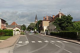
The main road in La Ferté-Hauterive
|
||
|
||
| Country | France | |
| Region | Auvergne-Rhône-Alpes | |
| Department | Allier | |
| Arrondissement | Moulins | |
| Canton | Moulins-2 | |
| Intercommunality | Pays Saint-Pourcinois | |
| Area
1
|
18.88 km2 (7.29 sq mi) | |
| Population
(Jan. 2019)
|
279 | |
| • Density | 14.778/km2 (38.27/sq mi) | |
| Time zone | UTC+01:00 (CET) | |
| • Summer (DST) | UTC+02:00 (CEST) | |
| INSEE/Postal code |
03114 /03340
|
|
| Elevation | 214–239 m (702–784 ft) (avg. 234 m or 768 ft) |
|
| 1 French Land Register data, which excludes lakes, ponds, glaciers > 1 km2 (0.386 sq mi or 247 acres) and river estuaries. | ||
La Ferté-Hauterive is a small commune located in the Allier department in the very center of France. It is a quiet place where people live and work, much like a small town or village.
Contents
Discovering La Ferté-Hauterive
La Ferté-Hauterive is part of the Auvergne region, which is known for its beautiful landscapes and volcanoes. The commune is situated in the Moulins arrondissement. This means it is part of a larger administrative area.
Where is La Ferté-Hauterive Located?
The commune is found in the heart of France. Its exact location can be pinpointed using special coordinates: 46.3975 degrees North and 3.3411 degrees East. These numbers help people find it on a map.
How High is La Ferté-Hauterive?
The land in La Ferté-Hauterive is mostly flat, but it does have some slight changes in height. The lowest point is about 214 meters (702 feet) above sea level. The highest point reaches about 239 meters (784 feet). The average height is around 234 meters (768 feet).
What is the Size of La Ferté-Hauterive?
The total area of the commune is 18.88 square kilometers (about 7.29 square miles). This gives you an idea of how much land the commune covers. It is a fairly small area compared to bigger cities.
People and Community in La Ferté-Hauterive
The number of people living in a place is called its population. This helps us understand how many residents call La Ferté-Hauterive home.
How Many People Live Here?
As of January 2019, the population of La Ferté-Hauterive was 279 people. This shows it is a very small community. The population numbers are tracked by the National Institute of Statistics and Economic Studies.
Who Leads the Commune?
Like any town or city, La Ferté-Hauterive has a leader. This person is called the Mayor. The mayor helps manage the commune and makes decisions for its residents.
Meet the Mayor of La Ferté-Hauterive
The mayor of La Ferté-Hauterive is Rolande Sarrazin. She was elected to serve from 2014 to 2020. The mayor works with a local council to make sure the commune runs smoothly. They handle things like local services and community projects.
Working Together with Other Communes
La Ferté-Hauterive is also part of a group of communes called Pays Saint-Pourcinois. This means it works together with nearby communes on shared projects and services. This cooperation helps all the communities in the area.
More About La Ferté-Hauterive
Explore More About La Ferté-Hauterive
You can find more information about La Ferté-Hauterive in other languages too!
- In Spanish: La Ferté-Hauterive para niños


