La Gloria, Cesar facts for kids
Quick facts for kids
La Gloria, Cesar
|
||
|---|---|---|
|
||

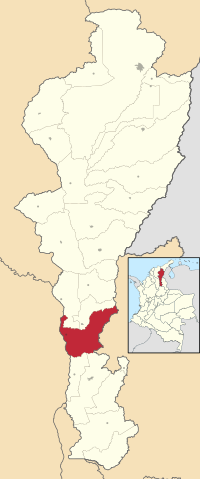
Location of the municipality and town of La Gloria in the Department of Cesar.
|
||
| Country | Colombia | |
| Region | Caribbean | |
| Department | Cesar | |
| Foundation | 1800 | |
| Area | ||
| • Total | 736 km2 (284 sq mi) | |
| Population
(Census 2018)
|
||
| • Total | 14,989 | |
| • Density | 20.365/km2 (52.75/sq mi) | |
| Time zone | UTC-5 | |
| Website | lagloria-cesar.gov.co |
|
La Gloria is a town and municipality in northern Colombia. It is located in the Department of Cesar, right next to the Magdalena River.
Contents
Where is La Gloria located?
La Gloria is found on the eastern side of the Magdalena River. To the north, it shares borders with the towns of Tamalameque and Pelaya. To the south, it borders Gamarra and Aguachica. The Bolívar Department is to its west, and the Norte de Santander Department is to its east.
La Gloria is often called a "bridge" between the southern part of Cesar and the towns in southern Bolívar. People traveling from Bolívar often cross the Magdalena River here. They then take the highway that connects La Gloria to La Mata.
A Look at La Gloria's History
How La Gloria Started
The town and municipality of La Gloria began on December 8, 1800. It was founded by Benito Torices Bermudez, Juan Cruz Uribe, Gregorio Arias, and Hermógenes Maza. They first named it Corregimiento of Belén. At that time, it was part of the Municipality of Simaña.
La Gloria was an important port. It helped river boats carry supplies and passengers along the Magdalena River.
Becoming a Municipality
In 1888, the General Assembly of the Magdalena Department officially created the municipality and town of La Gloria. This happened on July 1, 1888, by order 004. It then became part of the Padilla Province. Later, in 1967, La Gloria joined the Department of Cesar.
What is La Gloria's Economy Like?
La Gloria is known for its growing fishing industry. It also produces many agricultural goods.
Farming and Products
- Rice: Large farms like Santa Ines and Bellacruz grow a lot of rice.
- Sorghum and other cereals: These are grown on a smaller scale.
- Corn: The planting of corn in areas like Ayacucho and La Mata is very famous across Colombia.
- Fishing: The fishing industry is also well-known nationally.
Recently, many rice fields have been replaced. About 90% of them are now used to grow palm trees. These trees are used to produce palm oil.
Getting Around La Gloria
Airports
The municipality has two airports. Both are owned and managed by Ecopetrol. This is a state-owned oil company in Colombia. These airports are located in the areas of Simaña and Ayacucho.
Roads and Railways
La Gloria is connected to other towns in the Cesar Department by a highway. This road leads to the town of La Mata. There is also a railway that links La Gloria to the main towns in the southern part of the department. The La Gloria railway station is very important. The Colombian Ministry of Culture considers it a place of national cultural interest.
River Travel
The Magdalena River makes it easy to travel to other cities. The most important city connected by the river is Barranquilla.
La Gloria's Climate
| Climate data for La Gloria (Mata La), elevation 163 m (535 ft), (1971–2000) | |||||||||||||
|---|---|---|---|---|---|---|---|---|---|---|---|---|---|
| Month | Jan | Feb | Mar | Apr | May | Jun | Jul | Aug | Sep | Oct | Nov | Dec | Year |
| Mean daily maximum °C (°F) | 34.2 (93.6) |
34.7 (94.5) |
34.5 (94.1) |
33.9 (93.0) |
33.5 (92.3) |
33.6 (92.5) |
33.7 (92.7) |
33.5 (92.3) |
33.1 (91.6) |
32.8 (91.0) |
33.0 (91.4) |
33.5 (92.3) |
33.7 (92.7) |
| Daily mean °C (°F) | 28.5 (83.3) |
28.7 (83.7) |
28.6 (83.5) |
28.2 (82.8) |
27.9 (82.2) |
28.0 (82.4) |
28.1 (82.6) |
27.8 (82.0) |
27.4 (81.3) |
27.3 (81.1) |
27.5 (81.5) |
28.0 (82.4) |
28.0 (82.4) |
| Mean daily minimum °C (°F) | 22.2 (72.0) |
22.7 (72.9) |
22.7 (72.9) |
22.9 (73.2) |
22.7 (72.9) |
22.9 (73.2) |
22.6 (72.7) |
22.6 (72.7) |
22.3 (72.1) |
22.4 (72.3) |
22.4 (72.3) |
22.7 (72.9) |
22.6 (72.7) |
| Average precipitation mm (inches) | 36.2 (1.43) |
76.6 (3.02) |
137.8 (5.43) |
246.6 (9.71) |
373.1 (14.69) |
251.6 (9.91) |
187.8 (7.39) |
313.2 (12.33) |
481.7 (18.96) |
389.6 (15.34) |
297.1 (11.70) |
98.9 (3.89) |
2,890.1 (113.78) |
| Average precipitation days | 3 | 4 | 6 | 12 | 16 | 13 | 12 | 16 | 20 | 18 | 14 | 5 | 138 |
| Average relative humidity (%) | 75 | 73 | 74 | 77 | 79 | 80 | 77 | 79 | 79 | 80 | 80 | 78 | 78 |
| Source: Instituto de Hidrologia Meteorologia y Estudios Ambientales | |||||||||||||
See also
 In Spanish: La Gloria (Cesar) para niños
 | Isaac Myers |
 | D. Hamilton Jackson |
 | A. Philip Randolph |


