Aguachica facts for kids
Quick facts for kids
Aguachica
|
||
|---|---|---|
|
Municipality and city
|
||
 |
||
|
||

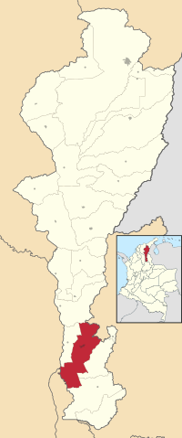
Location in the Department of Cesar. Municipality (red), City (dark gray).
|
||
| Country | Colombia | |
| Region | Caribbean | |
| Department | Cesar | |
| Foundation | August 16, 1748 | |
| Area | ||
| • Municipality and city | 877.7 km2 (338.9 sq mi) | |
| • Urban | 10.85 km2 (4.19 sq mi) | |
| Elevation | 162 m (531 ft) | |
| Population
(2020 est.)
|
||
| • Municipality and city | 118,652 | |
| • Density | 135.185/km2 (350.128/sq mi) | |
| • Urban | 103,209 | |
| • Urban density | 9,512/km2 (24,637/sq mi) | |
| Time zone | UTC-5 | |
| Area code(s) | 57 + 5 | |
| Website | Official website: https://archive.today/20121129184025/http://www.aguachica-cesar.gov.co/sitio.shtml | |
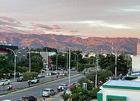
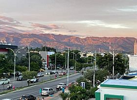
Aguachica (Spanish pronunciation: [aɣwaˈtʃika]) is a city and municipality in the southern part of the Cesar Department in Colombia. It sits between the Magdalena Medio valley and the Motilones mountains. It is the second largest city in the department by population. It is also an important center for farming and trade in the southeast of the Colombian Caribbean.
Aguachica is a key spot for travel. It connects the Colombian Caribbean with the Santanderes region through a major road called Ruta del Sol. It also links to the Catatumbo region using National Route 70. The city has air travel through Hacaritama Airport, a railway system, and a port on the Magdalena River in Gamarra.
Contents
Geography: Where Aguachica Is Located

Aguachica is in the south of the Cesar Department. It is found between the Eastern Mountain Range of the Andes and the Magdalena River. To the north, Aguachica borders La Gloria and the Department of North Santander. To the east, it borders Rio de Oro. To the south, it borders Rio de Oro again, plus San Martín and the Department of Santander. To the west, it borders Gamarra and the Department of Bolívar.
The total area of Aguachica is about 876 square kilometers. This is about 3.8% of the entire Cesar Department.
The northern part of Aguachica is mountainous. It is part of the Eastern Mountain Range. The height above sea level here ranges from 200 meters to 2,150 meters. The southern part of Aguachica is mostly flat. Two main rivers flow through this area: the Magdalena River and the Lebrija River.
History: How Aguachica Grew
Early Times: Before the Spanish Arrived
Long ago, the land where Aguachica is now was home to the Chimila tribes. These were native people who lived there before the Spanish explorers came. Sadly, the Spanish later caused great harm to this tribe.
Spanish Rule: Haciendas and New Settlements
In the early 1600s, the Spanish set up a large farm called the Hacienda de San Roque. It was owned by Don Antonio Garia de Bonilla. But because of sickness, the settlement had to move a short distance south. By 1722, the area had grown. It was mostly part of a large farm owned by Don Casimiro Ramos de Barahona. This settlement became a resting place for traders. They traveled to and from the nearby river port of Gamarra and Ocaña.
In 1748, the settlement was officially recognized. It became a Roman Catholic parish (a church district). Around this time, a Spanish leader named Jose Fernando de Mier y Guerra was told to bring peace to the Chimila groups. He also helped organize some villages along the Magdalena River. These new towns were approved by José Alfonso Pizarro, who was the viceroy (a ruler representing the king) of the Viceroyalty of New Granada. In 1753, the Spanish ordered houses to be built in Aguachica. It became part of the Government of Santa Marta.
Between 1798 and 1804, a terrible sickness spread through the area. It caused many people to move the village to its current location. In 1914, Aguachica officially became a municipality, which is like a local government area.
Modern Times: Growth and Challenges
By 1850, new people started moving to Aguachica. They were drawn by the coffee farms in nearby Ocaña. They also brought new ways of farming and trading to the region. In the 1920s, oil was found in the area. This brought even more people from other parts of Colombia, like Antioquia and Santander.
In the 1950s, a new highway and railroad were built. This made Aguachica a very important place. It connected the Andean mountains with the Caribbean coast. The 1960s saw many farmers from the Department of Tolima move to Aguachica. They wanted to use the land for large farms. They grew crops like cotton, sorghum, and rice. This helped the economy grow, focusing on farm products, trade, and services.
A Time of Challenges
During the 1980s and early 1990s, the region faced some difficult times. This led to many people moving from the countryside and nearby areas into the city of Aguachica.
Heritage Sites: Places of History and Culture
Aguachica has several important historical and cultural places:
- Cerro de la Cruz (The Cross Hill): This is a religious site where people go on pilgrimages. It is a special place for religious traditions.
- San Roque Parish: This church building is very old. It is considered the starting point of the church and history of Aguachica. Records from the 1730s mention its existence. In 1748, Aguachica was officially made a parish.
- Church of Maria Auxiliadora: This church was built by the Comboni Missionaries. They came to Aguachica in 1992 to help the community. The church was finished in 2006.
- Eladio Vargas Cultural Center: This center has been around for over 18 years. Its job is to collect and keep the history, traditions, culture, and folk stories of Aguachica.
Nature Reserves: Exploring Local Wildlife
Aguachica is home to the Agüil Forest, a special nature reserve. This forest is full of life!
- It has 40 different kinds of butterflies.
- You can find 88 types of birds living there.
- The forest covers 8 hectares (about 20 acres).
- It has 200 different kinds of plants.
- Some of the main types of flowers you can see are Acalypha, Machaerium, and Solanum.
Demographics: Who Lives in Aguachica?
According to a 2005 study, Aguachica had a total population of 80,789 people.
- More than half of the people (51%) were female, and 49% were male.
- A small number (0.1%) said they had indigenous (native) family backgrounds.
- About 3.7% said they had Afro-Colombian (African) family backgrounds.
Most people (87%) lived in houses. A smaller number lived in apartment buildings (2.1%) or rented rooms (10%). About 4.8% of these homes were also used for small businesses.
Many homes in Aguachica had important services:
- 90% had electricity.
- 73% had sewage service.
- 87% had water service (aqueduct).
- 50% had natural gas.
- 30% had a telephone line.
Climate: Weather in Aguachica
| Climate data for Aguachica (Aguas Claras), elevation 208 m (682 ft), (1981–2010) | |||||||||||||
|---|---|---|---|---|---|---|---|---|---|---|---|---|---|
| Month | Jan | Feb | Mar | Apr | May | Jun | Jul | Aug | Sep | Oct | Nov | Dec | Year |
| Mean daily maximum °C (°F) | 34.3 (93.7) |
35.0 (95.0) |
34.7 (94.5) |
33.3 (91.9) |
32.3 (90.1) |
32.2 (90.0) |
32.5 (90.5) |
32.6 (90.7) |
31.9 (89.4) |
31.4 (88.5) |
31.6 (88.9) |
32.7 (90.9) |
32.9 (91.2) |
| Daily mean °C (°F) | 29.2 (84.6) |
29.8 (85.6) |
29.7 (85.5) |
28.8 (83.8) |
28.3 (82.9) |
28.1 (82.6) |
28.3 (82.9) |
28.3 (82.9) |
27.9 (82.2) |
27.5 (81.5) |
27.8 (82.0) |
28.2 (82.8) |
28.5 (83.3) |
| Mean daily minimum °C (°F) | 23.2 (73.8) |
24.0 (75.2) |
24.4 (75.9) |
24.3 (75.7) |
23.9 (75.0) |
23.7 (74.7) |
23.5 (74.3) |
23.4 (74.1) |
23.2 (73.8) |
23.3 (73.9) |
23.4 (74.1) |
23.1 (73.6) |
23.6 (74.5) |
| Average precipitation mm (inches) | 16.9 (0.67) |
33.0 (1.30) |
49.7 (1.96) |
145.7 (5.74) |
190.5 (7.50) |
153.0 (6.02) |
124.8 (4.91) |
161.9 (6.37) |
189.7 (7.47) |
161.6 (6.36) |
104.1 (4.10) |
48.2 (1.90) |
1,372.8 (54.05) |
| Average precipitation days | 2 | 3 | 5 | 12 | 14 | 12 | 13 | 14 | 15 | 14 | 10 | 5 | 116 |
| Average relative humidity (%) | 74 | 70 | 72 | 77 | 82 | 82 | 80 | 80 | 81 | 82 | 82 | 78 | 78 |
| Mean monthly sunshine hours | 251.1 | 211.7 | 182.9 | 147.0 | 155.0 | 174.0 | 204.6 | 192.2 | 171.0 | 164.3 | 171.0 | 213.9 | 2,238.7 |
| Mean daily sunshine hours | 8.1 | 7.5 | 5.9 | 4.9 | 5.0 | 5.8 | 6.6 | 6.2 | 5.7 | 5.3 | 5.7 | 6.9 | 6.1 |
| Source: Instituto de Hidrologia Meteorologia y Estudios Ambientales | |||||||||||||
See also
 In Spanish: Aguachica para niños
 | Percy Lavon Julian |
 | Katherine Johnson |
 | George Washington Carver |
 | Annie Easley |


