La Petite Rivière (Grand lac Saint François) facts for kids
Quick facts for kids La Petite Rivière |
|
|---|---|

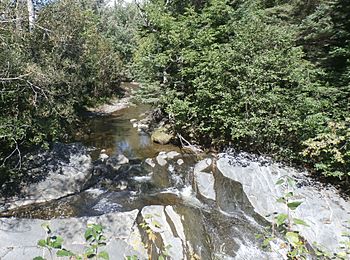
La Petite Rivière (Lac Saint-François) upstream of the Rang Saint-Michel bridge in Lambton.
|
|
| Country | Canada |
| Province | Quebec |
| Region | Chaudière-Appalaches |
| MRC | Le Granit Regional County Municipality |
| Municipality | Lambton |
| Physical characteristics | |
| Main source | Forest streams Lambton 463 m (1,519 ft) 45°49′11″N 71°03′49″W / 45.819801°N 71.063621°W |
| River mouth | Grand lac Saint François Lambton 289 m (948 ft) 45°50′41″N 71°06′44″W / 45.84472°N 71.11222°W |
| Length | 8.4 km (5.2 mi) |
| Basin features | |
| Progression | Grand lac Saint François, Saint-François River, St. Lawrence River |
La Petite Rivière (which means The Little River in English) is a small river in Quebec, Canada. It flows into the Grand lac Saint François, which is the starting point for the larger Saint-François River. This little river runs through the town of Lambton, located in the Le Granit Regional County Municipality in the Estrie region, near the St. Lawrence River.
Contents
Where La Petite Rivière Flows
This river is surrounded by other waterways:
- North: The rivière aux Bluets (Grand lac Saint François) and rivière aux Bluets Sud.
- East: The rivière aux Bluets (Grand lac Saint François) and Champagne stream.
- South: The Sauvage River (Felton River tributary), de la Languette brook, and Rouge brook.
- West: The Grand lac Saint François.
The River's Beginning
La Petite Rivière starts in a farming area. It begins east of Lambton village. This source is south of Route 108. It is also west of the 4th rang road. The river's starting point is near the head of Champagne brook. Champagne brook is a small stream that flows into the rivière aux Bluets (Grand lac Saint François).
The River's Journey
From its start, the river flows for about 2.1 kilometers (1.3 miles) north. Then, it turns northwest. It follows the 4th rang road for another 2.1 kilometers (1.3 miles). After that, it flows westward for 2.0 kilometers (1.2 miles). During this part, it crosses under Route 108. This crossing is about 1.7 kilometers (1.1 miles) north of downtown Lambton.
Next, the river travels southwest for 1.5 kilometers (0.9 miles). Here, it meets a small stream that runs through Lambton village. Finally, it flows westward for 0.7 kilometers (0.4 miles). It passes under the Rang Saint-Michel bridge. Most of the river's path is through farmland. However, its source and some small parts are in forested areas.
The River's End
La Petite Rivière ends in a small bay. This bay is on the east side of Grand lac Saint François. It is west of the center of Lambton village. The river's mouth faces "Pointe Richard," which is on the lake's west shore. It is also about 3.5 kilometers (2.2 miles) north of where Ruisseau Rouge enters the lake. Ruisseau Rouge is located south of Grand lac Saint François.
What's in a Name?
The name "La Petite Rivière" means "The Little River." This name was officially recorded on August 4, 1969. It was registered by the Commission de toponymie du Québec. This commission is responsible for naming places in Quebec.
 | May Edward Chinn |
 | Rebecca Cole |
 | Alexa Canady |
 | Dorothy Lavinia Brown |

