La Quemada facts for kids
|
La Quemada
|
|

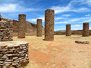
Salón de las Columnas
|
|
| Location | Villanueva Municipality, Zacatecas, Mexico |
|---|---|
| History | |
| Periods | 300 to 1200 AD |
| Cultures | Chalchihuites |
| Site notes | |
| Management | Instituto Nacional de Antropología e Historia |
| Website | Zona Arqueológica La Quemada |
La Quemada is an amazing ancient site in Mexico. It's a place where archaeologists study the past. You can find it in the Villanueva Municipality of Zacatecas, about 56 kilometers (35 miles) south of the city of Zacatecas.
Contents
Discovering La Quemada's Past
Because La Quemada is far from the main ancient cities of Mesoamerica (a historical region in Central America), experts have many ideas about its history. They have tried to link it to different ancient cultures.
What Was La Quemada?
Some people thought La Quemada might be the legendary Chicomostoc. This was a mythical place where the Aztec people stayed during their long journey. Others believed it was a fort for the Teotihuacán people. It might have even been a trading post for the Toltec culture. Another idea is that it was a city built by local groups living north of the Río Grande de Santiago.
In the 1600s, a historian named Fray Juan de Torquemada suggested La Quemada was a stop for the Aztecs. He thought they left older people and children here. Later, in the 1700s, Francisco Javier Clavijero also connected it to Chicomostoc. This led to the idea that La Quemada was the mythical "Seven Caves."
When Did La Quemada Thrive?
Archaeologists have been studying La Quemada since the 1980s. They found that the city grew between 300 and 1200 AD. This was during the Classical and early Postclassical periods. It existed at the same time as the Chalchihuites culture. This culture was known for its mining activities.
La Quemada, along with other sites like Las Ventanas and El Ixtepete, was part of a big trade network. This network connected northern Zacatecas to the Valley of Mexico. It even linked to the powerful city of Teotihuacán between 350 and 700 AD.
The Teotihuacán people likely traded with local leaders. They might have formed alliances or had merchants living in these centers. This helped move important goods like minerals, salt, shells, and obsidian.
Between 700 and 1100 AD, La Quemada became a very important trade center in its region. It started to compete with nearby sites. During this time, the city became more like a fortress. A large wall was built on the north side, about four meters (13 feet) high and wide. Some stairways were also removed to make it harder for people to move around inside. This shows it was built for defense.
Why is it Called "The Burnt City"?
Archaeologists have found signs of fire in many parts of the site. This suggests the city was destroyed in a violent event. This destruction by fire is why it's called la (ciudad) quemada, which means "the burnt city."
Exploring the Ancient City
La Quemada is built on a hill. It has many platforms of different sizes made of masonry (stone or brickwork). These platforms were the foundations for buildings. On the south and southeast sides, you can see many ceremonial buildings. Some of these have sunken patios and altar-pyramids, which are common in Mesoamerican architecture.
On the west side, there are platforms that seem to have been homes. All the buildings at La Quemada were made from rhyolite slabs. This is a type of volcanic rock found nearby.
To build the walls, workers used a special mortar made of clay and plant fibers. Over time, this mortar wears away, causing the walls to crumble. The walls were also covered with layers of clay stucco. Today, only a few pieces of this original finish remain.
Studies show that the city was built in different stages. New structures were often built over older ones. La Quemada is a unique archaeological site because of its many roads and smaller sites connected to it.
Main Buildings and Areas
The archaeological zone has three main parts: the "Ciudadela" (Citadel), the "Palace," and the "Temple." The Ciudadela has a long wall around the north side.
Salón de las Columnas (Columns Hall)
This large room is about 41 by 32 meters (135 by 105 feet). It was probably over five meters (16 feet) tall before a fire destroyed it. Inside, eleven columns held up the roof. We don't know its exact purpose, but studies suggest it was used for important ceremonies.
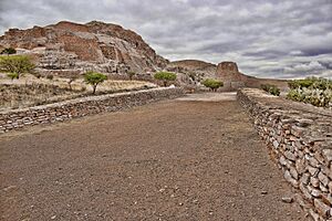
Calzada Mayor (Main Avenue)
This wide road stretches for about 400 meters (1,300 feet). Many smaller roads branch off from it, crossing the Malpaso Valley. To build this road, stone walls were made on the sides. Then, the space between the walls was filled with stone slabs and covered with clay and pebbles. This road is very impressive for its size. There are also signs of two altars at its main entrance. Recent studies have found over 170 kilometers (105 miles) of roads connecting La Quemada to other smaller sites!
Juego de Pelota (Ballgame Court)
This structure looks like the letter "I" and is typical of Mesoamerican ballcourts. It's built on a huge platform and measures 70 by 15 meters (230 by 49 feet). The side walls were very thick, like those in the Columns Hall.
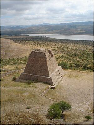
Pirámide Votiva (Votive Pyramid)
This pyramid is over 10 meters (33 feet) tall. Its steep sides make it stand out. In 1995, parts of a stairway were found on its south side. The middle and top parts of the pyramid have fallen over time. Originally, the stairway led to the top, where there was likely a room or temple made of materials that didn't last.
Escalinata (Stairway)
About 30 meters (98 feet) west of the Votive Pyramid, this stairway was found. It was the main way to reach the higher levels of the site. It was built in two stages. The first stage was round. The second stage was built over the first and reached a walkway on the second level. At some point, this main stairway was blocked off with a wall, probably for defense.
Muralla (The Wall)
This protective wall is very impressive. It's four meters (13 feet) high and three meters (10 feet) thick. It's located along the edges of the cliffs on the north and northeast sides of the site. This wall was likely built towards the end of La Quemada's time. It shows how much the people wanted to protect their city.
Ciudadela (Citadel)
Located at the highest point of the site, the Ciudadela has several buildings. These were probably used for ceremonies and defense.
Pirámide de los Sacrificios (Pyramid of Offerings)
This structure is also known as Structure and Terrace 18. It is believed that important ceremonies and offerings to the gods were conducted here.
Visiting the Site Museum
There's a museum right at the archaeological zone. Its design blends in with the landscape and the ancient buildings. It uses the same stone slabs and stucco found at the site. The museum shows how the region developed over time. It has a model of the site and videos about other ancient settlements in Zacatecas, like Loma San Gabriel and Chalchihuites.
See also
 In Spanish: La Quemada para niños
 | Audre Lorde |
 | John Berry Meachum |
 | Ferdinand Lee Barnett |


