
La Tortuga Island facts for kids
|
Native name:
Isla La Tortuga
|
|
|---|---|

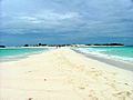
A beach on La Tortuga island
|
|
| Geography | |
| Location | Caribbean Sea |
| Coordinates | 10°55′54″N 65°18′29″W / 10.93167°N 65.30806°W |
| Major islands | 1 |
| Area | 156.60 km2 (60.46 sq mi) |
| Highest elevation | 45 m (148 ft) |
| Highest point | Altos de Garambeo |
| Administration | |
| Federal dependencies of Venezuela | |
La Tortuga Island, also known as Isla La Tortuga, is a large island in Venezuela. Its name means "the turtle" in Spanish, because many sea turtles come here to lay their eggs. It's the biggest island in a group called the Federal Dependencies of Venezuela. This group also includes smaller islands like Tortuguillos and Cayo Herradura. La Tortuga Island is about 156 square kilometers in size.
Island History
Long ago, before Europeans arrived, native people from Venezuela's coast visited La Tortuga Island. They came to gather natural resources like salt, fish, and turtles. We don't know which European explorer first saw and named the island. However, its name comes from the many sea turtles that lay their eggs on its long, sandy beaches each year.
Dutch and Spanish Conflicts
Between 1624 and 1638, people from the Netherlands (Dutch) visited the island during certain seasons. They came to collect salt from the salt ponds on the east side of the island. To protect their salt works, they built a fort. The Spanish Empire wanted to keep the Dutch away from the island.
In 1638, the Spanish finally forced the Dutch to leave. The Spanish governor of Cumaná, Benito Arias Montano, led his forces to destroy the Dutch facilities. They also flooded the salt ponds.
Since that time, La Tortuga Island has mostly remained empty. Only fishermen visit the island during certain seasons. Today, some tourists also come to enjoy the island's natural beauty.
Gallery
.jpg)
.jpg)
.jpg)


Images for kids
-
Cayo Herradura, a small island near La Tortuga.

See also
 In Spanish: Isla La Tortuga para niños
