
La Uvita facts for kids
Quick facts for kids
La Uvita
|
||
|---|---|---|
|
Municipality and town
|
||

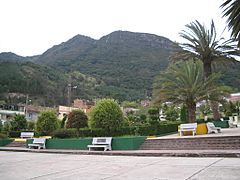
Central square of La Uvita
|
||
|
||

Location of the municipality and town of La Uvita in the Boyacá Department of Colombia
|
||
| Country | ||
| Department | Boyacá Department | |
| Province | Northern Boyacá Province | |
| Founded | 24 December 1758 | |
| Founded by | Vicente Ferrer del Río de Loza | |
| Elevation | 2,700 m (8,900 ft) | |
| Population
(2015)
|
||
| • Municipality and town | 2,523 | |
| • Urban | 1,018 | |
| Time zone | UTC-5 (Colombia Standard Time) | |
.svg)
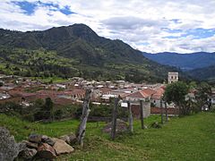
La Uvita is a small town and municipality in Colombia. It is located in the Boyacá Department, high up in the Andes mountains. The town sits about 2,700 meters (8,858 feet) above sea level. La Uvita shares its borders with several other towns. These include San Mateo to the north, El Cocuy and Chita to the east, and Jericó and Boavita to the south and west.
Contents
What's in a Name?
The name La Uvita comes from the ancient Chibcha language. In Chibcha, it means "meadow of fertile farmlands." This name shows how important farming was to the area.
A Look Back in Time
La Uvita was officially founded on December 24, 1758. It was started by a person named Vicente Ferrer del Río de Loza. The town was created as a safe place for people from a nearby town called Boavita. They needed a new place to live because of conflicts with the local indigenous people.
How People Make a Living
The main way people in La Uvita earn money is by making cheese. The town is known for its delicious dairy products. La Uvita also serves as a gateway for tourists. Many visitors come here before heading to the beautiful El Cocuy National Park. This park is famous for its stunning mountains and natural beauty.
Weather in La Uvita
The climate in La Uvita is cool because it's so high up in the mountains. Here's a quick look at the average weather:
| Climate data for La Uvita (Cusagui), elevation 2,950 m (9,680 ft), (1981–2010) | |||||||||||||
|---|---|---|---|---|---|---|---|---|---|---|---|---|---|
| Month | Jan | Feb | Mar | Apr | May | Jun | Jul | Aug | Sep | Oct | Nov | Dec | Year |
| Mean daily maximum °C (°F) | 19.2 (66.6) |
19.8 (67.6) |
19.2 (66.6) |
17.7 (63.9) |
17.6 (63.7) |
17.2 (63.0) |
16.5 (61.7) |
17.0 (62.6) |
17.4 (63.3) |
17.5 (63.5) |
17.2 (63.0) |
18.4 (65.1) |
17.9 (64.2) |
| Daily mean °C (°F) | 12.7 (54.9) |
12.6 (54.7) |
12.7 (54.9) |
12.8 (55.0) |
12.8 (55.0) |
12.3 (54.1) |
11.8 (53.2) |
12.0 (53.6) |
12.1 (53.8) |
12.3 (54.1) |
12.5 (54.5) |
12.8 (55.0) |
12.4 (54.3) |
| Mean daily minimum °C (°F) | 7.7 (45.9) |
7.9 (46.2) |
8.4 (47.1) |
9.0 (48.2) |
9.0 (48.2) |
8.6 (47.5) |
8.2 (46.8) |
8.2 (46.8) |
8.2 (46.8) |
8.5 (47.3) |
8.6 (47.5) |
8.1 (46.6) |
8.3 (46.9) |
| Average precipitation mm (inches) | 35.4 (1.39) |
53.7 (2.11) |
88.2 (3.47) |
145.5 (5.73) |
110.8 (4.36) |
55.3 (2.18) |
55.9 (2.20) |
53.7 (2.11) |
75.0 (2.95) |
133.0 (5.24) |
113.8 (4.48) |
59.2 (2.33) |
979.5 (38.56) |
| Average precipitation days (≥ 1.0 mm) | 7 | 9 | 13 | 17 | 18 | 16 | 19 | 18 | 15 | 19 | 17 | 10 | 177 |
| Average relative humidity (%) | 75 | 75 | 77 | 80 | 81 | 80 | 80 | 79 | 79 | 81 | 83 | 78 | 79 |
| Source: Instituto de Hidrologia Meteorologia y Estudios Ambientales | |||||||||||||
Images for kids
-
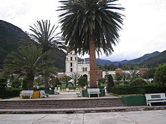
Central square
-
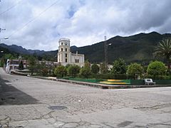
Central square and church
-
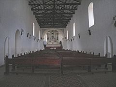
Church interior
-
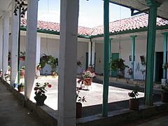
Andalusian patio


-
Monserrate Hill
-
Tabor Hill
-
Rural road


See Also
 In Spanish: La Uvita para niños
