Lac à la Carpe facts for kids
Quick facts for kids Lac à la Carpe |
|
|---|---|
| Location | Belle-Rivière |
| Coordinates | 48°13′10″N 71°51′44″W / 48.21944°N 71.86222°W |
| Lake type | Natural |
| Primary inflows | (clockwise from the mouth) Décharge du lac Larouche, décharge du lac au Canard. |
| Primary outflows | discharge going to rivière à la Carpe |
| Basin countries | Canada |
| Max. length | 8.3 km (5.2 mi) |
| Max. width | 2.0 km (1.2 mi) |
| Surface elevation | 359 m (1,178 ft) |
The Lac à la Carpe (which means "Carp Lake" in English) is a very important freshwater lake in Quebec, Canada. It's the biggest lake in the area that feeds into the Rivière à la Carpe. This river then flows into Lac Saint-Jean, a much larger lake.
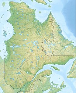
Lac à la Carpe is found in a wild, unorganized area called Belle-Rivière. It's also close to the northern edge of the Laurentides Wildlife Reserve.
The area around the lake is mostly covered by forests. Forest work, like cutting trees, is the main activity here. People also visit for fun activities like fishing or hiking. A forest road runs along the east side of the Métabetchouane River, making it easier to reach the lake.
Usually, the surface of Lac à la Carpe freezes over from early December until the end of March. It's generally safe to walk or play on the ice from mid-December to mid-March.
About the Lake's Location
Lac à la Carpe is surrounded by other rivers and lakes. Knowing these helps us understand where its water comes from and where it goes.
Here are some of the main water bodies nearby:
- To the north: The Rivière à la Carpe and Lac Saint-Jean.
- To the east: Lac de la Belle Rivière, La Belle Rivière, and Grand lac des Cèdres.
- To the south: The Métabetchouane River and rivière aux Canots.
- To the west: The Métabetchouane River and a smaller lake called petit lac à la Carpe.
Lac à la Carpe is about 8.3 kilometres (5.2 mi) long and 2.0 kilometres (1.2 mi) wide. It sits at an elevation of about 359 metres (1,178 ft) above sea level. The lake has a cool peninsula that sticks out towards the northwest. This creates a small bay where water from "Lac au Canard" flows in.
How Water Flows Through the Lake
The main water sources for Lac à la Carpe are the discharges from Lac au Canard and Lac Madore, which flow in from the southeast. Water also comes from Lac Larouche.
The water leaves Lac à la Carpe from its northwest side, at the end of a small bay. From there, the water travels quite a journey:
- It flows about 3.6 kilometres (2.2 mi) north to join the Rivière à la Carpe.
- Then, it travels about 11.8 kilometres (7.3 mi) west down the Rivière à la Carpe.
- Next, it goes about 19.1 kilometres (11.9 mi) north along the Métabetchouane River until it reaches the south shore of Lac Saint-Jean.
- The water then crosses Lac Saint-Jean, moving about 22.8 kilometres (14.2 mi) to the northeast.
- Finally, it flows about 172.3 kilometres (107.1 mi) east along the Saguenay River until it reaches Tadoussac. Here, it joins the huge Saint Lawrence estuary, which leads to the Atlantic Ocean!
Name of the Lake
The name "Lac à la Carpe" was officially recognized on December 5, 1968. This was done by the Commission de toponymie du Québec, which is a group in Quebec responsible for naming places.
 | Selma Burke |
 | Pauline Powell Burns |
 | Frederick J. Brown |
 | Robert Blackburn |


