
Lairet River facts for kids
Quick facts for kids Lairet River |
|
|---|---|
| Country | Canada |
| Province | Quebec |
| Region | Capitale-Nationale |
| Regional County Municipality | Quebec City (sector "Limoilou") |
| Physical characteristics | |
| Main source | Lairet Canal Quebec (city) (sector "Limoilou") 46°49′31″N 71°14′26″W / 46.82528°N 71.24056°W |
| River mouth | Rivière Saint-Charles Quebec (city) (sector "Limoilou") 10 m 46°49′26″N 71°14′20″W / 46.82389°N 71.23889°W |
| Length | 0.3 km (0.19 mi) |
The Lairet River is a small waterway in Quebec City, Quebec, Canada. It is a tributary, which means it flows into a larger river, the Saint-Charles River. The Lairet River used to be over two kilometers long. It started near Charlesbourg and wound its way through the Limoilou area.
Today, most of the Lairet River flows underground in pipes. This change happened in the 1960s. However, a small part of the river was brought back to the surface in 2008.
Contents
The Lairet River's Journey
The Lairet River is the last tributary on the north side of the Saint-Charles River. The Saint-Charles River then flows into the mighty Saint-Laurent River. Long ago, the Lairet River was much longer, stretching for many kilometers.
It began north of an old area called seigniory Saint-Ignace. From there, it flowed southeast into Limoilou. In Limoilou, the river became wider and had many small bends, like a snake.
A Look Back: History of the Lairet River

The Lairet River has a long and interesting history. On September 14, 1535, a famous French explorer named Jacques Cartier saw the river for the first time. Cartier and his crew spent the winter near where the Lairet River meets the Saint-Charles River. This spot was close to a village called Stadaconé, where the St. Lawrence Iroquoians lived.
The name "Rivière de Lairet" first appeared on a document in 1626. Over the years, it was called different names, like "Rivière de Larray" and even "Jacques-Cartier river." This last name might have come from a fort built by the Jesuits near the river's mouth. For a long time, the river flowed naturally through farmland.
The River Goes Underground
As the Limoilou area grew and became more industrial in the early 1900s, many factories and buildings were built near the Lairet River. Sadly, in these busy areas, the river slowly became very polluted. Its winding path also made it hard to build straight streets.
Because of these problems, people asked for the river to be put into pipes. On March 15, 1960, work began to channel the river underground. This big project happened in three stages, finishing by 1967. The river was completely hidden, flowing under the Cartier-Brébeuf National Historic Site before joining the Saint-Charles River. This was part of a larger project to line the banks of the Saint-Charles River with concrete, which finished in the 1970s.

Bringing the River Back
In the 2000s, parts of the underground pipes in Cartier-Brébeuf Park collapsed. Around the same time, Quebec City started to remove the concrete walls from the Saint-Charles River and restore its natural banks.
As part of this effort, about 300 meters (almost 1,000 feet) of the Lairet River's pipeline was removed. This brought a section of the river back to the surface where it meets the Saint-Charles River. However, most of the Lairet River still flows underground today. Even the Saint-François d'Assise hospital, which was built near the river, sometimes has problems with water leaking in from the hidden river.
Images for kids
-

The Lairet River in 1887, by Bunnett -
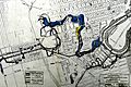
A plan for the Lairet River pipeline from 1943 -
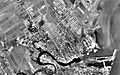
Limoilou from above in 1948, before the river was fully hidden


