Lake Alabaster / Wāwāhi Waka facts for kids
Quick facts for kids Lake Alabaster / Wāwāhi Waka |
|
|---|---|

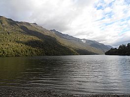
Lake Alabaster at the Hollyford Track, New Zealand.
|
|
| Location | South Island |
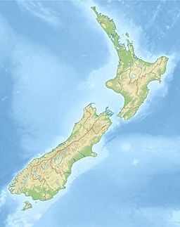
| Coordinates | 44°31′S 168°10′E / 44.517°S 168.167°E |
| Primary inflows | Pyke River |
| Primary outflows | Pyke River |
| Basin countries | New Zealand |
| Max. length | 6 km (3.7 mi) |
| Surface area | 7 km2 (2.7 sq mi) |
Lake Alabaster / Wāwāhi Waka is a beautiful lake in the southwest of New Zealand's South Island. It's also known by its Māori name, Wāwāhi Waka. Sometimes, people call it Waiwahuika too. This lake is found at the northern end of a special area called Fiordland.
The lake stretches about six kilometres long. It covers an area of about seven square kilometres. Lake Alabaster runs from the northeast to the southwest.
About Lake Alabaster
Lake Alabaster is part of the Hollyford River system. It's one of two lakes in this area. The other lake is called Lake McKerrow.
The Pyke River Connection
The Pyke River is very important to Lake Alabaster. Water flows into the lake from the Pyke River. Then, the Pyke River also flows out of the lake. This means the same river feeds the lake and drains it. The Pyke River is a smaller stream that eventually joins the larger Hollyford River.
How the Lake Was Formed
Lake Alabaster was created a long, long time ago. It formed at the end of a valley that was carved out by a huge glacier. Imagine a giant river of ice slowly moving and shaping the land. That's what a glacier does!
If the ocean level had been a little higher back then, this lake might have been connected to the sea. It could have been the northern part of what people call McKerrow Fiord.
Exploring the Area
A famous walking path called the Hollyford Track goes along the eastern side of Lake Alabaster. This track is one of New Zealand's most popular places for tramping, which is like a long walk or hike. Many people enjoy exploring the stunning nature around the lake.
 | Audre Lorde |
 | John Berry Meachum |
 | Ferdinand Lee Barnett |


