Lake Argyle facts for kids
Quick facts for kids Lake Argyle |
|
|---|---|

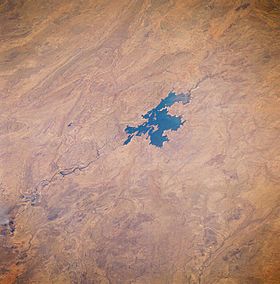
Lake Argyle seen from space, August 1985. The main channel of the Ord River (dark, meandering feature) north of the lake is visible as it drains northward, eventually emptying into the Joseph Bonaparte Gulf. Low, folded mountains can be identified east and west of this river valley.
|
|
| Lua error in Module:Location_map at line 416: Malformed coordinates value. | |
| Location | near Kununurra East Kimberley, Western Australia |
| Coordinates | Lua error in Module:Coordinates at line 614: attempt to index field 'wikibase' (a nil value). |
| Type | Freshwater reservoir |
| Primary inflows | Ord River, Bow River |
| Primary outflows | Ord River |
| Catchment area | 46,100 km2 (17,800 sq mi) |
| Basin countries | Australia |
| First flooded | 1971 |
| Max. length | 67 kilometres (42 mi) |
| Max. width | 10 kilometres (6.2 mi) |
| Surface area | 703 km2 (271 sq mi) |
| Water volume | 10,763 gigalitres (8.726×10⁶ acre⋅ft; 2.582 cu mi) |
| Official name: Lakes Argyle and Kununurra | |
| Designated: | 7 June 1990 |
| Reference #: | 478 |
Lake Argyle is a huge man-made freshwater lake in Western Australia. It is the second largest man-made freshwater lake in Australia by how much water it can hold. This giant lake is part of a big farming project called the Ord River Irrigation Scheme. You can find it near the town of Kununurra in the East Kimberley region.
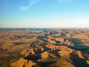
The lake covers a huge area on the Kimberley Plateau. It is about 80 kilometers (50 miles) inland from the Joseph Bonaparte Gulf. The main river flowing into Lake Argyle is the Ord River. The Bow River and many other smaller creeks also feed the lake. Lake Argyle is listed as an important wetland. In 1990, Lake Argyle and Lake Kununurra became protected under an international agreement called the Ramsar Convention. A famous diamond mine, the Argyle mine, was located here from 1985 until 2020. It produced a massive 865 million carats of diamonds!
Contents
Building Lake Argyle
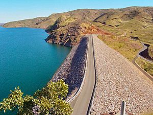
The Ord River Dam was finished in 1971 by a company called Dravo Corporation. The dam was officially opened the next year. The dam wall is 335 meters (1,099 feet) long and 98 meters (322 feet) high. This earth-fill dam wall is very efficient. It stores a huge amount of water compared to its size. The lake got its name from a property called Argyle Downs, which was partly covered by the new lake.
In 1996, the spillway wall was made 6 meters (20 feet) taller. This change doubled the amount of water the dam could hold. The dam also received a special award called a Historic Engineering Marker. This award was given by Engineers Australia to recognize its importance in engineering history.
Lake Argyle's Size and Features
Lake Argyle usually covers an area of about 1,000 square kilometers (386 square miles). It can hold about 10,763 gigaliters (GL) of water. To give you an idea, 1 GL is 1 billion liters! The lake filled up completely in 1973. Its spillway flowed continuously until 1984.
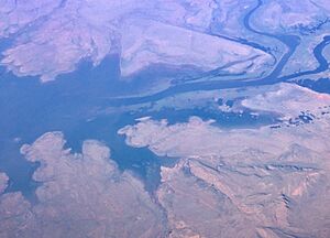
Lake Argyle's normal storage volume is 5,797 GL. This makes it the largest reservoir in Australia. If there was a maximum flood, Lake Argyle could hold an incredible 35,000 GL of water. At this level, it would cover an area of 2,072 square kilometers (800 square miles). Higher areas of land have become permanent islands within the lake.
Farming with Lake Argyle's Water
Lake Argyle is a key part of the Ord River Irrigation Scheme. This project helps farmers grow crops in the East Kimberley region. Currently, about 150 square kilometers (58 square miles) of farmland use water from the lake.
The original plan was to use the dam's water to grow rice for export. However, this plan didn't work out. Waterfowl, especially magpie geese, ate the rice plants too quickly. Now, other crops are grown instead. Even with these farms, Lake Argyle is still considered Australia's most under-used lake. This means it has the potential to help grow even more food.
Animals and Plants of Lake Argyle
Building the dam and creating Lake Argyle changed the environment a lot. The amount of water flowing into the Ord River has been greatly reduced. However, a brand new and thriving ecosystem has grown within Lake Argyle itself. The lake is recognized as an important wetland area. It is protected under the Ramsar Convention along with Lake Kununurra.
The lake is now home to 26 different kinds of native fish. It also has a large population of freshwater crocodiles, estimated to be around 25,000! Some of the fish you can find here include barramundi, southern saratoga, archer fish, and sleepy cod. While mostly freshwater crocodiles live here, sometimes a saltwater crocodile might be seen. Unfortunately, cane toads reached the dam in late 2008. Their numbers grew a lot during the summer of 2009.
Birds of Lake Argyle
Lake Argyle is a very important place for birds. It has been named an Important Bird Area (IBA) by BirdLife International. This is because it supports about 150,000 waterbirds. Twelve different species of waterbirds live here in large enough numbers to be important worldwide.
The muddy areas and grasslands around the lake are natural homes for many wading birds. Eight species of waders are found here in internationally significant numbers. There is also a healthy population of Australian bustards, which are a "near threatened" species.
Birds for which the lake is globally important include magpie geese, wandering whistling-ducks, green pygmy-geese, and black-necked storks. You can also see Australian pelicans, black swans, and wedge-tailed eagles. Smaller birds like the spinifex pigeon and budgerigar are common. Mid-sized birds like the blue-winged kookaburra also live here.
Some challenges for the birds include invasive weeds and animals like the cane toad. Farming activities and feral animals like cattle can also cause problems. These animals might eat too much grass in the shallow areas of the lake. Experts suggest building fences to keep these animals out of the important shallow parts of the lake.


