
Lake Flannigan facts for kids
Quick facts for kids Lake Flannigan |
|
|---|---|
| Big Lake (1886–1911) | |

Lake Flannigan
Location in Tasmania
|
|
| Location | King Island, Tasmania |
| Coordinates | 39°37′05″S 143°57′25″E / 39.618°S 143.957°E |
| Etymology | Michael John Flannigan |
| Basin countries | Australia |
| Max. length | 2 km (1.2 mi) |
| Max. width | 1.5 km (0.93 mi) |
| Surface area | 150 ha (370 acres) |
Lake Flannigan is a natural freshwater lake located on King Island, Tasmania, Australia. It sits about 4 kilometers (2.5 miles) south of the Cape Wickham Lighthouse in a northern area called Wickham.
At around 150 hectares (370 acres), Lake Flannigan is the biggest body of water on King Island. Its size can change a lot depending on the weather. When there's a lot of rain, the lake can stretch almost 2 kilometers (1.2 miles) long and be up to 1.5 kilometers (0.9 miles) wide in some spots.
The bottom of the lake is about 15.25 meters (50 feet) above sea level. The depth of the water itself has varied greatly over the years. For example, it was reported to be 9.1 meters (30 feet) deep in 1887, but only 2 meters (6.6 feet) deep in 2007. This was after a long dry period and because some drainage had been wrongly directed into the lake.
You can see Lake Flannigan from Springs Road to the south and Cape Wickham Road to the east.
Contents
Protecting Lake Flannigan

Even though private farms surround Lake Flannigan, the lake itself is Crown land. This means it's land owned by the government. Part of its southeastern shore is even set aside as a "Public Reserve," which is land kept for public use.
Scientists say that Lake Flannigan is a "complex dune barrage lake." This means it formed because sand dunes blocked water, creating the lake. The water from the lake drains underground to a place called The Springs, which is about 1.3 kilometers (0.8 miles) west on the coast. The amount of water in the lake is affected by the types of rocks and sand around it, like limestone, quartz sand, granite hills, and sand dunes. Natural events like waves and strong winds also cause erosion, which can change the lake's water levels.
Since Michael John Flannigan first surveyed King Island in 1896, people have known that the lake needed some protection. Flannigan worried that if people built too close to the lakes, it would harm the natural balance of the island.
The land around Lake Flannigan was first officially protected in 1913. The government announced that the lake shores would become a safe place for wild birds. Later, in 2005, a report suggested that the lake could be made into a Nature Reserve. This would help protect the area while still allowing farmers to access water for their animals if needed.

Lake Flannigan is also a very important place for birds. The King Island Biodiversity Management Plan 2012–2022 identified it as a habitat for the Orange-bellied parrot (Neophema chrysogaster). These rare parrots use the lake area as a resting spot each year. They stop there from mid-March to June on their way to Victoria, and again briefly in September when they return.
How Lake Flannigan Got Its Name
The way places in Tasmania got their official names has changed over time. Before 1956, names were often given by walking clubs or government groups like the Mines Department. These names were loosely managed by the Surveys Office, while local councils named streets and parks.
Lake Flannigan has had a few different names over the years, including Big Lake and Lake Dobson.
Big Lake

The people living on King Island originally called Lake Flannigan "Big Lake." In 1887, a group of scientists called the Field Naturalists Club of Victoria visited the island. They wrote many reports about their trip. During their visit, they decided to rename Big Lake to "Lake Dobson." They did this to honor Dr. Dobson, who had helped their exploration party a lot.
Dr. Dobson was Frank Dobson, a politician from Victoria who was the president of the Field Naturalists Club of Victoria in 1884.
However, it seems the Field Naturalists didn't manage to convince the islanders or the government in Hobart to use their new name. The name Big Lake continued to be used until 1911. You can see this on an official map of King Island from that year. On the 1911 map, the name "Lake Flannigan" is written over the erased original name, which was "Big Lake." This was a common practice back then: old maps were updated many times until a new map was needed. So, it looks like the lake was still known as Big Lake in 1911.
Lake Dobson

The plan by the Victorian Field Naturalists to rename King Island's Big Lake to Lake Dobson in 1887 never actually happened.
Instead, in 1953, the name Lake Dobson was officially given to a different body of water. This Lake Dobson is located in the Mount Field National Park on mainland Tasmania. It was named after Henry Dobson, a well-known Tasmanian lawyer and politician who started the Tourist Association.
Lake Flannigan
Even though the Lands Department didn't officially name places in Tasmania before 1956, some of its staff were very interested in names. We don't know exactly who decided to name the lake after Flannigan, but it might have been some of his colleagues:
- Hall: In 2006, a writer named Smith mentioned that Leventhorpe Hall, a chief mapmaker, was interested in Aboriginal words for new towns. He might have helped name the lake after his friend Flannigan, even after he retired.
- Harrisson: Kenneth Montague Harrisson, another surveyor, also worked on King Island like Flannigan. He was known for being excited about naming places as he surveyed them.
- Hurst: William Nevin Tatlow Hurst was a colleague and close friend of Flannigan's. He often spoke and wrote about how places in Tasmania were named, especially around 1911. Hurst was even acting as the Surveyor-General for a few months in 1911.

Michael John Flannigan surveyed King Island many times starting in 1895. He even bought some land there. In 1899, he became the permanent District Surveyor for the island. Sadly, he became very ill and had to leave the island in 1901. He returned to his family in Bendigo, Victoria, and passed away from tuberculosis in April 1901 at the age of 38.
By 1913, Lake Flannigan was permanently named in his honor.
The name "Big Lake" was then given to a different, previously unnamed lagoon. This lagoon is located near the Colliers Swamp Conservation Area, in the very south of King Island, in an area called Surprise Bay.
Water Bodies on King Island
King Island has many sources of fresh water, though some of them dry up at certain times of the year.
There are 45 lakes and lagoons spread across the island.
| A – E | G – Pi | Pj – Z |
|---|---|---|
| Attrills Lagoon | George Lagoon | Porky Lagoon |
| Bertie Lagoon | Granite Lagoon | Ridge Lagoon |
| Big Lake | Lake Flannigan | Sam Lagoon |
| Bob Lagoon (Game Reserve) | Lake Martha Lavinia | Seal Rocks Lagoon |
| Bungaree Lagoon (Conservation Area) | Lake Wickham | Shearing Shed Lagoons |
| Cask Lake | Lily Lagoon (Nature Reserve) | Snake Hole |
| Chain of Lagoons | Little Cask Lake | Stick Lagoon |
| Clevelands Lagoon | Long Lagoon | Sullivans Lagoon |
| Corduroy Lake | Manresa Lagoon | Swan Lagoon |
| Dead Sea | Meatsafe Lagoon | Tathams Lagoon (Conservation Area) |
| Deep Lagoons (Conservation Area) | Mimi Lagoon | Three Tree Lagoon |
| Denbys Lagoons | Muddy Lagoon (Nature Reserve) | Wallaby Lagoon |
| Dry Lagoon (Conservation Area) | Pearshape Lagoon | White Beach Lagoon |
| Duck Ponds | Pennys Lagoon | Woodland Lagoon |
| Egg Lagoon (drained) | Pioneer Lagoon | Yellow Rock Lagoon |
Images for kids
-
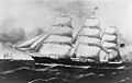
The Netherby was wrecked on King Island in July 1866.
-

Wickham Lighthouse and quarters, King Island. Only the lighthouse remains.
-
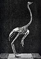
King Island Emu skeleton: A specimen of the extinct Dromaeus ater discovered in the Royal Zoological Museum, Florence.
-
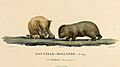
Illustration of the now extinct wombat of King Island, by Charles-Alexandre Lesueur.
-
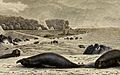
Elephant seals, ‘’Dromaius novaehollandiae minor’’, on King Island in former times.
.jpg)


