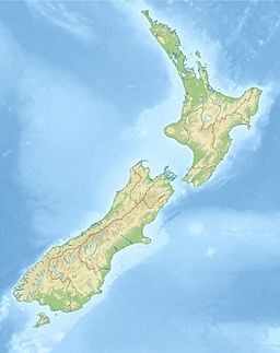
Lake Hawdon (New Zealand) facts for kids
Quick facts for kids Lake Hawdon |
|
|---|---|
| Location | Canterbury, New Zealand |
| Coordinates | 43°06′15″S 171°51′00″E / 43.10417°S 171.85000°E |
| Primary inflows | Lake Marymere |
| Primary outflows | Slovens Stream |
| Max. length | 1,000 metres (3,300 ft) |
| Max. width | 450 metres (1,480 ft) |
| Surface area | 30 hectares (74 acres) |
| Surface elevation | 579 metres (1,900 ft) |
Lake Hawdon is a beautiful small lake located in the high country of Canterbury, New Zealand. It is a popular spot for fishing and enjoying nature.
About Lake Hawdon
This lake is found about 130 kilometers (about 80 miles) northwest of Christchurch. It is part of a group of lakes that feed into the Waimakariri River system.
Location and Size
Lake Hawdon is connected to another nearby lake called Lake Marymere. Water from Lake Marymere flows into Lake Hawdon. From Lake Hawdon, the water then flows into Slovens Stream. This stream eventually joins the Broken River, which is a tributary of the Waimakariri River.
The lake sits high up, at an elevation of 579 meters (about 1,900 feet) above sea level. It is about 1,000 meters (3,280 feet) long and 450 meters (1,476 feet) wide. The total surface area of the lake is about 30 hectares (74 acres). To the west of the lake, you can see the peak of Mount St Bernard.
Fishing Fun
Lake Hawdon is a favorite place for people who enjoy fly fishing. You can find two types of fish here: brown trout and rainbow trout. Many anglers visit the lake to try and catch these fish.
Getting There
The small town of Craigieburn is located just east of Lake Hawdon. If you want to visit the lake, you can get there by following a walking track. This track starts from Craigieburn Road.
How it Got its Name
Lake Hawdon was named after Joseph Hawdon. He was a land owner in the Canterbury region during the 1800s.
 | Georgia Louise Harris Brown |
 | Julian Abele |
 | Norma Merrick Sklarek |
 | William Sidney Pittman |


