
Lake Mahinerangi facts for kids
Quick facts for kids Lake Mahinerangi |
|
|---|---|

Lake Mahinerangi
|
|

Lake Mahinerangi
Location in Otago peninsula
|
|
| Location | Clutha District, Otago Region, South Island |
| Coordinates | 45°52′S 169°57′E / 45.867°S 169.950°E |
| Lake type | reservoir |
| Basin countries | New Zealand |
| Max. length | 12 km (7.5 mi) |
Lake Mahinerangi is a big lake in New Zealand. It was made by building a dam across the Waipori River. This dam helps create electricity using the power of water! You can find it about 35 kilometers (22 miles) west of Dunedin city, on New Zealand's South Island. Work on the dam started way back in 1903, and it has been making power since 1907.
Contents
How the Lake Got Its Name
The lake got its name from a girl called Dorothy Kathleen Mahinerangi Burnett. Her dad, William Burnett, was the mayor of Dunedin city in 1911 and 1912.
Lake Mahinerangi is about 12 kilometers (7.5 miles) long. It sits on the west side of a place called Maungatua, near the Berwick Forest. The area around the lake has farms, grassy fields, and planted forests.
Lake Branches
At its southern end, Lake Mahinerangi has two main 'arms' or branches. They are called Loch Luella and Loch Loudon.
Fishing Fun
If you like fishing, Lake Mahinerangi is a good spot! It has lots of brown trout and some perch. The lake is nearly 600 meters (2,000 feet) high. This means it can get very windy and cold. So, fishing is usually best during the warmer months of the year.
Wind Power Near the Lake
The Mahinerangi Wind Farm is located just north of Lake Mahinerangi. This wind farm, run by Trustpower, uses large wind turbines to create even more clean electricity for New Zealand.
Images for kids
-
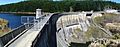
Mahinerangi Dam
