Lake Mykee Town, Missouri facts for kids
Quick facts for kids
Lake Mykee Town, Missouri
|
|
|---|---|
|
Village
|
|

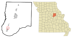
Location of Lake Mykee Town, Missouri
|
|
| Country | United States |
| State | Missouri |
| County | Callaway |
| Area | |
| • Total | 0.25 sq mi (0.65 km2) |
| • Land | 0.19 sq mi (0.49 km2) |
| • Water | 0.06 sq mi (0.16 km2) |
| Elevation | 824 ft (251 m) |
| Population
(2010)
|
|
| • Total | 350 |
| • Estimate
(2016)
|
354 |
| • Density | 1,400/sq mi (538/km2) |
| Time zone | UTC-6 (Central (CST)) |
| • Summer (DST) | UTC-5 (CDT) |
| FIPS code | 29-39990 |
| GNIS feature ID | 2398382 |
| Website | www.lakemykee.com |
Lake Mykee Town was a small village in Callaway County, Missouri, United States. It was once a separate community. However, its local government officially ended on June 1, 2017. The area then became part of Holts Summit, Missouri. This means Lake Mykee Town no longer exists as its own village. The land is now considered part of Holts Summit. In 2010, about 350 people lived there. It was also part of the larger Jefferson City area.
Contents
About Lake Mykee Town
Location and Size
Lake Mykee Town was a small place. It covered about 0.65 square kilometers (0.25 square miles). Most of this area was land, about 0.49 square kilometers (0.19 square miles). The rest was water, around 0.16 square kilometers (0.06 square miles).
How Lake Mykee Got Its Name
The Hasselman family developed Lake Mykee. They built the community on their old family farm. The name "Mykee" is special. It comes from combining parts of their two sons' names.
Changes to Highway 54
In the 1970s, a major road called Highway 54 was expanded. This expansion happened east of the lake and dam. The new route helped avoid cutting off the community's entrance. It also kept the highway away from the lake itself.
People and Homes
| Historical population | |||
|---|---|---|---|
| Census | Pop. | %± | |
| 1980 | 188 | — | |
| 1990 | 257 | 36.7% | |
| 2000 | 326 | 26.8% | |
| 2010 | 350 | 7.4% | |
| 2016 (est.) | 354 | 1.1% | |
| U.S. Decennial Census | |||
New Neighborhoods Nearby
In 2004, a new neighborhood started to be built. It was called Southwind Meadows. This area was south of Lake Mykee. It was developed on land owned by the Payne family since 1928. Streets for the first 24 homes were built in 2004 and 2005. By the end of 2007, five houses were almost finished. By 2019, 19 homes had been built and people were living in them. This neighborhood has electricity, gas, water, and its own sewer system.
Population in 2010
In 2010, there were 350 people living in the village. These people lived in 131 households. A household is a group of people living together. Most households, 107 of them, were families.
The village was mostly made up of White residents (96.9%). There were also small numbers of African American (0.6%) and Asian (0.9%) residents. Some people (1.7%) were from two or more racial backgrounds. About 1.4% of the population was Hispanic or Latino.
Most households (73.3%) were married couples living together. About 30.5% of households had children under 18. A small number of households had a single parent. About 14.5% of homes had just one person living there. The average household had about 2.67 people.
The average age of people in the village was 43.7 years old. About 22% of residents were under 18. About 16.9% were 65 years old or older. The village had slightly more males (51.7%) than females (48.3%).
See also
 In Spanish: Lake Mykee Town para niños
 | Kyle Baker |
 | Joseph Yoakum |
 | Laura Wheeler Waring |
 | Henry Ossawa Tanner |

