Lake Nippenicket facts for kids
Quick facts for kids Lake Nippenicket |
|
|---|---|

Lake Nippenicket
|
|
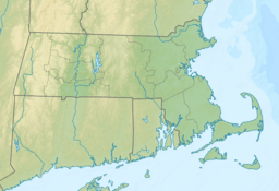
| Location | Plymouth and Bristol County, Massachusetts, U.S. |
| Coordinates | 41°58′19″N 71°02′28″W / 41.97194°N 71.04111°W |
| Type | Natural freshwater pond |
| Basin countries | United States |
| Surface area | 354 acres (143 ha) |
| Average depth | 3 ft (0.91 m) |
| Max. depth | 6 ft (1.8 m) |
| Surface elevation | 56 ft (17 m) |
| Settlements | Bridgewater, Massachusetts |
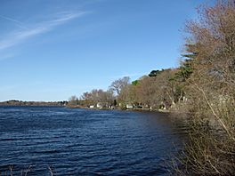
Lake Nippenicket, often called The Nip by local people, is a natural freshwater pond. It is located in the town of Bridgewater, Massachusetts. Part of the lake also touches Raynham, Massachusetts.
Contents
About Lake Nippenicket
Lake Nippenicket is a cool spot to explore. It's a freshwater pond, which means its water is not salty like the ocean. The lake is quite shallow, with a maximum depth of about 6 feet (1.8 meters).
Where is The Nip?
You can find Lake Nippenicket near some major roads. It's close to Route 104. It's also not far from where I-495 and Route 24 meet. This makes it easy to get to!
Part of a Bigger Water System
Lake Nippenicket is an important part of the Taunton River Watershed. A watershed is like a big bowl where all the rain and snowmelt drain into a common river or lake. Water from Lake Nippenicket flows into the Town River. From there, it joins the larger Taunton River.
A big part of the lake is also included in the Hockomock Swamp Wildlife Management Area. This area is a special place where nature is protected. It's a great spot for animals and plants to live safely.
How Did It Get Its Name?
The name Nippenicket comes from a Native American tribe. This tribe used to live in the area around the lake. It's a way to remember the first people who lived on this land.
 | Stephanie Wilson |
 | Charles Bolden |
 | Ronald McNair |
 | Frederick D. Gregory |


