
Lake Tekapo Airport facts for kids
Quick facts for kids
Lake Tekapo Airport
|
|||||||||||
|---|---|---|---|---|---|---|---|---|---|---|---|

The airport terminal in 2014
|
|||||||||||
| Summary | |||||||||||
| Airport type | Private | ||||||||||
| Operator | Air Safaris Ltd | ||||||||||
| Serves | Lake Tekapo | ||||||||||
| Elevation AMSL | 2,496 ft / 760 m | ||||||||||
| Coordinates | 44°00′18″S 170°26′37″E / 44.0049°S 170.4436°E | ||||||||||
| Runway | |||||||||||
|
|||||||||||
Lake Tekapo Airport is a small airport located about 1.5 miles (2.4 km) west of the town of Lake Tekapo. You can find it in the Mackenzie District of the South Island in New Zealand. This airport was built in 1974 by a company called Air Safaris. They use it mainly for special flights that take people on amazing tours over the Southern Alps mountains.
What Happens at the Airport?
This airport is private, which means it's not a big international airport. Planes here mostly stay on the paved runways and taxiways. The runway has special markings that only Air Safaris pilots use for their flights.
Safety Tips for Pilots
Pilots flying into Lake Tekapo Airport need to be careful. There's a main highway near one end of the runway (Runway 11). Pilots must make sure they fly high enough to stay clear of the road. Also, there's another helicopter landing area (heliport) about 1.5 miles southwest of the airport. Pilots need to know where it is to avoid any problems.
Night Flights
The airport has special LED lights that can be turned on in an emergency. However, flying at night is usually only allowed for Air Safaris pilots who have special training. This helps keep everyone safe.
Fuel for Planes
Planes at Lake Tekapo Airport can get fuel using a special swipe card system. They offer two types of fuel: AVGAS and Jet A1. These are different kinds of fuel used by various types of aircraft.
Gallery
- Lake Tekapo Airport
-
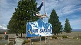
The sign on the highway by the Lake Tekapo Airport, 2014
-
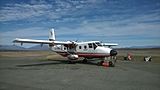
Air Safaris Gaf Nomad at Lake Tekapo Airport, 2014
-
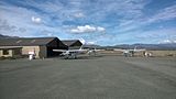
View of Apron at the Lake Tekapo airport, 2014


