Lambs Grove, Iowa facts for kids
Quick facts for kids
Lambs Grove, Iowa
|
|
|---|---|

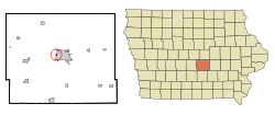
Location of Lambs Grove, Iowa
|
|
| Country | |
| State | |
| County | Jasper |
| Area | |
| • Total | 0.10 sq mi (0.26 km2) |
| • Land | 0.10 sq mi (0.26 km2) |
| • Water | 0.00 sq mi (0.00 km2) |
| Elevation | 919 ft (280 m) |
| Population
(2020)
|
|
| • Total | 174 |
| • Density | 1,705.88/sq mi (659.37/km2) |
| Time zone | UTC-6 (Central (CST)) |
| • Summer (DST) | UTC-5 (CDT) |
| ZIP code |
50208
|
| Area code(s) | 641 |
| FIPS code | 19-42870 |
| GNIS feature ID | 0458212 |
Lambs Grove is a small city in Jasper County, Iowa, United States. It's a quiet place with a population of 174 people, according to the 2020 Census. This number is a bit smaller than the 225 people who lived there in 2000.
Contents
Where is Lambs Grove Located?
Lambs Grove is found at coordinates 41°42′4″N 93°4′42″W / 41.70111°N 93.07833°W. This means it's in the central part of the United States.
The city covers a total area of about 0.26 square kilometers (0.10 square miles). All of this area is land. A small creek flows through Lambs Grove, and there's a place called Hat Rock Park near the center of town.
History of Lambs Grove
Lambs Grove was started in 1927 by E. C. and Jennie Ogg. They named the town after Jennie Ogg's father, Richard Lamb. The city officially became a city on December 29, 1952.
On March 5, 2022, a strong tornado passed through Lambs Grove. Even though the tornado was not as strong as it had been in other areas, it still caused damage to several homes and buildings in the city.
Population and People
Lambs Grove is a small community. Let's look at how its population has changed over the years.
| Historical populations | ||
|---|---|---|
| Year | Pop. | ±% |
| 1960 | 234 | — |
| 1970 | 239 | +2.1% |
| 1980 | 228 | −4.6% |
| 1990 | 212 | −7.0% |
| 2000 | 225 | +6.1% |
| 2010 | 172 | −23.6% |
| 2020 | 174 | +1.2% |
| Source: and Iowa Data Center Source: |
||
What the 2020 Census Shows
In 2020, there were 174 people living in Lambs Grove. These people lived in 73 households, and 56 of these were families. The city had about 659 people per square kilometer (1,702 people per square mile).
Most of the people in Lambs Grove were White (94.8%). A small number were Black or African American (1.1%), Native American (0.6%), or from two or more races (2.3%). About 6.3% of the population identified as Hispanic or Latino.
In terms of households, about 35.6% had children under 18 living there. Most households (58.9%) were married couples living together. The average age of people in the city was 49.6 years old. About 20.1% of residents were under 20 years old, and 23.6% were 65 years or older. The number of males and females was almost equal, with 50.0% male and 50.0% female.
What the 2010 Census Showed
In 2010, Lambs Grove had 172 people living there. There were 73 households and 52 families. The population density was about 664 people per square kilometer (1,720 people per square mile).
Most of the people were White (95.9%). About 2.9% were from other races, and 1.2% were from two or more races. About 2.9% of the population was Hispanic or Latino.
About 24.7% of households had children under 18. The average age in the city was 47.5 years. About 20.3% of residents were under 18, and 20.3% were 65 or older. The city had slightly more females (51.2%) than males (48.8%).
See also

- In Spanish: Lambs Grove (Iowa) para niños
 | Delilah Pierce |
 | Gordon Parks |
 | Augusta Savage |
 | Charles Ethan Porter |

