Lancaster, Tennessee facts for kids
Quick facts for kids
Lancaster, Tennessee
|
|
|---|---|

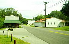
Intersection of Highway 141 and Maple Street in Lancaster
|
|
| Country | United States |
| State | Tennessee |
| County | Smith |
| Elevation | 531 ft (162 m) |
| Population
(2010)
|
|
| • Total | 363 |
| Time zone | UTC-6 (Central (CST)) |
| • Summer (DST) | UTC-5 (CDT) |
| ZIP code |
38569
|
| Area code(s) | 615/629 |
| GNIS feature ID | 1290568 |
Lancaster is a small place in Smith County, Tennessee, United States. It is known as an unincorporated community. This means it's a settled area that doesn't have its own local government, like a city or town would. Instead, it's governed by the county.
Lancaster is located about 5.3 miles (8.5 kilometers) southeast of another town called Gordonsville.
About Lancaster
Location and Geography
Lancaster is found along State Highway 141. This highway connects it to Gordonsville and Center Hill Lake. The area gets its water from Smith Fork, which is a small river that flows into the Caney Fork. A "tributary" is a stream or river that flows into a larger stream or river.
Population and Post Office
In 2010, the population of the area around Lancaster's zip code was 363 people. A zip code tabulation area is a special area created by the U.S. Census Bureau that roughly matches a postal ZIP code.
Lancaster used to have its own post office. It had the ZIP code 38569. However, this post office closed on March 4, 2011. It was part of a plan by the United States Postal Service to close smaller post offices across the country.
A Bit of History
The community of Lancaster is named after an early settler. His name was John Lancaster, Jr. He came to this area in the late 1700s. His family still owns a farm in the area today. This farm has a special title: it's a "Tennessee Century Farm." This means the farm has been owned by the same family for at least 100 years!
 | Frances Mary Albrier |
 | Whitney Young |
 | Muhammad Ali |


