Langdon, North Dakota facts for kids
Quick facts for kids
Langdon, North Dakota
|
|
|---|---|

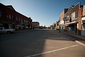
Business district of Langdon
|
|

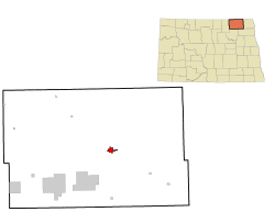
Location of Langdon, North Dakota
|
|
| Country | United States |
| State | North Dakota |
| County | Cavalier |
| Founded | 1885 |
| Incorporated | February 25, 1888 |
| Area | |
| • Total | 1.579 sq mi (4.090 km2) |
| • Land | 1.547 sq mi (4.007 km2) |
| • Water | 0.032 sq mi (0.082 km2) |
| Elevation | 1,611 ft (491 m) |
| Population
(2020)
|
|
| • Total | 1,909 |
| • Estimate
(2023)
|
1,847 |
| • Density | 1,194.0/sq mi (461.0/km2) |
| Time zone | UTC–6 (Central (CST)) |
| • Summer (DST) | UTC–5 (CDT) |
| ZIP Code |
58249
|
| Area code(s) | 701 |
| FIPS code | 38-44780 |
| GNIS feature ID | 1036117 |
| Highways | ND 1, ND 5 |
| Sales tax | 7.0% |
Langdon is a city located in Cavalier County, North Dakota, in the United States. It is the main town, or county seat, for Cavalier County. In 2020, about 1,909 people lived there. Langdon became the county seat in 1884, was officially started in 1885, and became an incorporated city on February 25, 1888.
Contents
History of Langdon
A post office has been open in Langdon since 1886. The city was named after Robert Bruce Langdon, who was a politician (someone involved in government) and a railroad official.
In 1887, several towns, including Langdon, wanted to be the county seat. This meant they wanted to be the main town where the county government was located. Stories say that some people voted multiple times by simply changing their hats and coats! Even with these tricks, Langdon won the vote and remained the county seat.
On Memorial Day in 1909, a powerful tornado, nicknamed "The Vulcan," hit near Langdon. It traveled about seven miles and caused a lot of damage. Five people lost their lives, and 29 were hurt. This tornado was part of a bigger storm system called the "Decoration Day Massacre," which was the second deadliest tornado outbreak in North Dakota's history.
There are some amazing stories from that day. One woman, Mrs. M.L. Sullivan, ran to her cellar for safety. When the winds stopped, she was standing in the cellar, holding her broken doorknob! Another person, Katie Diamond, was lifted high into the air, even above trees and telephone poles. She was then dropped into a yard, almost completely unharmed. The tornado destroyed many buildings, including barns and parts of the railroad.
Langdon also experienced some very cold weather in the winter of 1935–36. For 75 days in a row, the temperature never got above freezing (32°F or 0°C). For 32 of those days, the high temperature was colder than -20°F (-29°C)!
Geography
Langdon covers a total area of about 1.579 square miles (4.090 square kilometers). Most of this area is land, with a small part being water.
Population and People
| Historical population | |||
|---|---|---|---|
| Census | Pop. | %± | |
| 1890 | 291 | — | |
| 1900 | 1,188 | 308.2% | |
| 1910 | 1,214 | 2.2% | |
| 1920 | 1,228 | 1.2% | |
| 1930 | 1,221 | −0.6% | |
| 1940 | 1,546 | 26.6% | |
| 1950 | 1,838 | 18.9% | |
| 1960 | 2,151 | 17.0% | |
| 1970 | 2,182 | 1.4% | |
| 1980 | 2,335 | 7.0% | |
| 1990 | 2,241 | −4.0% | |
| 2000 | 2,101 | −6.2% | |
| 2010 | 1,878 | −10.6% | |
| 2020 | 1,909 | 1.7% | |
| 2023 (est.) | 1,847 | −1.7% | |
| U.S. Decennial Census 2020 Census |
|||
How Many People Live Here?
The United States Census Bureau counts the population every ten years. In 2020, Langdon had 1,909 people living in 862 households. A household is a group of people living together in one home.
Most of the people in Langdon are White (93.1%). There are also smaller numbers of Native American, Asian, and people of two or more races. About 1.8% of the population is Hispanic or Latino.
| Race | Number | Percent |
|---|---|---|
| White (NH) | 1,777 | 93.1% |
| Black or African American (NH) | 0 | 0.0% |
| Native American (NH) | 15 | 0.8% |
| Asian (NH) | 9 | 0.5% |
| Pacific Islander (NH) | 0 | 0.0% |
| Some Other Race (NH) | 7 | 0.4% |
| Mixed/Multi-Racial (NH) | 67 | 3.5% |
| Hispanic or Latino | 34 | 1.8% |
| Total | 1,909 | 100.0% |
In 2010, the city had 1,878 people. The population density was about 1,138 people per square mile (440 people per square kilometer). This tells us how crowded an area is.
The average age of people in Langdon in 2010 was 50.1 years old. About 19.1% of residents were under 18, and 28.5% were 65 or older.
Education
Langdon's high school changed its name to "Langdon Area High School" in 2001. This happened because some schools in nearby areas closed, and their students joined Langdon's school. The official mascot for Langdon Area High School is the Cardinal.
Students at Langdon Area Schools often do better than the average for the whole state of North Dakota. For example, their graduation rates are usually higher. Since 2005, Langdon students have performed better in many areas, sometimes by a lot!
For instance, in the 2007–2008 school year, the goal for math skills was 65.5%, but Langdon students actually achieved 97.7%. This shows how well they were doing! Their attendance rates are also usually higher than the state average.
Local Media
Langdon has four radio stations that are based in the city. These stations are KNDK (AM), KLME, KAOC, and KYTZ, and they are all owned and operated by Simmons Broadcasting.
Climate
Langdon has a climate with big temperature changes between seasons. Summers are warm to hot and often humid, while winters are very cold. This type of climate is called a warm-summer humid continental climate.
The city was hit by a strong tornado in May 1909, as mentioned earlier.
| Climate data for Langdon, North Dakota (1991–2020 normals, extremes 1897–present) | |||||||||||||
|---|---|---|---|---|---|---|---|---|---|---|---|---|---|
| Month | Jan | Feb | Mar | Apr | May | Jun | Jul | Aug | Sep | Oct | Nov | Dec | Year |
| Record high °F (°C) | 52 (11) |
59 (15) |
77 (25) |
97 (36) |
111 (44) |
106 (41) |
112 (44) |
102 (39) |
103 (39) |
91 (33) |
74 (23) |
64 (18) |
112 (44) |
| Mean maximum °F (°C) | 34.4 (1.3) |
35.0 (1.7) |
48.3 (9.1) |
69.5 (20.8) |
82.8 (28.2) |
85.9 (29.9) |
86.6 (30.3) |
89.9 (32.2) |
85.1 (29.5) |
74.3 (23.5) |
51.7 (10.9) |
37.6 (3.1) |
91.9 (33.3) |
| Mean daily maximum °F (°C) | 12.5 (−10.8) |
17.1 (−8.3) |
29.8 (−1.2) |
48.0 (8.9) |
63.5 (17.5) |
71.9 (22.2) |
76.6 (24.8) |
76.5 (24.7) |
67.3 (19.6) |
50.9 (10.5) |
32.3 (0.2) |
18.2 (−7.7) |
47.1 (8.4) |
| Daily mean °F (°C) | 3.7 (−15.7) |
7.6 (−13.6) |
20.9 (−6.2) |
37.8 (3.2) |
51.9 (11.1) |
61.7 (16.5) |
66.2 (19.0) |
65.1 (18.4) |
55.7 (13.2) |
40.7 (4.8) |
24.0 (−4.4) |
10.2 (−12.1) |
37.1 (2.8) |
| Mean daily minimum °F (°C) | −5.0 (−20.6) |
−2.0 (−18.9) |
12.0 (−11.1) |
27.6 (−2.4) |
40.4 (4.7) |
51.6 (10.9) |
55.8 (13.2) |
53.8 (12.1) |
44.0 (6.7) |
30.6 (−0.8) |
15.7 (−9.1) |
2.2 (−16.6) |
27.2 (−2.7) |
| Mean minimum °F (°C) | −27.6 (−33.1) |
−24.4 (−31.3) |
−11.7 (−24.3) |
10.9 (−11.7) |
25.6 (−3.6) |
39.0 (3.9) |
44.2 (6.8) |
41.7 (5.4) |
28.8 (−1.8) |
14.8 (−9.6) |
−3.1 (−19.5) |
−19.8 (−28.8) |
−29.8 (−34.3) |
| Record low °F (°C) | −50 (−46) |
−51 (−46) |
−40 (−40) |
−15 (−26) |
6 (−14) |
24 (−4) |
30 (−1) |
28 (−2) |
— | −7 (−22) |
−31 (−35) |
−42 (−41) |
−51 (−46) |
| Average precipitation inches (mm) | 0.45 (11) |
0.36 (9.1) |
0.59 (15) |
1.14 (29) |
3.13 (80) |
4.17 (106) |
3.44 (87) |
2.45 (62) |
2.11 (54) |
1.52 (39) |
0.75 (19) |
0.64 (16) |
20.75 (527) |
| Average snowfall inches (cm) | 8.2 (21) |
6.1 (15) |
6.1 (15) |
4.4 (11) |
1.2 (3.0) |
0.0 (0.0) |
0.0 (0.0) |
0.0 (0.0) |
0.0 (0.0) |
2.6 (6.6) |
8.1 (21) |
10.6 (27) |
47.3 (120) |
| Average precipitation days (≥ 0.01 in) | 7.5 | 5.4 | 6.1 | 5.9 | 11.1 | 12.9 | 10.8 | 9.3 | 8.4 | 7.8 | 6.4 | 7.3 | 98.9 |
| Average snowy days (≥ 0.1 in) | 7.6 | 5.5 | 4.5 | 1.9 | 0.4 | 0.0 | 0.0 | 0.0 | 0.0 | 1.4 | 5.2 | 7.4 | 33.9 |
| Source: NOAA | |||||||||||||
Langdon, North Dakota, was at the center of a very cold period in 1936. It stayed below freezing (0°F or -18°C) for 92 days in a row, from November 30 to February 29. The warmest temperature in February was a chilly 15°F (-9°C)!
Langdon also holds the record for the most consecutive days below 0°F (-18°C) in the connected United States. This record is 41 days in a row, from January 11 to February 20.
See also
 In Spanish: Langdon (Dakota del Norte) para niños
 | Valerie Thomas |
 | Frederick McKinley Jones |
 | George Edward Alcorn Jr. |
 | Thomas Mensah |


