
Langeoog facts for kids
Quick facts for kids
Langeoog
|
|||
|---|---|---|---|

Aerial view of Langeoog from the north
|
|||
|
|||
|
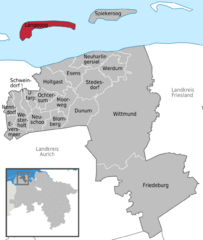
Location of Langeoog within Wittmund district
 |
|||
| Lua error in Module:Location_map at line 530: Unable to find the specified location map definition: "Module:Location map/data/Germany Niedersachsen" does not exist. | |||
| Country | Germany | ||
| State | Lower Saxony | ||
| District | Wittmund | ||
| Area | |||
| • Total | 19.67 km2 (7.59 sq mi) | ||
| Elevation | 5 m (16 ft) | ||
| Population
(2022-12-31)
|
|||
| • Total | 1,747 | ||
| • Density | 88.82/km2 (230.03/sq mi) | ||
| Time zone | UTC+01:00 (CET) | ||
| • Summer (DST) | UTC+02:00 (CEST) | ||
| Postal codes |
26465
|
||
| Dialling codes | 04972 | ||
| Vehicle registration | WTM | ||
| Website | www.langeoog.de | ||


Langeoog (Low German: Langeoog) is one of seven islands in the East Frisian Islands group. These islands are located in the North Sea, next to the Wadden Sea in northern Germany. Langeoog is found between the islands of Baltrum (to its west) and Spiekeroog (to its east). It is also a small town, or municipality, in the Wittmund area of Lower Saxony, Germany. The name Langeoog means Long Island in the local Low German language.
Contents
Discovering Langeoog's Geography
Langeoog has a long beach that stretches for about 14 km (9 mi). The actual size of the island can change a bit depending on the tide. The tide is the regular rise and fall of the sea, which goes up and down by about 2.5 metres (8 ft 2.4 in) every six hours.
How Langeoog Was Formed
Langeoog is mostly made of sand. When rainwater falls on the island, it sinks into the sand. This fresh water is lighter than the salty ocean water. Because of this, a "bubble" of fresh water floats above the salt water both around and deep under the island.
Changes to the Island's Shape
The sea slowly wears away the beach and sand dunes on the western side of Langeoog. Since around 1970, the western end of Langeoog has moved several hundred meters towards the east. This natural process happens on all the East Frisian islands. Some islands have moved so much that towns had to be rebuilt many times! To help stop this erosion, most East Frisian islands (except Juist and Langeoog) have large concrete walls called groynes at their western ends.
A Look at Langeoog's Past
Langeoog has a rich history, including challenges from nature and difficult times during wars.
Major Storms and Floods
In 1717, a very strong storm, known as the Christmas storm tide, hit Langeoog. This powerful storm was so strong that it broke the island into three separate pieces.
Life During the Nazi Era
During the time of Nazi Germany, the government started to build up Langeoog as an air base in 1940. Many people were forced to work on the island. For example, 250 French prisoners of war were brought to Langeoog in August 1940. Later, in 1941, 113 Soviet prisoners of war also arrived. Sadly, many of these prisoners died due to very harsh conditions. Today, a special memorial at the Langeoog Dunes Cemetery remembers them.
Even before the war, in the 1930s, the island hosted summer camps for the Hitler Youth, a Nazi youth organization. During this same period, a Jewish family named Heer, who had been forced from their home, lived on the island. They were joined by a group of Jewish children from Halberstadt who were hiding. Brave sisters from a place called Haus Bethanien secretly cared for them.
Notable People Who Lived or Died Here
- The expert on ancient Iranian languages, Christian Bartholomae, passed away on the island in 1925.
- The meteorologist Johannes Letzmann lived on Langeoog from 1962 until he died in 1971.
Getting Around Langeoog

.jpg)
To reach Langeoog, you can take a ferry from the port of Bensersiel on the mainland. The Langeoog Shipping Company operates several ferries, including Langeoog I, Langeoog II, Langeoog III, and Langeoog IV. Unlike many other ferries in the East Frisian Islands, Langeoog's ferry schedule does not depend on the tide. This makes planning your trip easier.
Once you arrive, a railway connects the port to the main town. Langeoog also has its own airport.
No Cars Allowed!
Langeoog has a special rule: most cars are not allowed on the island! Visitors must leave their cars on the mainland. Only emergency vehicles, like the fire department and ambulance, use regular motorized cars. Tractors and heavy construction vehicles can be used for specific jobs. Police officers and doctors usually get around on bicycles. Some businesses, like construction companies, drink delivery services, and the post office, use electric cars. If you don't want to walk, you can rent a bicycle or even take a horse-drawn carriage taxi!
Langeoog's Tourism and Economy
Tourism is the most important part of Langeoog's economy. Most buildings on the island offer rooms for guests, and there are several hotels. There is also a youth hostel located a few kilometers outside the main town.
The island's clean air is a big draw for visitors, especially those who have breathing problems.
Famous Places to See
Langeoog has several interesting landmarks that visitors enjoy exploring.

- Langeoog's water tower: This tall tower helps provide fresh water to the island.
- The towers of the Catholic and Protestant churches: These church towers are important parts of the island's skyline.
- The Melkhörndüne: This sand dune was once the highest natural point in East Frisia. However, so many visitors walked to the top that the sand shifted. Now, the White Dune on the nearby island of Spiekeroog is the highest point.
- The Seenotbeobachtungsstelle: This is a watchtower used by the lifeboat service to keep an eye on the sea and help anyone in trouble.
Well-Known People from Langeoog
The famous singer-songwriter Lale Andersen lived on Langeoog for several years. Her 1939 version of the song Lili Marleen became incredibly popular during World War II. Even though she passed away in Vienna in 1972, she is buried in the island's dune cemetery. A bronze memorial has been placed on Langeoog to honor her.
See also
 In Spanish: Langeoog para niños
