Lankaran-Astara Economic Region facts for kids
Quick facts for kids
Lankaran-Astara Economic Region
|
|
|---|---|

Lankaran–Astara Economic Region in Azerbaijan
|
|
| Country | Azerbaijan |
| Area | |
| • Total | 6,070 km2 (2,340 sq mi) |
| Population
(2021)
|
|
| • Total | 953,600 |
| • Density | 157.10/km2 (406.9/sq mi) |
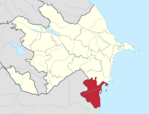
The Lankaran-Astara Economic Region is one of the 14 special economic areas in Azerbaijan. It's located in the southern part of the country. This region shares borders with Iran to the south and west. To the east, it meets the Caspian Sea.
To its north is the Shirvan-Salyan Economic Region. This area includes six different districts. These are Jalilabad, Astara, Lerik, Lankaran, Masally, and Yardimli. The total size of the region is about 6,070 square kilometers. In 2021, around 953,600 people lived here.
Contents
Geography of the Region
The main city in this region is Lankaran. The Lankaran-Astara region covers about 14% of Azerbaijan's total land. A large part of it, about 26%, is covered by forests. This region has a special damp subtropical climate. This makes it different from other parts of Azerbaijan.
The land here is split into two main parts. There's the flat Lankaran Lowland and the hilly Talysh Mountains. The mountains in the west include the Talysh, Peshtasar, and Burovar ranges.
Climate and Weather
The Talysh Mountains and the nearby Caspian Sea create a varied climate. Summers are usually hot and dry. The average temperature in July is about 24–26 °C. Winters are quite mild. The average temperature in January is around −2 to −4 °C. It snows for about 10 to 30 days each winter.
In the mountains, summers are cooler. The average July temperature is about 19–20 °C.
Rivers and Water
The region has many rivers. Most of these rivers get their water from rainfall. Several water reservoirs have been built on these rivers. These reservoirs help supply drinking water and water for farming. The Khanbulanchay reservoir, built in 1977, is the biggest one.
Soil Types
The Lankaran economic region has many different types of soil. In the Lankaran Lowland, you'll find mostly glacial-yellow soil. The plains and foothills have forest soil.
In the Talysh Mountains, there are brown mountain-forest soils. These soils are found at heights of 600–1200 meters. Yellow soils are unique to this region in Azerbaijan. They cover about 157,100 hectares. These soils are found in areas with a humid subtropical climate.
People of the Region
As of 2012, the Lankaran economic region had about 868,100 people. About a quarter of the people (24.9%) live in cities. The rest (75.1%) live in smaller towns and villages.
Natural Resources
This region is rich in natural resources. It has sand, clay, gravel, gypsum, and marble. There are also many mineral water springs and thick forests. About 25% of the forests are in Astara, 24% in Lerik, and 20% in Lankaran.
The forests are home to trees like Parrotia persica (ironwood), chestnut oak, and silk acacia.
Mineral Springs
There are about 20 mineral springs in the Astara district. Their water can be warm, from 35–50 °C. Many springs in the Lankaran area, like Lankaran and Nafthoni, have sulfur and other minerals. These are thought to have healing properties. Many mineral springs are also found in Masally, Lerik, and Yardimli districts. People use them for treatment.
Protected Areas
The Lankaran economic region is home to several important nature reserves. The Gizilaghaj Reserve is a winter home for many different birds. The Hirkan National Park and the Zuvand Reserve protect rare plants.
The Ghizil-Agaj State Reserve was set up in 1929. It covers 88,000 hectares. Birds like swans, geese, ducks, and herons are protected here. The Hirkan National Park was created in 1936. It has 2,900 hectares. This park protects old trees like ironwood and chestnut oak. The Zuvand Reserve is in the Yardimli district. It's 15,000 hectares and protects the mountain goat.
Economy and Work
The economy of the Lankaran-Astara region focuses on different areas.
Industry
Industry here is not as big as farming. It mainly processes local farm products. The food industry makes up 90% of all industrial goods. This includes businesses that make meat, milk, cheese, and bread. There are also companies that make building materials, furniture, and repair vehicles.
Most of the industrial goods (almost 90%) come from the Masally, Lankaran, and Astara regions.
Agriculture
The region is great for farming. It has a humid subtropical climate, water for irrigation, and good soil. Tea-growing is the most important type of farming. Other important crops include grain, vegetables, and grapes.
The Lankaran economic region produces 99% of all the tea in Azerbaijan. It also grows 27% of the country's vegetables and 15% of its grain. Farmers here also grow a lot of potatoes, grapes, and fruits. The flat areas of Lankaran, Masally, and Astara are known for tea, vegetables, and melons. The Jalilabad region is famous for its grapes. Growing citrus fruits is also very popular here.
Transportation
Goods and people are moved around using the Baku-Astara railway and motorway. These routes are also important for trade between Azerbaijan and Iran. In 2010, the amount of goods moved by road was 14 times more than in 2003. Passenger travel also increased a lot.
Life in the Region
Education
There are 566 schools in the Lankaran economic region. About 124,616 students attend these schools. The main university in the region is Lankaran State University. There are also secondary schools, a drama theater, and an ethnographic museum.
See also
 In Spanish: Lankaran-Astara (región económica) para niños
 | Jewel Prestage |
 | Ella Baker |
 | Fannie Lou Hamer |


