Yardimli District facts for kids
Quick facts for kids
Yardimli District
|
|
|---|---|

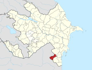
Map of Azerbaijan showing Yardimli District
|
|
| Country | |
| Region | Lankaran-Astara |
| Established | 8 August 1930 |
| Capital | Yardimli |
| Settlements | 88 |
| Area | |
| • Total | 670 km2 (260 sq mi) |
| Population
(2020)
|
|
| • Total | 68,000 |
| • Density | 101.5/km2 (263/sq mi) |
| Time zone | UTC+4 (AZT) |
| Postal code |
6500
|
Yardimli District (Azerbaijani: Yardımlı rayonu) is one of the 66 districts in Azerbaijan. It is located in the south-east part of the country. This district is part of the Lankaran-Astara Economic Region.
Yardimli District shares borders with other districts like Jalilabad, Masally, and Lerik. It also borders the Ardabil Province in Iran. The main city and capital of the district is Yardimli. In 2020, about 68,000 people lived in the district.
Contents
History of Yardimli District
The area we now know as Yardimli District was once called the village of Vargaduz. From 1920 to 1930, it was part of Lankaran Uyezd. In 1930, it became known as the Vargaduz district. Later, in 1938, it was officially renamed Yardimli region. The town of Yardimli became its center.
Exploring Yardimli's Geography
Yardimli District is a mountainous area in southeastern Azerbaijan. It shares a long border with Iran, stretching for 96 kilometers in the south and west. It also borders other Azerbaijani districts: Lerik District (40 km), Masally District (11 km), and Jalilabad District (20 km).
The district is home to parts of the Talysh Mountains. The highest peak here is Shahnishin Mountain, which is 2,490 meters (8,169 feet) tall. Other mountain ranges include Peshtasar (with a highest point of 2,244 meters or 7,362 feet) and Burovar.
The land in Yardimli District covers about 66,720 hectares. A large part of this, about 20,536 hectares, is covered by forests. The soil in the district is mostly mountain-forest-brown, brown-mountain-forest, and mountain-meadow types.
Rivers and Waterways
The Vilesh River is the longest and most important river in the district. It flows for 11 kilometers within the area. Other rivers like Allar, Peshtasar, Solgard, and Valishli are also important waterways in the region.
Plants and Animals
The forests of Yardimli are filled with many types of valuable trees. You can find beech, hornbeam, and oak trees. There are also bushes and rose hips.
These forests are home to various wild animals. Common animals include foxes, wolves, pigs, squirrels, jackals, and badgers. You might also spot wild cats and beech martens.
Yardimli's Climate
Yardimli District has a warm and generally humid climate. Winters are mild, and springs are warm. The average temperature throughout the year is about 11.9 degrees Celsius (53.4 degrees Fahrenheit). The district receives about 586 millimeters (23 inches) of rainfall each year. Winds usually come from the west-south direction.
People of Yardimli
Population Growth
The number of people living in Yardimli District has been growing steadily. In 2000, the population was around 50,000. By 2019, it had increased to 67,000 people. This is a big jump, showing an increase of about 34 percent.
Out of the total population in 2019, about 34,300 were men and 32,700 were women. A significant part of the population, over 29.6 percent (about 19,600 people), were young people and teenagers aged 14–29 in 2018.
Ethnic Groups
The people of Yardimli District are mostly Azerbaijanian. In 2009, nearly all of the population, about 99.99%, identified as Azerbaijanian. Other smaller groups, like Russians and Ukrainians, also live in the district.
Economy of Yardimli
The economy of Yardimli District has been growing. In 2015, the district produced goods and services worth 94.58 million manats. This was an 8.8% increase compared to the previous year. It was also more than 10 times higher than the production in 2003. This growth means that each person in the district produced more wealth.
Education in Yardimli
Yardimli District has many schools and educational places for children and young people. There are 80 secondary schools in total. These include:
- 42 full-time secondary schools
- 22 secondary schools
- 16 primary schools
The district also has 3 pre-schools for younger children. In addition, there are 5 out-of-school institutions, which offer activities and learning beyond regular school hours.
Gallery
See also
 In Spanish: Raión de Yardimli para niños
 | Audre Lorde |
 | John Berry Meachum |
 | Ferdinand Lee Barnett |


