
Lapstone Zig Zag facts for kids
Quick facts for kids Lapstone Zig Zag |
|
|---|---|
.jpg)
View from Emu Plains, New South Wales
|
|
| Overview | |
| Status | Main Western line subsequently diverted; this section closed |
| Owner | NSW Government Railways |
| Locale | Western Sydney, New South Wales, Australia |
| Coordinates | 33°45′52″S 150°38′22″E / 33.764569°S 150.639411°E |
| Termini | Knapsack Viaduct (east) Glenbrook Station (west) |
| Stations | Lucasville |
| Service | |
| Type | Heavy rail |
| System | NSW Government Railways |
| History | |
| Opened | 1867 |
| Closed | 18 December 1892 |
| Technical | |
| Number of tracks | Single |
| Character |
|
| Track gauge | 4 ft 8 1⁄2 in (1,435 mm) standard gauge |
| Highest elevation | c. 167 metres (548 ft) (Glenbrook (1st)) |
|
Invalid designation
|
|
Official name:
|
|
| Type: | Local heritage (built) |
| Designated: | 27 December 1991 |
| Reference #: | G024 |
| Type: |
|
| Category: | Transport - Land |
| Builder: | William Watkins |
The Lapstone Zig Zag was a special type of railway line. It was built between Emu Plains and Blaxland stations in New South Wales, Australia. This railway was needed to help trains climb the very steep eastern side of the Blue Mountains.
It was built between 1863 and 1865. The zig zag and the nearby Knapsack Viaduct were designed by John Whitton. He was the chief engineer for the New South Wales Government Railways. William Watkins was the builder. The Lapstone Zig Zag was the first zig zag railway ever built on a main railway line anywhere in the world!
The railway line was very steep, with a slope of 1 in 33. This means for every 33 metres forward, it went up 1 metre. One idea was to build a 3-kilometre-long tunnel through the Grose Valley. But this was too expensive for the colony at that time. The railway included the Knapsack Viaduct and a station called Lucasville, which opened in 1877. The zig zag closed in 1892. This happened when the main railway line was moved to a new route. Parts of the old line later became the Great Western Highway. Today, it is a popular walking track.
Contents
How the Lapstone Zig Zag Worked
A zig zag railway helps trains climb very steep hills. It does this by making the train go forwards, then backwards, then forwards again. This creates a "Z" shape on the side of the mountain.
When a train travelled west, it first crossed the Knapsack Viaduct. Then it went onto the "Bottom Road" of the Zig Zag. There was a point where the "Middle Road" branched off. This road went backwards and sharply upwards. The train would stop on the Bottom Road. Then it would reverse direction to climb the Middle Road.
Similarly, at the end of the Middle Road, the train would stop again. It would then reverse direction one more time. This allowed it to get onto the "Top Road" and continue its journey. Lucasville Station was built on the Top Road in 1877. This clever design helped trains conquer the steep Blue Mountains.
History of the Lapstone Zig Zag
Building the Railway (1860s)
William Watkins won the contract to build this railway in March 1863. This included the Knapsack Viaduct and the Lapstone Zig Zag. The work was finished in December 1865, about 18 months late. The railway officially opened for trains in 1867.
The line of the old track, now without rails, goes through impressive rock cuttings. You can see these on the walking track from Knapsack Street. There is also a stone culvert near Lucasville platform. A culvert is like a tunnel for water to flow under the track. This one was built to divert water deep under the railway.
Lucasville station was built in 1877. It was for John Lucas, who was the Minister for Mines. He had a holiday home nearby. To the west of the Top Road, you can still see low sandstone walls. These probably marked the edge of Lucasville estate and the railway land. The Zig Zag is mostly surrounded by bushland. It offers amazing views east towards Sydney. Walking here gives you a sense of what it was like to travel over the mountains long ago. At the start of the Top Road, you can find four old railway sleepers and metal spikes. These are all that's left of the original track.
Challenges and Changes
By 1867, the railway reached Wentworth Falls. But the Lapstone Zig Zag soon had problems. The length of the "points" (where tracks switch) limited how long trains could be. Also, it was a single track. This meant trains going in opposite directions had to wait at special crossing points. The first crossing point after Lapstone Zig Zag was at Wascoe's Siding, which is now Glenbrook station.
The idea for the zig zag came from Indian railways. John Whitton learned about a similar project in India. He adapted this idea to create the Lapstone Zig Zag. It was a huge achievement in railway engineering for its time.
The single track also led to a fatal accident in 1878 at Emu Plains. Two goods trains, one going east and one going west, crashed into each other. In 1890, signal boxes were built. These replaced the old system where workers had to use hand levers to change the tracks.
The Glenbrook Tunnel Deviation

The Commissioner of Railways, E. M. Eddy, decided the Zig Zag needed to be replaced. A new route, called the Glenbrook Deviation, was built. This new route included a tunnel. The Lapstone Zig Zag and Lucasville station officially closed on 18 December 1892. The rails were then removed.
However, the new Glenbrook Tunnel also had problems. It was built with the same steep slope as the Zig Zag. This caused train wheels to slip, especially when water leaked onto the tunnel floor. Smoke also became a big problem for trains going uphill, as the tunnel didn't have good ventilation.
The building of this tunnel is shown in Arthur Streeton's famous painting, Fire's On.
The Twentieth Century and Beyond
By 1910, the railway line was being duplicated. This means it was made into a double track. The old "rathole" tunnel was replaced by a new Glenbrook Tunnel in 1913. This new tunnel had a gentler slope.
After 1913, the lower part of the old track, including the Knapsack Gully Viaduct, was turned into a road. This road became part of the Great Western Highway. This was the main road up Lapstone hill until the M4 motorway replaced it in 1993.
The older Glenbrook tunnel was used for growing mushrooms. During World War II, from 1943 to 1946, the Royal Australian Air Force (RAAF) used it to store chemical weapons, like mustard gas. Today, you can explore the Lapstone Zig Zag, Knapsack Viaduct, the Old Glenbrook Tunnel, and Lucasville station by walking on special tracks.
Knapsack Viaduct: A Historic Bridge
| Knapsack Viaduct | |
|---|---|
 |
|
| Coordinates | 33°45′31″S 150°38′25″E / 33.75861111111111°S 150.64027777777778°E |
| Carries | Pedestrians only |
| Crosses | Knapsack Gully |
| Locale | Glenbrook, Blue Mountains, New South Wales, Australia |
| Characteristics | |
| Design | Arch viaduct |
| Material | Hawkesbury sandstone |
| Total length | 118 metres (388 ft) |
| Height | 37 metres (120 ft) |
| Longest span | 5 of 17 metres (55 ft) |
| Number of spans | 7 |
| History | |
| Engineering design by | John Whitton |
| Constructed by | W. Watkins |
| Construction begin | 1863 |
| Construction end | 1865 |
| Opened | 1867 |
|
Invalid designation
|
|
| Official name: Knapsack Viaduct, Lapstone; RTA Bridge No. 967 | |
| Type: | State heritage (built) |
| Designated: | 2 April 1999 |
| Reference #: | s.170 |
| Type: | Road Bridge |
| Category: | Transport - Land |
| Builder: | William Watkins |
The Knapsack Viaduct is a large bridge made of sandstone arches. It was designed by John Whitton and built by William Watkins. Its main job was to carry the Main Western railway line over Knapsack Gully. This bridge was a key part of the Lapstone Zig Zag. It helped the railway climb the steep eastern side of the Blue Mountains.
Construction of the viaduct began in March 1863. It was finished in 1865. The bridge was built using local sandstone from around Lapstone. It was originally designed to carry a single railway track.
The viaduct stopped being used for trains in 1913. This was after the new Glenbrook Gorge Deviation was completed. In 1926, the Knapsack Viaduct was taken over by the Main Roads Board. They wanted to improve the Great Western Highway. The bridge was widened to allow two lanes of car traffic. This new road opened in October 1926. The viaduct was widened again in 1939 because more cars were using it.
The Great Western Highway was moved again in 1993 when the M4 Western Motorway opened. This meant cars no longer drove across the Knapsack Viaduct. In 1995, the Viaduct was reopened to the public. Now, it is part of the historic Lapstone Zig Zag walking track.
The Lapstone Zig Zag Today
The old railway track and its cuttings are now a popular bushwalking track. You can explore the abandoned platform of Lucasville station. You can also walk across the old Knapsack Gully bridge (the Knapsack Viaduct).
When you walk through the deep gully near the viaduct, you might hear many bird sounds. The sounds of birds and insects echo there. You might even hear the unique call of the bell miner bird. Although the original tunnel is closed, there is a bushwalk that takes you close to its entrance. It's a great place to explore history and nature!
Images for kids
-
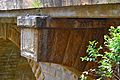
Knapsack Viaduct, detail
-
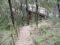
Stairway descent to viaduct from Siding Lookout
-
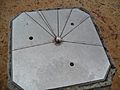
Marker plate on trig. point, indicating distances.
-
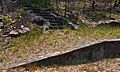
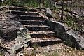
Remains of Lucasville Station and steps
-
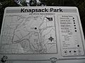
Knapsack Park guide
-
Knapsack_Viaduct-3.jpg)


Lucasville_platform_and_steps.jpg)

Lucasville_platform_steps.JPG)
