
Las Tablas, Los Santos facts for kids
Quick facts for kids
Las Tablas
|
|
|---|---|
|
City
|
|
| Santa Librada de Las Tablas | |
 |
|

Las Tablas
Location in Panama
|
|
| Country | |
| Province | Los Santos |
| District | Las Tablas |
| Founded | 1671 |
| Area | |
| • Land | 7.5 km2 (2.9 sq mi) |
| Elevation | 42 m (138 ft) |
| Population
(2010)
|
|
| • Total | 9,255 |
| • Density | 1,197.6/km2 (3,102/sq mi) |
| Population density calculated based on land area. | |
| Time zone | UTC−5 (EST) |
| Climate | Aw |
Las Tablas is a lively city in Panama. It is the capital of the Los Santos province. In 2010, about 9,255 people lived there. The city is located on the Azuero Peninsula, not far from the Gulf of Panama.
Las Tablas is famous for its rich folk art, music, and delicious gastronomy. It is also known for its unique architecture and deep culture. Many people consider it a national center for Panamanian traditions. Belisario Porras, a former Panamanian president, was from Las Tablas. He was the only president to serve three terms.
Contents
The Famous Carnival
One of the most exciting events in Las Tablas is its yearly Carnival. During this time, the city divides into two friendly rival groups. These groups are called "Calle Arriba" (which means "Uptown" or "Street Above") and "Calle Abajo" (meaning "Downtown" or "Street Below"). Each group is centered around a street with the same name.
Carnival Rivalry
Each "Calle" (street) group works hard to put on the best show. They each choose a carnival queen. Then, they organize amazing parades, fireworks displays, and live music. They also set up decorated plazas and food stands. Both sides hold presentations, concerts, and fun contests. Everyone tries to make their celebration better than the other group's! It's a fun and colorful competition that brings the whole city to life.
Where Did the Name Come From?

The name "Las Tablas" means "The Boards" in Spanish. There's a cool story about how the city got its name. Long ago, a Spanish ship ran aground near where the city is now. This happened when the ship was trying to escape Henry Morgan and his pirates from Panama City.
A Shipwreck Story
According to the story, the people used wooden planks from this shipwreck. They used these boards to build the very first houses in the town. That's how the city got its unique name, "The Boards," or Las Tablas. It's a reminder of its early beginnings.
Images for kids
-
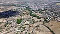
An aerial view of Las Tablas.
See also
- In Spanish: Las Tablas (Los Santos) para niños
