
Laupen District facts for kids
Quick facts for kids
Laupen District
Amtsbezirk Laupen
|
|
|---|---|
|
District
|
|
 |
|
| Country | |
| Canton | |
| Capital | Laupen |
| Area | |
| • Total | 88 km2 (34 sq mi) |
| Population
(2007)
|
|
| • Total | 14,482 |
| • Density | 164.6/km2 (426.2/sq mi) |
| Time zone | UTC+1 (CET) |
| • Summer (DST) | UTC+2 (CEST) |
| Municipalities | 11 |
The Laupen District was an administrative area in Switzerland. It was one of 26 such districts in the canton of Bern. A canton is like a state or province in other countries. The main town, or capital, of the Laupen District was Laupen.
This district covered an area of 88 square kilometers (about 34 square miles). In 2007, about 14,482 people lived there. The Laupen District was made up of 11 smaller towns or villages, which are called municipalities in Switzerland.
Contents
Where was Laupen District?
The Laupen District was located in the western part of the canton of Bern. It was known for its mix of flat lands and rolling hills. The district was important for local government and managing public services for the people living there.
Special Geography: Enclaves
Two of the municipalities in the Laupen District had a unique geographical feature. Clavaleyres and Münchenwiler were enclaves. This means they were completely surrounded by land belonging to a different canton, the canton of Fribourg. Imagine a small island of one state's land completely inside another state!
Why "was" Laupen District?
The Laupen District no longer exists as a separate administrative area. In 2010, Switzerland changed how its districts were organized. Many districts were combined or reorganized into larger administrative regions. The area that was once the Laupen District is now part of the new Bern-Mittelland administrative district.
Images for kids
-
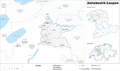
A map showing the Laupen District in 2007.
See also
 In Spanish: Distrito de Laupen para niños
