
Laurel, California facts for kids
Quick facts for kids
Laurel
|
|
|---|---|

Historical marker at Laurel
|
|

Laurel
Location in California
|
|
| Country | United States |
| State | California |
| County | Santa Cruz |
| Time zone | UTC-8 (Pacific (PST)) |
| • Summer (DST) | UTC-7 (PDT) |
Laurel is a fascinating ghost town located in Santa Cruz County, California. It sits high up in the Santa Cruz Mountains, about 900 feet (274 meters) above the sea. A ghost town is a place where people used to live and work, but now it's mostly empty.
Contents
History of Laurel
Laurel became a town because of a special road and a railroad. First, a toll road was built from Los Gatos to Santa Cruz. Stagecoaches used this road to travel through the mountains.
The Mountain Railroad
Later, a narrow gauge railroad was built. This train line helped move lumber and crops grown in the area. Instead of going around steep hills, engineers decided to dig tunnels right through them. Laurel was located in a narrow valley between two of the longest tunnels. Each of these tunnels was over a mile long!
The longest tunnel started near a place called Wrights Station. This tunnel was about 6,200 feet (1.9 kilometers) long. It led to a spot just north of Laurel.
Tunnel Construction Dangers
Building these tunnels was very dangerous work. During the construction of the Summit tunnel, workers hit a strong flow of natural gas. This caused a big explosion, and 32 Chinese workers sadly lost their lives. Even after the main leak was stopped, small amounts of gas continued to escape.
More Tunnels and the Railroad's Completion
From Laurel, the train line went into another long tunnel. This tunnel went southwest and came out near Glenwood. It cut through a ridge about 500 feet (150 meters) below where State Highway 17 is today.
The railroad was finished in 1880. It connected Los Gatos to Felton and then continued south to Santa Cruz. Later, a big company called the Southern Pacific bought the railroad.
The 1906 Earthquake and Its Impact
Laurel and the surrounding area were badly damaged by the April 18, 1906, earthquake. This was because the San Andreas Fault runs right through these mountains. The earthquake caused many cracks in the ground. It also damaged the train tracks, bridges, and tunnels. Many homes and businesses in Laurel were also destroyed.
The End of the Railroad and Laurel
The railroad was repaired after the earthquake and kept running for many years. However, in February 1940, heavy rains caused huge landslides. The Southern Pacific company decided not to fix the damage this time.
Also, State Route 17 was completed west of Laurel in the same year. This new highway made the railroad less important. Because of these reasons, the railroad and several small towns along its path, including Laurel, slowly disappeared.
Today, the village of Laurel no longer exists. Some homes have been built near the old site, and a road called Laurel Drive passes through where the town once stood.
Images for kids
-
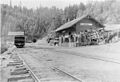
The station building for Laurel with the portal for the Glenwood Tunnel in the background in 1905.
-
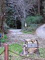
Laurel/Glenwood tunnel portal as it appears today.
_in_background.jpg)

