Laurel, Iowa facts for kids
Quick facts for kids
Laurel, Iowa
|
|
|---|---|
|
City
|
|

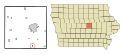
Location of Laurel, Iowa
|
|
| Country | |
| State | |
| County | Marshall |
| Area | |
| • Total | 0.25 sq mi (0.64 km2) |
| • Land | 0.25 sq mi (0.64 km2) |
| • Water | 0.00 sq mi (0.00 km2) |
| Elevation | 1,043 ft (318 m) |
| Population
(2020)
|
|
| • Total | 220 |
| • Density | 894.31/sq mi (344.66/km2) |
| Time zone | UTC-6 (Central (CST)) |
| • Summer (DST) | UTC-5 (CDT) |
| ZIP code |
50141
|
| Area code(s) | 641 |
| FIPS code | 19-43680 |
| GNIS feature ID | 0458239 |
Laurel is a small city located in Marshall County, Iowa, in the United States. In 2020, about 220 people lived there. It's a quiet place with a friendly community.
Contents
History of Laurel
Laurel was first planned out in 1880 by a person named Conrad Weissenburger. This means he drew up the maps for the town. Later, in 1902, Laurel officially became a city. A settler named Rufus Archerd gave the city its name. He named it after another town called Laurel, Ohio.
Where is Laurel?
Laurel is located in central Iowa. Its exact coordinates are 41.883720 degrees North and 92.922906 degrees West. The city covers a total area of about 0.64 square kilometers (0.25 square miles). All of this area is land, with no water.
Education in Laurel
Students in Laurel attend schools that are part of the East Marshall Community School District. This school district was created on July 1, 1992. It was formed when two older school districts, LDF and SEMCO, joined together.
Notable People from Laurel
- Esther Dendel (1910–2002), a non-fiction writer. She wrote books that were based on facts and real events.
- Lt. Colonel Phyllis L. Propp Fowle, the first woman to become an officer in the Judge Advocate General's Corps. This is a special group of lawyers who work for the military.
Population Changes in Laurel
| Historical populations | ||
|---|---|---|
| Year | Pop. | ±% |
| 1910 | 179 | — |
| 1920 | 195 | +8.9% |
| 1930 | 232 | +19.0% |
| 1940 | 232 | +0.0% |
| 1950 | 257 | +10.8% |
| 1960 | 223 | −13.2% |
| 1970 | 245 | +9.9% |
| 1980 | 278 | +13.5% |
| 1990 | 271 | −2.5% |
| 2000 | 266 | −1.8% |
| 2010 | 239 | −10.2% |
| 2020 | 220 | −7.9% |
| Source: and Iowa Data Center Source: |
||
Laurel's Population in 2020
In 2020, the United States census showed that 220 people lived in Laurel. There were 102 households and 70 families. The city had about 344 people per square kilometer (892 people per square mile). Most of the people living in Laurel (96.4%) were White. A small number of people were Asian or from two or more races. About 0.5% of the population was Hispanic or Latino.
The average age of people in Laurel was 50.3 years old. About 21.8% of the residents were under 20 years old. Also, 24.1% of the people were 65 years old or older. Slightly more than half of the residents (54.1%) were male, and 45.9% were female.
Laurel's Population in 2010
Back in 2010, the census counted 239 people living in Laurel. There were 109 households. The population density was about 369 people per square kilometer (956 people per square mile). Most residents (98.7%) were White. A small percentage were African American, Asian, or from two or more races. About 2.1% of the population was Hispanic or Latino.
The average age in 2010 was 43.8 years. About 25.5% of the people were under 18 years old. Also, 18% of the residents were 65 years old or older. The number of males and females was almost equal, with 49.8% male and 50.2% female.
See also
 In Spanish: Laurel (Iowa) para niños
 | Tommie Smith |
 | Simone Manuel |
 | Shani Davis |
 | Simone Biles |
 | Alice Coachman |

