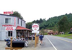
Laurel Springs, North Carolina facts for kids
Quick facts for kids
Laurel Springs, North Carolina
|
|
|---|---|

Entering Laurel Springs
|
|
| Country | United States |
| State | North Carolina |
| County | Alleghany |
| Elevation | 2,749 ft (838 m) |
| Time zone | UTC-5 (Eastern (EST)) |
| • Summer (DST) | UTC-4 (EDT) |
| ZIP code |
28644
|
| Area code(s) | 336 |
| GNIS feature ID | 1021119 |
Laurel Springs is a small, quiet place in Alleghany County, North Carolina, in the United States. It's called an "unincorporated community" because it doesn't have its own local government like a city or town. Instead, it's part of the larger county.
Discover Laurel Springs, North Carolina
Laurel Springs is a charming community located in the beautiful mountains of North Carolina. It's a great spot to visit if you love nature and history.
Where is Laurel Springs Located?
This community sits right where two main roads meet: North Carolina Highway 18 and North Carolina Highway 88. It's also very close to the Ashe County line. If you're coming from Sparta, Laurel Springs is about 10 miles (16 km) southwest.
One of the most famous roads in the area, the Blue Ridge Parkway, goes right through the middle of Laurel Springs. This parkway is known for its amazing scenic views. Laurel Springs also has its own post office with the ZIP code 28644.
A Special Historic Home
Laurel Springs is home to a very important building called the Robert L. Doughton House. This house was added to the National Register of Historic Places in 1979. This means it's recognized as a place with special historical importance.
 | Precious Adams |
 | Lauren Anderson |
 | Janet Collins |


