Lazear, Colorado facts for kids
Quick facts for kids
Lazear, Colorado
|
|
|---|---|

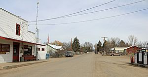
Looking north on 3100 Road in Lazear.
|
|
| Country | |
| State | |
| County | Delta County |
| Government | |
| • Type | unincorporated town |
| Area | |
| • Total | 1.602 sq mi (4.150 km2) |
| • Land | 1.602 sq mi (4.150 km2) |
| • Water | 0 sq mi (0.000 km2) |
| Elevation | 5,440 ft (1,660 m) |
| Population
(2020)
|
|
| • Total | 168 |
| • Density | 104.8/sq mi (40.48/km2) |
| Time zone | UTC-7 (MST) |
| • Summer (DST) | UTC-6 (MDT) |
| ZIP Code |
81420
|
| Area code(s) | 970 |
| GNIS feature | 2804451 |
Lazear is a small community located in Delta County, Colorado, United States. It's known as an unincorporated town, which means it doesn't have its own local government like a big city. Instead, it's managed by the county. Lazear also has its own post office with the ZIP Code 81420. In 2020, about 168 people lived there.
A Look at Lazear's Past
The Lazear Post Office first opened its doors in 1912. This means people have been sending and receiving mail here for over a hundred years! The community gets its name from J. B. Lazear. He was the person who originally owned the land where the town grew.
Where is Lazear?
Lazear is a census-designated place (CDP). This is a special area defined by the United States Census Bureau for counting people. The Lazear CDP covers an area of about 4.15 square kilometers. That's roughly 1.6 square miles. All of this area is land, meaning there are no large lakes or rivers within its boundaries.
Who Lives in Lazear?
Every ten years, the United States Census Bureau counts everyone living in the country. This helps us understand how communities are growing and changing. The last count was in 2020. At that time, 168 people were living in the Lazear CDP.
| Lazear CDP, Colorado | ||
|---|---|---|
| Year | Pop. | ±% |
| 2020 | 168 | — |
| Source: United States Census Bureau | ||
 | Sharif Bey |
 | Hale Woodruff |
 | Richmond Barthé |
 | Purvis Young |


