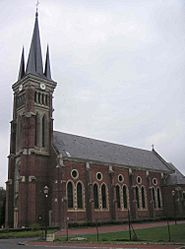
Le Hérie-la-Viéville facts for kids
Quick facts for kids
Le Hérie-la-Viéville
|
|
|---|---|
 |
|
| Country | France |
| Region | Hauts-de-France |
| Department | Aisne |
| Arrondissement | Vervins |
| Canton | Sains-Richaumont |
| Intercommunality | Thiérache du Centre |
| Area
1
|
9.27 km2 (3.58 sq mi) |
| Population
(2008)
|
232 |
| • Density | 25.03/km2 (64.82/sq mi) |
| Time zone | UTC+01:00 (CET) |
| • Summer (DST) | UTC+02:00 (CEST) |
| INSEE/Postal code |
02379 /02120
|
| Elevation | 82–152 m (269–499 ft) (avg. 107 m or 351 ft) |
| 1 French Land Register data, which excludes lakes, ponds, glaciers > 1 km2 (0.386 sq mi or 247 acres) and river estuaries. | |
Le Hérie-la-Viéville is a small commune in northern France. It is like a small town or village. You can find it in the Aisne department. This department is part of the region called Picardie.
About Le Hérie-la-Viéville
Le Hérie-la-Viéville is a quiet place. It is home to about 232 people. This number was counted in 2008. The commune covers an area of 9.27 square kilometers. That is about 3.58 square miles.
Location and Geography
The commune is located in the northern part of France. It is in the Aisne department. The land here is not completely flat. The lowest point is 82 meters (269 feet) above sea level. The highest point reaches 152 meters (499 feet). The average elevation is 107 meters (351 feet).
Local Government
Like all communes in France, Le Hérie-la-Viéville has a mayor. The mayor helps run the local area. Eric Buysse was the mayor from 2008 to 2014. The commune is also part of a larger group. This group is called Thiérache du Centre. It helps different towns work together.
See also
 In Spanish: Le Hérie-la-Viéville para niños
 | Georgia Louise Harris Brown |
 | Julian Abele |
 | Norma Merrick Sklarek |
 | William Sidney Pittman |


