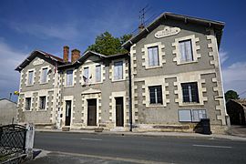
Le Temple, Gironde facts for kids
Quick facts for kids
Le Temple
|
||
|---|---|---|
 |
||
|
||
| Country | France | |
| Region | Nouvelle-Aquitaine | |
| Department | Gironde | |
| Arrondissement | Lesparre-Médoc | |
| Canton | Le Sud-Médoc | |
| Intercommunality | Médulienne | |
| Area
1
|
71.83 km2 (27.73 sq mi) | |
| Population
(Jan. 2019)
|
633 | |
| • Density | 8.812/km2 (22.824/sq mi) | |
| Time zone | UTC+01:00 (CET) | |
| • Summer (DST) | UTC+02:00 (CEST) | |
| INSEE/Postal code |
33528 /33680
|
|
| Elevation | 29–47 m (95–154 ft) (avg. 30 m or 98 ft) |
|
| 1 French Land Register data, which excludes lakes, ponds, glaciers > 1 km2 (0.386 sq mi or 247 acres) and river estuaries. | ||
Le Temple, Gironde is a small commune located in the southwest of France. A commune is like a local town or village area with its own government. It is part of the Gironde department and the region Aquitaine.
Contents
Discover Le Temple
Le Temple is a charming place in the Gironde department. This area is known for its beautiful landscapes. It is located in the Lesparre-Médoc arrondissement.
Where is Le Temple Located?
Le Temple is found in the southwest part of France. It is in the Gironde department. This department is famous for its vineyards and forests. The region of Aquitaine is known for its rich history and natural beauty.
What is a Commune?
In France, a commune is the smallest unit of local government. It is similar to a city or town. Each commune has a mayor and a local council. They manage local services for the people living there.
Local Government and Leadership
The mayor of Le Temple is Jean-Luc Pallin. He was elected to lead the commune from 2008 to 2014. The mayor helps make decisions for the community. He works with the local council to serve the residents.
Quick Facts About Le Temple
- Population: As of January 2019, about 633 people live in Le Temple.
- Area: The commune covers an area of 71.83 square kilometers.
- Elevation: The land is mostly flat, with elevations ranging from 29 to 47 meters above sea level. The average elevation is 30 meters.
- Postal Code: The postal code for Le Temple is 33680.
See also
 In Spanish: Le Temple (Gironda) para niños


