Leahill Turret, Hadrian's Wall facts for kids
Quick facts for kids Leahill Turret, Hadrian's Wall |
|
|---|---|
| Banks, Cumbria, England | |

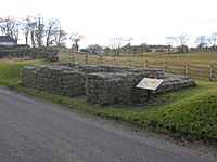
Leahill Turret looking north-west
|
|
| Coordinates | 54°58′44″N 2°39′06″W / 54.978918°N 2.651793°W |
| Grid reference | NY 5838 6512 |
| Height | 1 metre |
| Site information | |
| Owner | English Heritage |
| Open to the public |
Yes |
| Condition | Excavated and consolidated |
| Site history | |
| Built | Circa 122 AD |
| In use | 2nd and 4th century |
| Materials | Stone |
Leahill Turret is a cool lookout tower found along Hadrian's Wall in Cumbria, England. It's like one of many small forts built between bigger forts called milecastles. This turret is known as "51b" and is located near the village of Banks. It helped soldiers keep watch over the Roman frontier.
Contents
Where is Leahill Turret?
Leahill Turret sits on a gentle hill called Allieshaw Rigg. It's positioned between other important Roman sites. To its west, about 540 yards away, is Milecastle 52. To its east, also about 540 yards away, is Turret 51A, called Piper Syke. Further east is Milecastle 51.
The Story of Leahill Turret
When Was It Built?
Leahill Turret 51b was built around 122 AD. This was soon after the Roman Emperor Hadrian ordered the construction of his famous wall. The turret was part of this huge defensive line.
How Was It Used?
Soldiers used these lookout towers only for short periods. They would patrol the wall and use the turrets as temporary bases. Later, under Emperor Septimius Severus, parts of Hadrian's Wall were taken down. Leahill Turret was then used again for a short time in the late 300s AD.
Discovery and Excavation
For many years, Leahill Turret was hidden under a road. In 1927, people started digging and found it! They also discovered where the original "turf wall" was. This turf wall was an earlier version of Hadrian's Wall made of earth and grass. The new road was then built behind the turret and the wall.
In 1958, archaeologists fully dug out Leahill Turret. This helped them learn more about it before making sure it was safe and preserved.
What Did It Look Like?
This Roman turret was a separate building right next to Hadrian's Wall. Inside, it measured about 13 feet 8 inches from north to south and 14 feet 6 inches from east to west. Over time, many of its stones were taken away. It only stands about one metre (or 9 stone layers) high today.
Archaeologists found a platform inside the north wall. In the 300s AD, a small shelter was built against the south wall. They also found several layers of old materials from when people lived there. Below these layers, there was a stone floor.
Nearby Features
A small house once stood close to the turret, across the road. Stones from the turret were also used to build fences and a nearby farm called Leahill Farm.
The big ditch in front of Hadrian's Wall is still easy to see in this area. This ditch was another part of the Roman defenses. The Vallum, a large earthwork behind the wall, is also visible.
Interesting Facts About the Area
Modern Trails
The road that passes Leahill Turret is now part of two popular trails. These are the Hadrian's Wall Path National Trail and Hadrian's Cycleway. People can walk or bike along these routes.
Roman Discoveries
People using metal detectors have found many Roman coins near Leahill Turret. During the 1958 digs, a human skeleton was also found.
Illuminating Hadrian's Wall Event
On March 13, 2010, something amazing happened! All 84 miles of Hadrian's Wall were lit up with lights. About 500 gas beacons, flares, and torches were placed every 250 metres. Over 1,000 volunteers helped make this happen.
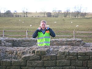
Leahill Turret was part of this special event. Two volunteers stood guard there. This event celebrated 1600 years since the Romans left Britain in 410 AD. A helicopter even filmed the 500 lights from above at sunset.
What Were Roman Turrets Like?
Roman turrets were built in a similar way. They usually had two floors. The ground floor was used for cooking. Soldiers likely used a movable ladder to get to the upper floor. The top floor probably had beds for two soldiers. The other two soldiers would be out on patrol.
There's a story that soldiers used pipes to talk between turrets. Fires inside provided some light. Instead of a chimney, they had an unglazed window for smoke to escape. A stone tank for water would have been built into the floor.
Images for kids
 | Bessie Coleman |
 | Spann Watson |
 | Jill E. Brown |
 | Sherman W. White |


