Lees River facts for kids
Quick facts for kids Lees River |
|
|---|---|

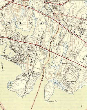
Lees River and environs
|
|
| Country | United States |
| State | Massachusetts |
| County | Bristol County |
| Physical characteristics | |
| Main source | 41°44′37″N 71°11′21″W / 41.7436°N 71.1891°W |
| River mouth | Mount Hope Bay 41°43′11″N 71°11′45″W / 41.7197°N 71.1957°W |
| Length | 2.9 mi (4.7 km) |
The Lees River (sometimes called Lee's River or just Lee River on official maps) is a short river in Massachusetts, USA. It's about 2.9 miles (4.7 kilometers) long. This river is special because it's a tidal river. This means its water level changes with the ocean tides, just like the beach!
The Lees River forms part of the border between two towns: Swansea and Somerset, Massachusetts. It flows south until it reaches Mount Hope Bay, which is part of the larger Narragansett Bay.
History of the Lees River
The Lees River has been important to the local area for a long time. The very first shipyard in the area was built on this river. It was set up by a person named Samuel Lee sometime between 1707 and 1712. Shipyards are places where boats are built and repaired.
The River's Health
Today, the Lees River is considered a very healthy and important waterway. It has been given a special rating: Class A, "outstanding resource" water. This means the river's water quality is excellent. It's clean enough to be used for things like swimming and fishing, and it's a great home for many plants and animals. This rating helps protect the river for everyone to enjoy.
 | Kyle Baker |
 | Joseph Yoakum |
 | Laura Wheeler Waring |
 | Henry Ossawa Tanner |

