Swansea, Massachusetts facts for kids
Quick facts for kids
Swansea, Massachusetts
|
|||
|---|---|---|---|
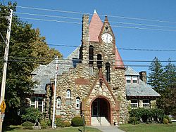
Swansea Town Hall
|
|||
|
|||
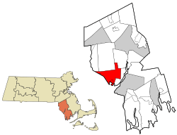
Location in Bristol County in Massachusetts
|
|||
| Country | United States | ||
| State | Massachusetts | ||
| County | Bristol | ||
| Settled | 1662 | ||
| Incorporated | March 5, 1667 | ||
| Government | |||
| • Type | Open town meeting | ||
| Area | |||
| • Total | 25.5 sq mi (66.1 km2) | ||
| • Land | 23.1 sq mi (59.7 km2) | ||
| • Water | 2.5 sq mi (6.4 km2) | ||
| Elevation | 22 ft (7 m) | ||
| Population
(2020)
|
|||
| • Total | 17,144 | ||
| • Density | 672.3/sq mi (259.36/km2) | ||
| Time zone | UTC-5 (Eastern) | ||
| • Summer (DST) | UTC-4 (Eastern) | ||
| ZIP code |
02777
|
||
| Area code(s) | 508 / 774 | ||
| FIPS code | 25-68750 | ||
| GNIS feature ID | 0619439 | ||
| Website | www.swanseama.gov | ||
Swansea is a town in southeastern Massachusetts, United States. It's located in Bristol County, right where the Taunton River meets the sea. Swansea is about 47 miles (76 km) south of Boston and 12 miles (19 km) southeast of Providence, Rhode Island.
In 2020, about 17,144 people lived here. Swansea includes smaller areas called villages, like Hortonville, Barneyville, and Ocean Grove. The town is part of the "South Coast" region of Massachusetts. This area includes towns and cities around Buzzards Bay and Mount Hope Bay.
Contents
History of Swansea
Early Settlement and Naming
Swansea was named after the city of Swansea in Wales. Some of the first people to settle here came from that Welsh city. John Miles, who started the first Baptist Church in Wales, moved to Swansea around 1662. William Brenton bought the land from Native Americans. Some parts of Swansea were originally part of Rehoboth, Massachusetts.
Becoming an Independent Town
In 1667, the first Baptist church in Massachusetts moved to Swansea. They had faced problems in Rehoboth because of their religious beliefs. After they moved, Swansea officially became its own town.
At first, the town had a special system. A committee decided if residents were rank 1, 2, or 3. Rank 1 people got 3 acres of land, rank 2 got 2 acres, and rank 3 got 1 acre. The committee could change a person's rank. But this system ended in 1681 when the town voted to stop it.
King Philip's War Impact
On June 20, 1675, Swansea faced the first attack of King Philip's War. All 70 settlers had to stay inside their fort. The attack happened near the Miles Garrison. By June 25, the whole town was burned down. A few colonists escaped to Taunton. After the war ended in 1676, the town was quickly rebuilt. The Miles Garrison building was taken down in the 1970s. Today, a marker stands there to remember the event.
Growth and Modern Connections
After the war, many small businesses started in Swansea. These included places for making iron and fishing. Many of these businesses later closed, but farming remained important. In 1717, what is now Barrington, Rhode Island separated from Swansea. This happened because of different religious views.
In the late 1890s, trolleys connected Swansea to nearby cities like Providence, Fall River, and Taunton. This helped Swansea become a residential town, meaning many people live there and travel to work elsewhere. Today, Swansea is known for its many stores and shopping areas.
A Story of Inclusion
In 1985, Swansea gained national attention for an important decision. A young boy named Mark Hoyle, who had a health condition, was allowed to attend public schools. This was one of the first times in the U.S. that a student with this condition was allowed in public schools. This case, along with others, helped many children attend schools across the country. Mark Hoyle passed away a year later, and an elementary school in Swansea was named in his honor.
Geography of Swansea
Swansea covers about 25.5 square miles (66 km2) of land and water. About 23.1 square miles (60 km2) is land, and 2.5 square miles (6.5 km2) is water. The town is next to Dighton to the northeast and Somerset to the east. To the south is Mount Hope Bay. On the west, Swansea borders Warren, Rhode Island, Barrington, Rhode Island, Seekonk, and Rehoboth.
Rivers and Waterways
Several rivers flow through Swansea. The Lees River forms part of the border with Somerset. The Cole, Kickemuit, and Palmer rivers also pass through the town. All of Swansea is part of the larger Narragansett Bay watershed area.
Town Areas and Shopping
Swansea has several neighborhoods, including Barneyville, North Swansea, Swansea Village, and Ocean Grove. Most of the town's stores and businesses are found along major roads. These include U.S. Route 6 and Massachusetts Route 118. The area around the former Swansea Mall is a busy retail spot. You'll also find many smaller businesses along Route 103. Outside of these busy areas, much of Swansea is still rural, with open spaces.
Population and People
| Historical population | ||
|---|---|---|
| Year | Pop. | ±% |
| 1850 | 1,554 | — |
| 1860 | 1,430 | −8.0% |
| 1870 | 1,294 | −9.5% |
| 1880 | 1,355 | +4.7% |
| 1890 | 1,456 | +7.5% |
| 1900 | 1,645 | +13.0% |
| 1910 | 1,978 | +20.2% |
| 1920 | 2,334 | +18.0% |
| 1930 | 3,941 | +68.9% |
| 1940 | 4,684 | +18.9% |
| 1950 | 6,121 | +30.7% |
| 1960 | 9,916 | +62.0% |
| 1970 | 12,640 | +27.5% |
| 1980 | 15,461 | +22.3% |
| 1990 | 15,411 | −0.3% |
| 2000 | 15,901 | +3.2% |
| 2010 | 15,865 | −0.2% |
| 2020 | 17,144 | +8.1% |
| 2023 | 17,375 | +1.3% |
Source: United States Census records and Population Estimates Program data. |
||
In 2000, there were about 15,901 people living in Swansea. There were 5,888 households, with many being families. The average household had about 2.67 people.
About 22.2% of the population was under 18 years old. About 15.7% were 65 years or older. The average age in Swansea was 40 years. For every 100 females, there were about 96.9 males.
The median income for a household in Swansea was about $52,524. This means half of the households earned more than this, and half earned less. About 4.9% of the population lived below the poverty line.
Education in Swansea
Local Schools
The Swansea Public Schools serve students in the town. There are four elementary schools:
- Joseph G. Luther Elementary School
- Gardner Elementary School
- Elizabeth S. Brown Elementary School
- Mark Hoyle Elementary School (named after the student mentioned in the history section)
After elementary school, students attend Joseph Case Junior High School. Then they go to Joseph Case High School. The high school's colors are maroon and gold, and its mascot is the Cardinal.
Other School Options
High school students in Swansea also have other choices. They can attend Diman Regional Vocational Technical High School in Fall River. Or they can go to Bristol County Agricultural High School in Dighton. There are also two Christian schools in Swansea. Nearby towns like Warren and Fall River have Catholic schools.
Higher Education
For adults, Eastern Nazarene College offers special classes in Swansea.
Transportation
Swansea is crossed by several important roads. These include Interstate 195, U.S. Route 6, and state routes 103, 118, and 136. Interstate 195 has two exits that serve Swansea.
Public Transport
Swansea is the starting point for the Southeastern Regional Transit Authority (SRTA) bus line. You can find more bus services in Fall River. The closest train service is in Providence, Rhode Island. For air travel, the nearest airport is T. F. Green Airport in Rhode Island. For international flights, you can go to Logan International Airport in Boston.
Notable People
- Antone S. Aguiar Jr., politician
- Benjamin Brown, politician
- Benjamin Carpenter, military officer
- Oliver Chace, businessman
- Warren A. Cole, lawyer
- Mark Anthony DeWolf, merchant
- Bob Evans, wrestler
- Joshua K. Ingalls, inventor
- David Leite, writer
- John Myles, founder of Swansea
- David J. Place, politician
- Cheryl Wheeler, musician
- Thomas Willett, politician
See also
 In Spanish: Swansea (Massachusetts) para niños
 | William Lucy |
 | Charles Hayes |
 | Cleveland Robinson |


