Leoma, Tennessee facts for kids
Quick facts for kids
Leoma, Tennessee
|
|
|---|---|

Leoma
|
|
| Country | United States |
| State | Tennessee |
| County | Lawrence |
| Area | |
| • Total | 1.90 sq mi (4.91 km2) |
| • Land | 1.90 sq mi (4.91 km2) |
| • Water | 0.00 sq mi (0.00 km2) |
| Elevation | 958 ft (292 m) |
| Population
(2020)
|
|
| • Total | 464 |
| • Density | 244.60/sq mi (94.43/km2) |
| Time zone | Central (CST) |
| • Summer (DST) | CDT |
| ZIP code |
38468
|
| Area code(s) | 931 |
| GNIS feature ID | 1291024 |
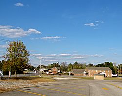
Leoma is a small place in Lawrence County, Tennessee, United States. It is known as an unincorporated community. This means it's not an official city or town with its own local government. Instead, it's part of the larger county.
Leoma is also a census-designated place (CDP). This is a special area that the U.S. Census Bureau defines. They do this to collect information about the people living there. You can find Leoma along U.S. Route 43. It is located between the towns of Loretto and Lawrenceburg.
What Can You Find in Leoma?
Leoma is home to a few interesting spots. One of them is the G.T. Wilburn Grist Mill. A grist mill is a place where grain is ground into flour.
The community also has Leoma Elementary School. This is where local children go to learn. You can also find the Lawrence County Archives here. This is a place that keeps old records and historical documents.
For nature lovers, there is the Hope Botanical Garden. It is a beautiful place to see different plants. Leoma also has its own post office. Its special code is 38468.
How Many People Live in Leoma?
In 2020, a count was done to see how many people live in Leoma. This count is called a census. The population of Leoma was 464 people.
| Historical population | |||
|---|---|---|---|
| Census | Pop. | %± | |
| 2020 | 464 | — | |
| U.S. Decennial Census | |||
 | Lonnie Johnson |
 | Granville Woods |
 | Lewis Howard Latimer |
 | James West |


