Leonding facts for kids
Quick facts for kids
Leonding
|
|||
|---|---|---|---|
|
Municipality
|
|||

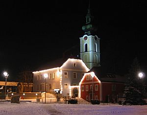
Saint Michael's church, Leonding
|
|||
|
|||
| Country | Austria | ||
| State | Upper Austria | ||
| District | Linz-Land | ||
| Area | |||
| • Total | 24.04 km2 (9.28 sq mi) | ||
| Elevation | 289 m (948 ft) | ||
| Population
(2018-01-01)
|
|||
| • Total | 28,698 | ||
| • Density | 1,193.76/km2 (3,091.8/sq mi) | ||
| Time zone | UTC+1 (CET) | ||
| • Summer (DST) | UTC+2 (CEST) | ||
| Postal code |
4060
|
||
| Area code | 0732 | ||
| Vehicle registration | LL | ||
| Website | www.leonding.at | ||
Leonding (German pronunciation: [ˈleːɔ̯nd̥iŋ]) is a town in Upper Austria, a state in Austria. It is located southwest of the city of Linz. Leonding is bordered by Puchenau and the Danube river to the north. To the west, it borders Wilhering and Pasching, and to the south, Traun. Linz is to its east.
Leonding is the largest town in the Linz-Land district. It is also the fourth most populated town in all of Upper Austria. The town is very close to Linz and offers beautiful views of the Alps. Many people choose to live here because of its location and views.
Leonding is well-connected by transport. It has access to the West railway, the Westautobahn (a major highway), and the B1 Wiener Straße road. Linz Airport is also nearby. These connections make it a good place for businesses. Companies like Rosenbauer, Ebner Industrieofenbau, Poloplast, and Neuson are located here. Big shopping centers like UNO Shopping Center and Plus City Shopping Center also provide many jobs.
From 1898 to 1905, a person named Adolf Hitler lived in Leonding. He went to primary school there. Later, he attended a grammar school in nearby Linz. The graves of his parents, Alois and Klara, were in Leonding. His brother Edmund, who died from measles, was also buried there. In 1903, Hitler's father passed away in a guesthouse in Leonding. The family grave was later dissolved in 2012.
Leonding is divided into 22 smaller areas called localities. These include Aichberg, Alharting, Berg, Bergham, Buchberg, Doppl, Enzenwinkl, Felling, Friesenegg, Gaumberg, Haag, Hart, Holzheim, Imberg, Jetzing, Leonding, Reith, Rufling, St. Isidor, Staudach, Untergaumberg, and Zaubertal.
Contents
Population Growth in Leonding
| Historical population | ||
|---|---|---|
| Year | Pop. | ±% |
| 1869 | 2,250 | — |
| 1880 | 2,378 | +5.7% |
| 1890 | 3,016 | +26.8% |
| 1900 | 3,829 | +27.0% |
| 1910 | 4,365 | +14.0% |
| 1923 | 4,762 | +9.1% |
| 1934 | 5,235 | +9.9% |
| 1939 | 5,771 | +10.2% |
| 1951 | 6,832 | +18.4% |
| 1961 | 11,211 | +64.1% |
| 1971 | 14,968 | +33.5% |
| 1981 | 19,389 | +29.5% |
| 1991 | 21,209 | +9.4% |
| 2001 | 22,203 | +4.7% |
| 2011 | 25,295 | +13.9% |
| 2018 | 28,698 | +13.5% |
The town of Leonding has grown a lot since the year 2000. In 2001, its population was 22,203 people. By 2018, it had jumped to 28,698 people.
This fast growth happened for a few reasons. One reason is that homes in Leonding were more affordable than in nearby Linz. Many middle-class families found Leonding an attractive place to live.
Local Government in Leonding
Leonding has a local council that helps run the town. The council members are chosen through elections.
2015 Election Results
The elections in 2015 showed how different political parties were supported.
| Party | Vote share | change | Seats in the Gemeinderat | change | Seats in the Stadtrat |
|---|---|---|---|---|---|
| SPÖ | 33,84 % | - 9,23 % | 13 | -4 | 4 |
| FPÖ | 23,39 % | + 9,92 % | 9 | +4 | 2 |
| ÖVP | 22,27 % | - 6,80 % | 8 | -3 | 2 |
| The Greens - The Green Alternative | 13,64 % | + 2,05 % | 5 | +1 | 1 |
| NEOS | 5,97 % | + 5,97 % | 2 | +2 | 0 |
In total, there are 37 seats on the local council.
Mayors of Leonding
The mayor is the head of the town's government. Here are the mayors of Leonding since 1945.
| Mayors since 1945 | |||
|---|---|---|---|
| Name | Party | Term of office | |
| Josef Lehner | SPÖ | 1946-1961 | |
| Franz Klafböck | SPÖ | 1961-1968 | |
| Leopold Finster | SPÖ | 1968-1982 | |
| Leopold Kronsteiner | SPÖ | 1982-1997 | |
| Herbert Sperl | SPÖ | 1997-2008 | |
| Walter Brunner | SPÖ | since 2008 | |
See also
 In Spanish: Leonding para niños
 | Frances Mary Albrier |
 | Whitney Young |
 | Muhammad Ali |


