Linden, Michigan facts for kids
Quick facts for kids
Linden, Michigan
|
|
|---|---|
| City of Linden | |

|
|

Location within Genesee County
|
|
| Country | United States |
| State | Michigan |
| County | Genesee |
| Settled | 1835 |
| Platted | 1840 |
| Incorporated | 1871 (village) 1988 (city) |
| Government | |
| • Type | Council–manager |
| Area | |
| • Total | 2.42 sq mi (6.27 km2) |
| • Land | 2.35 sq mi (6.10 km2) |
| • Water | 0.07 sq mi (0.17 km2) 2.88% |
| Elevation | 873 ft (266 m) |
| Population
(2020)
|
|
| • Total | 4,142 |
| • Density | 1,758.81/sq mi (679.10/km2) |
| Time zone | UTC-5 (EST) |
| • Summer (DST) | UTC-4 (EDT) |
| ZIP code(s) |
48451
|
| Area code(s) | 810 |
| FIPS code | 26-47820 |
| GNIS feature ID | 0630496 |
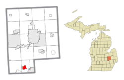
Linden is a city located in the southern part of Genesee County, Michigan, in the United States. In 2020, about 4,142 people lived there. It's part of the larger Flint area.
History of Linden
Linden was first settled in late 1835 by two brothers, Richard and Perry Lamb. Perry Lamb helped travelers by providing them with places to stay. The area was officially mapped out as a village in 1840 by Consider Warner and Eben Harris. They also built a hotel called Springer's Hotel that same year.
The Linden post office opened on September 23, 1851. In 1857, another small area called North Linden was mapped out near the railroad. Linden officially became a village in 1871.
In 1974, the community started its "Summer Happening" festival. Later, in 1988, Linden changed its official status from a village to a city.
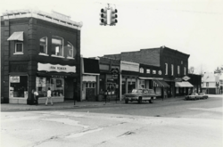
In 2007, a big fire destroyed the historic Union Block building, which had businesses and apartments. The building was taken down to make way for new developments. In 2014, an underground gasoline leak affected this area and other downtown properties.
Linden has also seen changes with its festivals. The "Summer Happening" festival was not held in 2011. Instead, a new festival called "Linden Mills Days" started that year.
Geography of Linden
Linden covers an area of about 2.43 square miles (6.27 square kilometers). Most of this area is land, with a small part covered by water. Linden is a low-lying area, typical of southern Michigan. It has marshes, swamps, and lakes that were once dredged. It is surrounded by Fenton Township.
Population and People
| Historical population | |||
|---|---|---|---|
| Census | Pop. | %± | |
| 1860 | 271 | — | |
| 1870 | 565 | 108.5% | |
| 1880 | 676 | 19.6% | |
| 1890 | 552 | −18.3% | |
| 1900 | 543 | −1.6% | |
| 1910 | 550 | 1.3% | |
| 1920 | 579 | 5.3% | |
| 1930 | 717 | 23.8% | |
| 1940 | 782 | 9.1% | |
| 1950 | 933 | 19.3% | |
| 1960 | 1,146 | 22.8% | |
| 1970 | 1,546 | 34.9% | |
| 1980 | 2,174 | 40.6% | |
| 1990 | 2,415 | 11.1% | |
| 2000 | 2,861 | 18.5% | |
| 2010 | 3,991 | 39.5% | |
| 2020 | 4,142 | 3.8% | |
| U.S. Decennial Census | |||
In 2010, there were 3,991 people living in Linden. These people lived in 1,552 households, with 1,067 of them being families. The city had about 1,691 people per square mile.
Most of the people in Linden were White (93.8%). There were also smaller groups of African American (3.5%), Native American (0.5%), and Asian (0.4%) residents. About 2.0% of the population identified as Hispanic or Latino.
The average age of people in Linden was about 39.5 years old. Around 25.6% of residents were under 18 years old. About 19.9% were 65 years or older. The city had slightly more females (53.0%) than males (47.0%).
See also
 In Spanish: Linden (Míchigan) para niños


