Lindon, Colorado facts for kids
Quick facts for kids
Lindon, Colorado
|
|
|---|---|

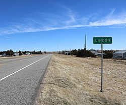
Looking east on U.S. Route 36 in Lindon
|
|
| Country | |
| State | |
| County | Washington |
| Elevation | 4,918 ft (1,499 m) |
| Time zone | UTC-7 (MST) |
| • Summer (DST) | UTC-6 (MDT) |
| ZIP code |
80740
|
| GNIS feature ID | 0204815 |
Lindon is a small place in Washington County, Colorado, United States. It's known as an unincorporated community. This means it doesn't have its own local government like a city or town. Instead, it's managed by the county. Lindon also has its own U.S. Post Office with the ZIP Code 80740.
Where is Lindon?
Lindon is located in eastern Colorado. You can find it using its geographic coordinates: 39.736894 degrees North and 103.405552 degrees West. This helps pinpoint its exact spot on a map. Before it was called Lindon, this area had other names like Linden and Harrisburg.
What's the Weather Like?
Lindon has a type of weather called a cold semi-arid climate. This means it's generally dry, but it gets enough rain to avoid being a desert. It also has cold winters.
The weather in Lindon can be quite extreme! The hottest temperature ever recorded there was a scorching 108 degrees Fahrenheit (about 42 degrees Celsius). This happened on two separate days: June 25, 2012, and June 27, 2012. On the other hand, the coldest temperature ever recorded was a freezing -30 degrees Fahrenheit (about -34 degrees Celsius) on December 22, 1989.
Here's a detailed look at the average weather in Lindon:
| Climate data for Lindon, Colorado, 1991–2020 normals, extremes 1988–present | |||||||||||||
|---|---|---|---|---|---|---|---|---|---|---|---|---|---|
| Month | Jan | Feb | Mar | Apr | May | Jun | Jul | Aug | Sep | Oct | Nov | Dec | Year |
| Record high °F (°C) | 76 (24) |
79 (26) |
86 (30) |
90 (32) |
97 (36) |
108 (42) |
105 (41) |
105 (41) |
102 (39) |
92 (33) |
85 (29) |
76 (24) |
108 (42) |
| Mean maximum °F (°C) | 64.0 (17.8) |
67.0 (19.4) |
77.6 (25.3) |
83.1 (28.4) |
89.9 (32.2) |
98.0 (36.7) |
100.5 (38.1) |
98.4 (36.9) |
94.7 (34.8) |
86.6 (30.3) |
75.4 (24.1) |
65.1 (18.4) |
101.5 (38.6) |
| Mean daily maximum °F (°C) | 44.4 (6.9) |
46.5 (8.1) |
56.8 (13.8) |
63.9 (17.7) |
73.3 (22.9) |
85.3 (29.6) |
91.9 (33.3) |
89.5 (31.9) |
81.7 (27.6) |
67.8 (19.9) |
54.5 (12.5) |
44.6 (7.0) |
66.7 (19.3) |
| Daily mean °F (°C) | 28.7 (−1.8) |
30.8 (−0.7) |
40.1 (4.5) |
47.1 (8.4) |
57.0 (13.9) |
68.3 (20.2) |
74.8 (23.8) |
72.6 (22.6) |
64.0 (17.8) |
50.1 (10.1) |
38.0 (3.3) |
29.1 (−1.6) |
50.1 (10.0) |
| Mean daily minimum °F (°C) | 13.0 (−10.6) |
15.0 (−9.4) |
23.4 (−4.8) |
30.4 (−0.9) |
40.6 (4.8) |
51.3 (10.7) |
57.6 (14.2) |
55.6 (13.1) |
46.2 (7.9) |
32.5 (0.3) |
21.6 (−5.8) |
13.6 (−10.2) |
33.4 (0.8) |
| Mean minimum °F (°C) | −7.8 (−22.1) |
−5.6 (−20.9) |
5.7 (−14.6) |
15.9 (−8.9) |
26.3 (−3.2) |
38.3 (3.5) |
48.9 (9.4) |
46.9 (8.3) |
32.4 (0.2) |
14.8 (−9.6) |
2.6 (−16.3) |
−5.5 (−20.8) |
−14.5 (−25.8) |
| Record low °F (°C) | −25 (−32) |
−24 (−31) |
−20 (−29) |
0 (−18) |
11 (−12) |
30 (−1) |
40 (4) |
37 (3) |
25 (−4) |
−7 (−22) |
−15 (−26) |
−30 (−34) |
−30 (−34) |
| Average precipitation inches (mm) | 0.35 (8.9) |
0.33 (8.4) |
0.83 (21) |
1.50 (38) |
2.34 (59) |
2.28 (58) |
2.77 (70) |
2.44 (62) |
1.17 (30) |
0.94 (24) |
0.52 (13) |
0.29 (7.4) |
15.76 (399.7) |
| Average snowfall inches (cm) | 4.1 (10) |
3.9 (9.9) |
4.3 (11) |
2.8 (7.1) |
0.2 (0.51) |
0.0 (0.0) |
0.0 (0.0) |
0.0 (0.0) |
0.5 (1.3) |
2.1 (5.3) |
4.2 (11) |
4.8 (12) |
26.9 (68.11) |
| Average precipitation days (≥ 0.01 in) | 2.7 | 3.2 | 4.6 | 6.5 | 8.6 | 7.8 | 8.7 | 7.2 | 4.1 | 4.1 | 3.7 | 2.9 | 64.1 |
| Average snowy days (≥ 0.1 in) | 2.2 | 2.5 | 2.1 | 1.1 | 0.2 | 0.0 | 0.0 | 0.0 | 0.1 | 1.1 | 2.2 | 2.8 | 14.3 |
| Source 1: NOAA | |||||||||||||
| Source 2: National Weather Service | |||||||||||||
 | Valerie Thomas |
 | Frederick McKinley Jones |
 | George Edward Alcorn Jr. |
 | Thomas Mensah |


