Lindry facts for kids
Quick facts for kids
Lindry
|
||
|---|---|---|

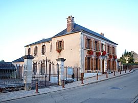
The town hall in Lindry
|
||
|
||
| Country | France | |
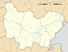
| Region | Bourgogne-Franche-Comté | |
| Department | Yonne | |
| Arrondissement | Auxerre | |
| Canton | Auxerre-1 | |
| Area
1
|
15.23 km2 (5.88 sq mi) | |
| Population
(Jan. 2019)
|
1,393 | |
| • Density | 91.46/km2 (236.89/sq mi) | |
| Time zone | UTC+01:00 (CET) | |
| • Summer (DST) | UTC+02:00 (CEST) | |
| INSEE/Postal code |
89228 /89240
|
|
| Elevation | 140–272 m (459–892 ft) | |
| 1 French Land Register data, which excludes lakes, ponds, glaciers > 1 km2 (0.386 sq mi or 247 acres) and river estuaries. | ||
Lindry is a small and charming commune, which is like a town or village, located in the Yonne department in central France. It is part of the Bourgogne-Franche-Comté region. This area is known for its beautiful countryside and rich history.
About Lindry
Lindry is a quiet place where people live and work. It is officially known as a "commune" in France. This means it is a local administrative area. Each commune has its own local government.
Location and Geography
Lindry is found in the Yonne department. This department is in the middle of France. The commune covers an area of about 15.23 square kilometers. That's roughly 5.88 square miles.
The land in Lindry has different heights. The lowest point is 140 meters above sea level. The highest point reaches 272 meters. This variation in height creates interesting landscapes.
Population
As of January 2019, Lindry had a population of 1,393 people. This makes it a smaller community. The number of people living there helps define its character.
See also
 In Spanish: Lindry para niños
 | Aaron Henry |
 | T. R. M. Howard |
 | Jesse Jackson |


