
Linndale, Ohio facts for kids
Quick facts for kids
Linndale, Ohio
|
|
|---|---|
|
Village
|
|

Village Hall
|
|

Location in Cuyahoga County and the state of Ohio.
|
|
| Country | United States |
| State | Ohio |
| County | Cuyahoga |
| Area | |
| • Total | 0.07 sq mi (0.19 km2) |
| • Land | 0.07 sq mi (0.19 km2) |
| • Water | 0.00 sq mi (0.00 km2) |
| Elevation | 755 ft (230 m) |
| Population
(2020)
|
|
| • Total | 108 |
| • Density | 1,479.45/sq mi (573.54/km2) |
| Time zone | UTC-5 (Eastern (EST)) |
| • Summer (DST) | UTC-4 (EDT) |
| ZIP code |
44135
|
| Area code(s) | 216 |
| FIPS code | 39-43918 |
| GNIS feature ID | 1065002 |
Linndale is a very small village located in Cuyahoga County, Ohio, in the United States. It's unique because it's completely surrounded by other places. The big city of Cleveland and the nearby town of Brooklyn completely enclose it. In 2020, a count of all the people living there, called a census, showed that only 108 people lived in Linndale.
Contents
Where is Linndale Located?
Linndale is found at these map coordinates: 41°26′39″N 81°46′3″W / 41.44417°N 81.76750°W. It's a very tiny place, with a total area of only about 0.19 square kilometers (or 0.07 square miles). All of this area is land.
The village shares its southeast border with Brooklyn. All other sides of Linndale are surrounded by different neighborhoods of Cleveland. These neighborhoods include West Boulevard, Jefferson, and Bellaire–Puritas.
How Many People Live in Linndale?
| Historical population | |||
|---|---|---|---|
| Census | Pop. | %± | |
| 1910 | 512 | — | |
| 1920 | 490 | −4.3% | |
| 1930 | 400 | −18.4% | |
| 1940 | 445 | 11.3% | |
| 1950 | 399 | −10.3% | |
| 1960 | 381 | −4.5% | |
| 1970 | 169 | −55.6% | |
| 1980 | 129 | −23.7% | |
| 1990 | 159 | 23.3% | |
| 2000 | 117 | −26.4% | |
| 2010 | 179 | 53.0% | |
| 2020 | 108 | −39.7% | |
| U.S. Decennial Census | |||
Linndale's Population in 2020
The census in 2020 counted 108 people living in Linndale. These people lived in 58 different homes, and 33 of these were families. The village has a population density of about 573 people per square kilometer (or 1,479 people per square mile). This means a lot of people live in a small space.
Most of the people in Linndale (about 68.5%) were identified as White. About 11.1% were African American. Around 13.9% were from other racial backgrounds. Also, about 18.5% of the population identified as Hispanic or Latino.
The average age of people in Linndale was about 39.4 years old. About 33.8% of the residents were under 18 years old. The village had slightly more females (52.5%) than males (47.5%).
Linndale's Population in 2010
Back in 2010, the census showed that 179 people lived in Linndale. They lived in 66 homes, and 38 of these were families. The population density was higher then, with about 2,237 people per square mile.
In 2010, about 65.9% of the residents were White. About 27.9% were African American. A small number (1.7%) were Pacific Islander, and 4.5% were from other races. About 17.3% of the population was Hispanic or Latino.
The average age in 2010 was 35.1 years. About 26.3% of the people were under 18 years old. The gender split was similar to 2020, with 48.6% male and 51.4% female.
Images for kids
-
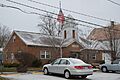
Village Hall
-
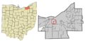
Location in Cuyahoga County and the state of Ohio.
See also
 In Spanish: Linndale (Ohio) para niños
