
List of Indiana state historical markers in Hancock County facts for kids

Have you ever seen a special sign that tells you about an important place or event? These are called historical markers! They are like outdoor history books, helping us learn about the past right where it happened. In Hancock County, Indiana, there are three official state historical markers. These markers were put up by the Indiana Historical Bureau to celebrate unique moments and people from the county's history. Let's explore what makes each of these spots special!
Contents
Hancock County's Historical Markers
Hancock County is home to some interesting stories, marked by these special signs. Each marker tells a piece of Indiana's history, from politics to famous poets and artists.
The Democratic Party Rooster's Origin
One of the markers in Hancock County celebrates a unique symbol: the rooster of the Democratic Party. This political party is one of the two main groups in American politics. The rooster became a symbol for the party during the 1800s.
Where the Rooster Symbol Began
This marker is found on East Main Street (U.S. Route 40) at Riley Park in Greenfield. It was placed in 1966. The story goes that the rooster became a symbol for the Democratic Party because of a newspaper editor named Horace Greeley. He used the image of a crowing rooster to represent the party's "cock-a-doodle-doo" spirit, meaning they were ready to fight for their beliefs. This marker reminds us of how symbols in politics can become very famous and last a long time!
James Whitcomb Riley: The Hoosier Poet
Another important marker in Hancock County honors a very famous poet, James Whitcomb Riley. He was born in Greenfield and became known as "The Hoosier Poet." A "Hoosier" is a nickname for someone from Indiana.
Life and Legacy of James Whitcomb Riley
This marker is located at 250 West Main Street (U.S. Route 40) in Greenfield. It was placed in 1967. James Whitcomb Riley was born on October 7, 1849, and passed away on July 22, 1916. He wrote many popular poems, often using everyday language and stories about Indiana life. His most famous poems include "Little Orphant Annie" and "The Raggedy Man." His birthplace is now a museum, where you can learn more about his life and works. This marker celebrates his huge contribution to American literature and culture.
John William "Will" Vawter: Artist and Illustrator
The newest historical marker in Hancock County celebrates John William "Will" Vawter, a talented artist. He was known for his beautiful illustrations, especially for books.
Vawter's Artistic Contributions
This marker was placed in 2020 and can be found on West Main Street (U.S. 40) west of State Street (Indiana Route 9) in Greenfield. Will Vawter was a skilled painter and illustrator. He is especially famous for illustrating the works of his friend, James Whitcomb Riley, the Hoosier Poet. Vawter's drawings helped bring Riley's poems to life for many readers. This marker honors his artistic talent and his role in capturing the spirit of Indiana through art.
Images for kids
-

A medallion showing the Democratic Party rooster symbol.
-
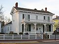
The birthplace of James Whitcomb Riley, now a museum.
-
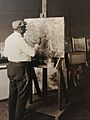
An example of a painting by Will Vawter.


See also
- List of Indiana state historical markers
- National Register of Historic Places listings in Hancock County, Indiana
