
List of Indiana state historical markers in Vanderburgh County facts for kids

Have you ever seen a special sign that tells you about something important that happened in a town? These are called historical markers, and they're like outdoor history books! They help us remember cool events, famous people, or special places from the past.
This article is all about the official historical markers you can find in Vanderburgh County, Indiana, in the United States. These markers were put up by the Indiana Historical Bureau to share interesting stories about the area. There are 11 of these markers in Vanderburgh County, each with its own unique tale. Let's explore them!
Discovering Vanderburgh County's History
These markers are like clues to the past, showing us how much Vanderburgh County has changed and grown. Each one tells a different part of the story, from old canals to famous factories and important people.
The Wabash and Erie Canal Marker
The first marker was placed way back in 1947. It tells us about the Wabash and Erie Canal, which was a huge deal for transportation a long time ago. Canals were like man-made rivers that boats used to move goods and people across the state. This marker is found in Evansville, Indiana, near the Old Vanderburgh County Courthouse. It reminds us of a time when canals were super important for business and getting around.
Indiana's First Soil and Water Conservation District
In 1976, a marker was put up to celebrate the Vanderburgh County Soil and Water Conservation District. This was the very first district of its kind in Indiana! These districts help farmers and landowners take care of the land, making sure the soil stays healthy and water is used wisely. It's located in Darmstadt, Indiana, at the Vanderburgh County 4-H Center, showing how important it is to protect our natural world.
The P-47 Thunderbolt Factory
Imagine a factory that built powerful airplanes during a war! The P-47 Thunderbolt Factory marker, placed in 1995, tells the story of a huge factory in Evansville that made P-47 Thunderbolt airplanes for World War II. These planes were super important for the military. This marker is on U.S. Route 41, reminding us of Evansville's big role in helping the country during wartime.
The Evansville Cotton Mill
In 1996, a marker appeared for the Evansville Cotton Mill. This mill was a big factory that made cotton products. It was an important part of the local economy and provided many jobs. This marker, located near the Bristol Myers Squibb facility in Evansville, highlights the history of business and industry in the area, and even the role of women in the workforce.
The McCurdy-Sears Building
The McCurdy-Sears Building got its own marker in 1999. This building is a cool piece of architecture and has been a part of Evansville's business scene for a long time. It's located in Evansville, showing off the city's interesting buildings and its history of commerce.
The Ohio River Levee
Have you ever wondered how cities near big rivers protect themselves from floods? The Ohio River Levee marker, placed in 2003, explains just that! It's located along the Ohio River in downtown Evansville. This marker teaches us about how communities work together to manage natural events like floods and protect their homes and businesses.
Sheriff's Residence and Jail
In 2007, a marker was placed at the Sheriff's Residence and Jail in Evansville. This marker helps us learn about the history of law enforcement and government in Vanderburgh County. It shows how important these institutions have been in keeping the community safe over the years.
Glenn A. Black (1900-1964)
A marker from 2017 honors Glenn Albert Black, a very important person who studied ancient Native American cultures. He was an archaeologist who helped us understand how people lived in Indiana thousands of years ago. This marker, located in Evansville, celebrates his contributions to science and our knowledge of early settlements.
Lincoln Gardens
The Lincoln Gardens marker, placed in 2020, tells the story of an important African American community in Evansville. It's located at the Evansville African American Museum. This marker helps us remember the history of neighborhoods and the contributions of African Americans to the city's development.
Mary Harris "Mother" Jones
In 2022, a marker was dedicated to Mary Harris "Mother" Jones. She was a famous labor organizer who fought for the rights of workers, especially women and children, a long time ago. She traveled all over the country to help people get fair treatment. This marker in Evansville reminds us of her important work for business, industry, and women's rights.
P-47 Thunderbolt Factory (Second Marker)
Another marker about the P-47 Thunderbolt Factory was placed in 2023, this time at the Evansville Wartime Museum. This second marker gives even more details about how Evansville helped build these powerful planes during World War II. It's a great way to learn more about the city's role in military history and its industrial past.
Images for kids
-
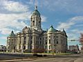
The Old Vanderburgh County Courthouse
-

A P-47D "razorback" Thunderbolt plane
-
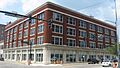
The historic McCurdy Building
-
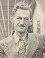
Glenn A. Black in the late 1930s
-
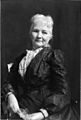
Mary Harris "Mother" Jones in 1902
-
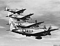
P-47 Thunderbolts from the 345th Fighter Squadron


See also
- List of Indiana state historical markers
- National Register of Historic Places listings in Vanderburgh County, Indiana
