
List of National Natural Landmarks in Washington facts for kids
There are 18 amazing National Natural Landmarks in Washington State. These are very special places, chosen because they show important parts of Earth's natural history. Think of them as nature's masterpieces! Across the whole United States, there are nearly 600 of these landmarks.
Contents
- Discover Washington's Natural Wonders
- Boulder Park and McNeil Canyon Haystack Rocks
- Davis Canyon
- Drumheller Channels
- Ginkgo Petrified Forest
- Grand Coulee
- Grande Ronde Feeder Dikes
- Grande Ronde Goosenecks
- The Great Gravel Bar of Moses Coulee
- Kahlotus Ridgetop
- Mima Mounds
- Nisqually Delta
- Point of Arches
- Rose Creek Preserve
- Sims Corner Eskers and Kames
- Steptoe and Kamiak Buttes
- Umtanum Ridge Water Gap
- Wallula Gap
- Withrow Moraine and Jameson Lake Drumlin Field
- Images for kids
Discover Washington's Natural Wonders
Washington State is home to many incredible natural sites. Each one tells a unique story about how our planet was formed. Let's explore some of these cool places!
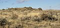
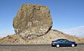
Boulder Park and McNeil Canyon Haystack Rocks

These areas show some of the best examples of glacial erratics in the United States. Glacial erratics are giant rocks that were picked up and moved by glaciers long, long ago. When the glaciers melted, they left these huge rocks behind in new places.
Davis Canyon
This canyon is one of the largest and most untouched examples of a special type of grassland. It's called the antelope bitterbrush-Idaho fescue shrub steppe. It's a great place to see what the Columbia Plateau looked like naturally.
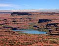
Drumheller Channels

The Drumheller Channels show how much the land changed because of huge floods. These floods happened during the late Pleistocene Ice Age. They were so powerful they carved out the volcanic land of the Columbia Plateau. Part of this landmark is inside the Columbia National Wildlife Refuge.
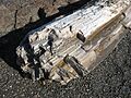
Ginkgo Petrified Forest

Imagine trees turning to stone! At Ginkgo Petrified Forest, you can see thousands of tree logs that have turned into stone over millions of years. This happened when ancient lava flows covered them. It's part of Ginkgo/Wanapum State Park.
Grand Coulee

The Grand Coulee is a huge canyon that shows a long series of amazing geological events. It's like a giant textbook of Earth's history, carved into the land.
Grande Ronde Feeder Dikes
This area has the best examples of basalt dikes. Think of these as cracks in the ground that were once filled with hot, liquid rock (lava). This lava then cooled and hardened. These dikes were the "feeders" for the huge lava flows that created the Columbia River basalt plateau.
Grande Ronde Goosenecks
The Grande Ronde Goosenecks features a canyon that is about 1,500 feet (457 meters) deep. It follows a very winding path, like a snake, along the river's turns. It's a dramatic example of how rivers can carve deep into the land.
The Great Gravel Bar of Moses Coulee
This landmark has the largest and best example of a "pendent river bar." This unique sandbar was formed by the same giant floods that swept across the Columbia Plateau. These floods were so powerful they moved huge amounts of gravel and rock.
Kahlotus Ridgetop
Kahlotus Ridgetop is a great example of the Central Palouse Prairie grassland. It shows what this type of natural grassland looked like before it was changed by human activity.
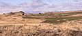
Mima Mounds

The Mima Mounds are a prairie with unusual small hills or "pimples" made of black silt and gravel. Scientists are still studying exactly how these mysterious mounds were formed!
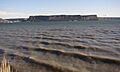
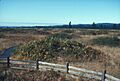
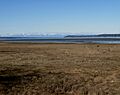
Nisqually Delta
.jpg)
The Nisqually Delta is a fantastic example of an estuarine ecosystem. This is a special place where the fresh water from a river mixes with the salty water of the ocean. It's a very important habitat for many plants and animals. The Nisqually National Wildlife Refuge is part of this area.
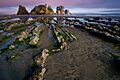
Point of Arches
.jpg)
Point of Arches shows how powerful the ocean can be. The waves have carved and shaped the rocky shoreline into amazing arches and other formations. It's a beautiful part of Olympic National Park.
Rose Creek Preserve
This preserve is the best remaining example of a specific type of forest. It's called the aspen phase of the hawthorne-cow parsnip habitat type. It's managed by The Nature Conservancy, an organization that protects natural lands.
Sims Corner Eskers and Kames

This area has the best examples of landforms left behind by melting glaciers. You can see eskers (long, winding ridges) and kames (small, cone-shaped hills). They show how the ice sheet melted and retreated during the last Ice Age.
Steptoe and Kamiak Buttes

These are isolated mountain peaks made of older rock. They stand tall above the surrounding land, which is made of younger lava flows. They are like islands of ancient rock in a sea of basalt.
Umtanum Ridge Water Gap

This geological formation shows two cool processes. First, it shows tectonic folding, where the Earth's crust has bent and folded. Second, it shows antecedent stream cutting, where a river kept cutting through the land even as the land was rising.
Wallula Gap

The Wallula Gap is the largest and most impressive of several "water gaps" in the Columbia River basin. A water gap is where a river cuts through a ridge or mountain range. This one goes through basalt anticlines, which are upward folds in the rock layers.
Withrow Moraine and Jameson Lake Drumlin Field

This area has the best examples of drumlins (oval-shaped hills formed by glaciers). It also has the clearest part of the only Pleistocene terminal moraine in the Columbia Plateau. A moraine is a pile of rocks and dirt left by a glacier's edge.
Images for kids
-
Huge rocks moved by glaciers
-
Drumheller Channels
-
Ginkgo Petrified Forest
-
Steamboat Rock
-
Mima Mounds
-
Nisqually Delta
-
Point of Arches
-
Yeager Rock
-
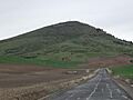
Steptoe Butte
-
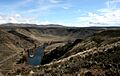
View from Umtanum Ridge
-
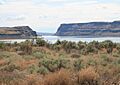
Wallula Gap
-
Withrow Moraine
