
List of Pennsylvania state historical markers in Columbia County facts for kids

Welcome to Columbia County, Pennsylvania! Did you know that this area has special markers that tell us about important events and places from the past? These are called Pennsylvania state historical markers.
These markers are like outdoor history books. They are placed by the Pennsylvania Historical and Museum Commission (PHMC) to help everyone learn about the rich history of the state. In Columbia County, there are eight of these cool markers. Let's explore some of them!
Historical Markers in Columbia County
Catawissa Friends Meeting

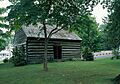
The Catawissa Friends Meetinghouse is a very old building that was important for early settlers in the area. It was a place where people called Quakers (also known as the Religious Society of Friends) gathered for worship. Quakers believe in peace and living simply.
There are actually two markers for this special place. One was put up on May 8, 1948, near U.S. Route 11 and Pennsylvania Route 42, a little southwest of Bloomsburg. The other was dedicated on May 1, 1948, right on South Street in Catawissa. These markers remind us of the important role religion and early communities played in shaping Columbia County.
Columbia County History
A marker dedicated on July 11, 1983, at the County Courthouse on Main Street in Bloomsburg, tells us about Columbia County itself. This marker highlights the county's history, including its government, important towns, and even some of its bridges. It's a great way to learn about how the county was formed and grew over time.
The Fishing Creek Confederacy
This marker, placed on July 26, 2009, in Benton, tells a unique story from the time of the American Civil War. During the Civil War (1861-1865), some people in this area had different ideas about the war. The "Fishing Creek Confederacy" refers to a group of people who were against the war and tried to avoid being drafted into the army.
This marker helps us remember a complex time in American history, showing how different communities reacted to the challenges of the Civil War. It also connects to larger historical figures like Abraham Lincoln, who was president during this period.
Fort Jenkins
On May 8, 1948, a marker was placed northeast of Bloomsburg to remember Fort Jenkins. This fort was important during the American Revolution (1775-1783). It was built to protect early settlers from attacks, especially from some Native American groups who were allied with the British during the war. Fort Jenkins reminds us of the dangers and challenges faced by people settling in Pennsylvania long ago.
Fort McClure
Another important fort from the American Revolution, Fort McClure, is remembered by a marker placed on May 8, 1948, near U.S. Route 11 at the Fairgrounds in Bloomsburg. Like Fort Jenkins, Fort McClure was a defensive outpost. It played a role in protecting the early communities and their families during a time of conflict and uncertainty. These forts were crucial for the safety and survival of the pioneers.
Fort Wheeler
The marker for Fort Wheeler was dedicated on May 10, 1948, on Pennsylvania Route 487, northeast of Bloomsburg. This fort also served as a protective site during the American Revolution. It was part of a network of small forts and blockhouses built to defend the frontier settlements against attacks. Learning about these forts helps us understand the military strategies and daily lives of people living in Pennsylvania during the Revolutionary War.
Wyoming Path
On May 3, 1949, a marker was placed on West 2nd Street (U.S. Route 11) near the Fairgrounds in Bloomsburg, marking the Wyoming Path. This path was an ancient trail used by Native Americans for centuries. It was an important route for travel, trade, and communication between different Native American communities. Later, European settlers also used parts of these trails. The Wyoming Path marker reminds us of the long history of human movement and connection in this region, even before the arrival of European settlers.
See also
- List of Pennsylvania state historical markers
- National Register of Historic Places listings in Columbia County, Pennsylvania
Images for kids
-
The historic Catawissa Friends Meetinghouse.
-

A placeholder image for a marker without a specific photo.

