
List of Pennsylvania state historical markers in Snyder County facts for kids

Have you ever seen a special sign by the road or in a town that tells you about something important that happened there a long time ago? These are called historical markers. They are like outdoor history books! In Snyder County, Pennsylvania, there are 15 of these markers. They were put there by the Pennsylvania Historical and Museum Commission (PHMC), which is a group that helps protect and share Pennsylvania's history.
These markers tell us about exciting events, important people, and interesting places in Snyder County's past. They help us learn about everything from old battles and famous leaders to how people traveled long ago. Let's explore some of these cool historical spots!
Historical Markers in Snyder County
Albany Purchase
The Albany Purchase marker tells us about a big land deal that happened in 1754. This was when the British bought a huge area of land from the Iroquois Native Americans in Albany, New York. This purchase included parts of what is now Snyder County. It was a very important event for how Pennsylvania grew and changed. You can find this marker about one mile north of Selinsgrove on US 522, where US 11 and 15 also meet.
Coxey's Army
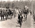
The Coxey's Army marker remembers a unique event from 1894. During a tough economic time, a man named Jacob Coxey led a group of unemployed people on a march from Ohio to Washington, D.C. They were asking the government for help. This group, known as "Coxey's Army," passed through Selinsgrove. It was a big moment in American history, showing how people tried to make their voices heard. The marker is at 814 N. Market Street in Selinsgrove.
Fort Augusta
The Fort Augusta marker reminds us of a strong fort built during the French and Indian War (1754-1763). This war was fought between the British and French, with their Native American allies, over land in North America. Fort Augusta was a very important British outpost on the frontier, helping to protect settlers. The marker is near the Northumberland Bridge, about 5.9 miles northwest of Selinsgrove on U.S. 11.
Harris Ambush
The Harris Ambush - PLAQUE marker tells a story from the French and Indian War. In 1755, a group of Native Americans attacked a supply convoy led by John Harris, a famous trader and founder of Harrisburg. This ambush happened near the Old Bridge, about half a mile west of Selinsgrove. It shows how dangerous life was on the Pennsylvania frontier during that time.
Lock Number Seven
The Lock Number Seven marker points to a part of the old Pennsylvania Canal system. Canals were like man-made rivers that helped boats carry goods and people across the state before railroads were common. Locks were special sections that allowed boats to move between different water levels. This marker is on U.S. 15 and 11 at Mahantango Creek.
Penn's Creek Massacre
The Penn's Creek Massacre marker remembers a tragic event from 1755, during the French and Indian War. A group of Native Americans attacked a settlement along Penns Creek, killing and capturing many settlers. This event was one of the first major attacks on Pennsylvania's frontier during the war. It showed the dangers faced by early settlers. The marker is on SR 2017, just north of Selinsgrove. There's also another plaque for the Penns Creek Massacre near the south end of Old Trail, just east of US 11 and 15.
Pennsylvania Canal (Susquehanna Division)
The Pennsylvania Canal (Susquehanna Division) marker highlights another part of the important canal system. The Susquehanna Division of the canal ran along the Susquehanna River, helping to transport coal, lumber, and farm products. Canals were vital for trade and travel in the 1800s. This marker is on U.S. 11 and 15 at Port Trevorton.
Schoch Blockhouse
The Schoch Blockhouse marker tells us about a small fort or "blockhouse" that was used during the American Revolution (1775-1783). Blockhouses were simple, strong buildings that settlers could use for protection against attacks. This one was located near the village of Kreamer on US 522, near the railroad crossing.
Shikellamy
The Shikellamy marker honors a very important Native American leader. Shikellamy was a chief of the Oneida people and a representative of the Iroquois Confederacy in the early 1700s. He played a key role in relations between Native American tribes and the Pennsylvania government. He worked hard to keep peace. The marker is on U.S. 11, about 5.4 miles north of Selinsgrove, at the entrance to Shikellamy State Park.
Simon Snyder
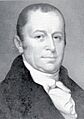
The Simon Snyder marker celebrates a famous person from Snyder County: Simon Snyder. He was the third Governor of Pennsylvania, serving from 1808 to 1817. He was the first governor from west of the Susquehanna River and was known for his support of ordinary people. His marker is at 121 N. Market Street in Selinsgrove.
Simon Snyder Mansion
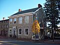
The Simon Snyder Mansion - PLAQUE marks the home of Governor Simon Snyder. This house was where he lived and worked, and it's an important piece of history connected to his time as governor. The plaque is also at 121 N. Market Street in Selinsgrove.
Snyder County
The Snyder County marker celebrates the county itself! Snyder County was formed in 1855 from parts of Union County. It was named after Governor Simon Snyder. This marker is at the County Courthouse, 9 W. Market Street (US 522) in Middleburg.
Sunbury
The Sunbury marker tells us about the nearby town of Sunbury, which was an important place in early Pennsylvania history. It was founded in 1772 and was a key trading post and military center, especially during the French and Indian War. The marker is on U.S. 11 and 15, about 4 miles north of Selinsgrove.
Susquehanna University
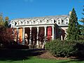
The Susquehanna University marker highlights a well-known university in Selinsgrove. Susquehanna University was founded in 1858 as the Missionary Institute of the Evangelical Lutheran Church. It has grown into a respected university known for its education programs. The marker is on University Avenue near 18th Street in Selinsgrove.
Images for kids
-

Albany Purchase marker (placeholder)
-
Coxey's Army marching in 1894
-
Fort Augusta marker (placeholder)
-
Harris Ambush marker (placeholder)
-
Lock Number Seven marker (placeholder)
-
Penn's Creek Massacre marker (placeholder)
-
Penns Creek Massacre - PLAQUE (placeholder)
-
Pennsylvania Canal (Susquehanna Division) marker (placeholder)
-
Schoch Blockhouse marker (placeholder)
-
Shikellamy marker (placeholder)
-
Portrait of Governor Simon Snyder
-
The Simon Snyder Mansion
-
Snyder County marker (placeholder)
-
Sunbury marker (placeholder)
-
Seibert Hall at Susquehanna University


See also
- List of Pennsylvania state historical markers
- National Register of Historic Places listings in Snyder County, Pennsylvania
