
List of Roman-to-modern scheduled monuments in Powys (Montgomeryshire) facts for kids
Powys is the largest county in Wales. It covers a huge part of eastern Wales, with lots of remote hills and not many people. It also has no coastline. Powys was formed in 1974 and includes three older areas: Montgomeryshire, Radnorshire, and most of Brecknockshire.
There are 950 special historical sites, called scheduled monuments, in Powys. That's a lot! So, these sites are split into lists for each of the three historic areas. Each area then has two lists: one for very old, prehistoric sites and another for sites from Roman times, the Middle Ages, and more recent periods.
This article focuses on the Roman, medieval, and post-medieval sites in Montgomeryshire. This area is in the northern part of Powys. Out of 303 scheduled monuments in Montgomeryshire, 190 are from prehistoric times. This list covers the other 113 sites. These include 16 Roman sites, mostly related to the Roman army. There are 25 Early Medieval sites, like parts of Offa's Dyke, other earthworks, and an old carved stone. The 62 medieval sites are mainly defensive structures like castles and mounds called mottes. The ten post-medieval sites include old mines, bridges, and even a railway.
Scheduled Ancient Monuments (SAMs) are protected by law. This means it's against the law to dig up or damage them. The Welsh government agency, Cadw, creates and looks after this list.
Contents
What are Scheduled Monuments?
Scheduled Monuments are important historical sites that are legally protected. This protection helps make sure these places are preserved for future generations. It's like a special shield for old buildings, ruins, or even just marks in the ground that tell us about the past.
Roman Sites in Montgomeryshire
The Roman period in Britain lasted for about 400 years, from 43 AD to 410 AD. The Roman army built many forts and roads in Wales to control the land. In Montgomeryshire, you can find 16 Roman sites. Most of these were military bases or parts of their road network.
- Caersws Roman Fort: This was an important Roman fort and settlement. You can still see parts of its old defenses and nearby areas where people lived (called a vicus).
- Roman Roads: The Romans were famous for their straight roads. You can find sections of these ancient roads, like the Caersws Roman Road, which helped the army move quickly.
- Forden Gaer: Another Roman fort site, showing where the Romans set up camp.
- Craig-y-Mwyn Lead Mine: This site shows that the Romans were also interested in natural resources, like lead.
Early Medieval Sites: Dykes and Stones
The Early Medieval period in Wales is roughly from 410 AD to 1066 AD. During this time, people built large earthworks, often as boundaries or defenses.
- Offa's Dyke: A very famous example is Offa's Dyke. This huge earth wall was built in the 8th century by King Offa of Mercia. It marked the border between his kingdom and the Welsh kingdoms. Many sections of this dyke, like the one near Churchstoke, are still visible today.
- Other Dykes: Besides Offa's Dyke, there are other linear earthworks like Aber Bechan Dyke and Clawdd Llesg. These were also likely used for defense or to mark land boundaries.
- Cross-Incised Stone: An old stone with a cross carved into it, now found in Carno Church. These stones often marked important places or graves.
- Hen Domen Pre-Conquest Fields: These are traces of old field systems from before the Norman Conquest in 1066. They show how people farmed the land long ago.
Medieval Castles and Settlements
The Medieval period in Wales spans from 1066 AD to around 1500 AD. This was a time of many conflicts, and a lot of defensive structures were built.
- Motte and Bailey Castles: These were the earliest types of castles built by the Normans. A motte is a large mound of earth, often topped with a wooden tower. A bailey is a walled courtyard next to it. Many sites in Montgomeryshire, like Sycharth Mound and Bailey Castle, are examples of these.
- Sycharth Castle: This was the birthplace and home of Owain Glyndŵr, a famous Welsh leader. It was destroyed by the future King Henry V of England. Today, you can see the grassy earthworks of this important historical site.
- Stone Castles: Later, stronger castles made of stone were built, like Montgomery Castle and Dolforwyn Castle. These were important strongholds.
- Moated Sites: These were homes or farmsteads surrounded by a ditch filled with water for defense. Examples include Plas Yr Alarch Moated Site.
- Medieval Towns: Parts of old medieval towns, like Montgomery, are also protected. These show how towns were laid out and defended with walls and ditches.
- Gallows: A site called Pen y Crogben Round Barrow is listed as a gallows, showing where criminals might have been executed in medieval times.
Post-Medieval and Modern Sites
The Post-Medieval and Modern period starts around 1500 AD and continues to more recent times. These sites show how life and industry changed.
- Lead Mines: Mining was an important industry in Wales. Sites like Bryntail Lead Mine Buildings and Nant yr Eira Prehistoric Copper Mines & 19th Century Lead Mine show the remains of old mining operations.
- Bridges: Important bridges, like Llandrinio Bridge and Machynlleth Bridge, are protected as historical structures.
- Railway Transfer Dock: This site in Welshpool shows how railways played a role in moving goods and people in more recent history.
- Root Store: A root store at Bon-y-Maen is an example of an agricultural building from this period.
Images for kids
-
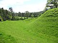
Motte and Bailey of Sycharth Castle, home of Owain Glyndŵr.

See also
